Randleman, North Carolina

Last updated

Randleman, North Carolina
Randleman, North Carolina.jpg
Main Street
NCMap-doton-Randleman.PNG
Location of Randleman, North Carolina
Coordinates: 35°48′59″N79°48′24″W / 35.81639°N 79.80667°W / 35.81639; -79.80667
Country United States
State North Carolina
County Randolph
Incorporated1880
Named for John B. Randleman [1]
Area
[2]
  Total4.12 sq mi (10.67 km2)
  Land4.08 sq mi (10.57 km2)
  Water0.04 sq mi (0.11 km2)
Elevation
[3]
715 ft (218 m)
Population
 (2020)
  Total4,595
  Density1,126.23/sq mi (434.81/km2)
Time zone UTC-5 (Eastern (EST))
  Summer (DST) UTC-4 (EDT)
ZIP code
27317
Area code 336
FIPS code 37-55080 [4]
GNIS feature ID2404592 [3]
Website cityofrandleman.com

Randleman is a city in Randolph County, North Carolina, United States. The population was 4,113 at the 2010 census. It is the home of NASCAR's Petty family, the Victory Junction Gang Camp and was the location of the Richard Petty Museum from 2003 to 2014.

Contents

Geography

According to the United States Census Bureau, the city has a total area of 3.6 square miles (9.3 km2), of which 3.6 square miles (9.3 km2) is land and 0.04 square miles (0.10 km2) (0.83%) is water.

History

The town was originally named Dicks for Rick Dicks, who built a mill there circa 1830. Later, a cotton mill was built in Dicks, and the town was renamed Union Factory. [5]

Deep River Mills in Randleman, 1917 Deep River Mills, Randleman.png
Deep River Mills in Randleman, 1917

Randleman was the next name chosen, in 1866. The town's namesake was John B. Randleman, a mill owner. The town was incorporated as Randleman Mills in 1880; the name was later changed to Randleman. [1]

William Dennis Pottery Kiln and House Site and Randleman Graded School are listed on the National Register of Historic Places. [6] [7]

Demographics

Historical population
CensusPop.Note
1880 1,027
1890 1,75470.8%
1900 2,19024.9%
1910 1,950−11.0%
1920 1,9670.9%
1930 1,863−5.3%
1940 2,0329.1%
1950 2,0661.7%
1960 2,2328.0%
1970 2,3123.6%
1980 2,156−6.7%
1990 2,61221.2%
2000 3,55736.2%
2010 4,11315.6%
2020 4,59511.7%
U.S. Decennial Census [8]

2020 census

Randleman racial composition [9]
RaceNumberPercentage
White (non-Hispanic)3,50276.21%
Black or African American (non-Hispanic)3347.27%
Native American 200.44%
Asian 320.7%
Pacific Islander 10.02%
Other/Mixed 2104.57%
Hispanic or Latino 49610.79%

As of the 2020 United States census, there were 4,595 people, 1,662 households, and 1,030 families residing in the city.

2000 census

As of the census [4] of 2000, there were 3,557 people, 1,452 households, and 985 families residing in the city. The population density was 997.4 inhabitants per square mile (385.1/km2). There were 1,542 housing units at an average density of 432.4 per square mile (167.0/km2). The racial makeup of the city was 91.23% White, 3.71% African American, 0.34% Native American, 0.39% Asian, 2.81% from other races, and 1.52% from two or more races. Hispanic or Latino of any race were 8.38%.

There were 1,452 households, out of which 35.5% had children under the age of 18 living with them, 47.7% were married couples living together, 15.2% had a female householder with no husband present, and 32.1% were non-families. 29.5% of all households were made up of individuals, and 12.2% had someone living alone who was 65 years of age or older. The average household size was 2.42 and the average family size was 2.96.

In the city, the population was spread out, with 26.7% under the age of 18, 8.1% from 18 to 24, 31.4% from 25 to 44, 20.5% from 45 to 64, and 13.4% who were 65 years of age or older. The median age was 34 years. For every 100 females, there were 88.7 males. For every 100 females age 18 and over, there were 85.0 males.

The median income for a household in the city was $30,572, and the median income for a family was $35,123. Males had a median income of $27,692 versus $21,806 for females. The per capita income for the city was $14,286. About 8.5% of families and 11.2% of the population were below the poverty line, including 17.2% of those under age 18 and 15.2% of those age 65 or over.

Notable structures

The American Towers Tower Randleman is a guyed mast for TV transmissions with a height of 1,853.88 feet.

Notable people

Education

Randolph County School System operates public schools. Randleman Elementary is the only school within the city limits of Randleman with Randleman High and Randleman Middle just outside the city. Level Cross Elementary is also near and has a Randleman address.

Attractions

Related Research Articles

<span class="mw-page-title-main">Kannapolis, North Carolina</span> City in North Carolina, United States

Kannapolis is a city in Cabarrus and Rowan counties, in the U.S. state of North Carolina, northwest of Concord and northeast of Charlotte and is a suburb in the Charlotte metropolitan area. The city of Kannapolis was incorporated in 1984. The population was 53,114 at the 2020 census, which makes Kannapolis the 19th-most populous city in North Carolina. It is the home of the Kannapolis Cannon Ballers, the Low-A baseball affiliate of the Chicago White Sox, and it is the hometown of the Earnhardt racing family. It is also the headquarters for the Haas F1 racing team. The center of the city is home to the North Carolina Research Campus, a public-private venture that focuses on food, nutrition, and biotech research.

<span class="mw-page-title-main">Randolph County, North Carolina</span> County in North Carolina, United States

Randolph County is a county located in the U.S. state of North Carolina. As of the 2020 census, the population was 144,171. Its county seat is Asheboro.

<span class="mw-page-title-main">Dawsonville, Georgia</span> City in Georgia, United States

Dawsonville is a city in and the county seat of Dawson County, Georgia, United States. The population was 2,536 at the 2010 census, up from 619 in 2000.

<span class="mw-page-title-main">Green Level, North Carolina</span> Town in North Carolina, United States

Green Level is a town in Alamance County, North Carolina, United States. It is part of the Burlington, North Carolina Metropolitan Statistical Area. As of the 2020 census, the population was 3,156.

<span class="mw-page-title-main">Catawba, North Carolina</span> Town in North Carolina, United States

Catawba is a town in Catawba County, North Carolina, United States. The population was 603 at the 2010 census. It is part of the Hickory–Lenoir–Morganton Metropolitan Statistical Area. As with the county, the name recalls the Catawba people, the indigenous people who once inhabited the area.

<span class="mw-page-title-main">Claremont, North Carolina</span> City in North Carolina, United States

Claremont is a city in Catawba County, North Carolina, United States. The population was 1,352 at the 2010 census. It is part of the Hickory–Lenoir–Morganton Metropolitan Statistical Area.

<span class="mw-page-title-main">Newton, North Carolina</span> City in North Carolina, United States

Newton is a city in Catawba County, North Carolina, United States. As of the 2010 census, the city had a population of 12,968. It is the county seat of Catawba County. Newton is part of the Hickory–Lenoir–Morganton Metropolitan Statistical Area.

<span class="mw-page-title-main">Sherrills Ford, North Carolina</span> Unincorporated community in North Carolina, United States

Sherrills Ford is an unincorporated community and former census-designated place (CDP) in Catawba County, North Carolina, United States. Since the 2010 census, it has been included within the Lake Norman of Catawba CDP. It is part of the Hickory-Lenoir-Morganton Metropolitan Statistical Area.

<span class="mw-page-title-main">Welcome, North Carolina</span> Census-designated place in North Carolina, United States

Welcome is a census-designated place (CDP) in Davidson County, North Carolina, United States. The population was 4,162 at the 2010 census. It is nationally known as the home of Richard Childress Racing. In addition, Walker and Associates, Inc., a nationwide communication value-add distribution is headquartered here. The town motto is "Welcome to Welcome, A Friendly Place," as posted on the welcoming sign. Neighboring communities and municipalities include Midway, Arcadia, and Lexington.

<span class="mw-page-title-main">Lewisville, North Carolina</span> Town in North Carolina, United States

Lewisville is a town in Forsyth County, North Carolina, United States. The population was 13,388 at the 2020 census, up from 12,639 in 2010. It is a Piedmont Triad community.

<span class="mw-page-title-main">Oak Ridge, North Carolina</span> Town in North Carolina, United States

Oak Ridge is a town in northwestern Guilford County, North Carolina, United States. As of the census of 2020, the town had a population of 7,474. Oak Ridge is 15 miles (24 km) northwest of the center of Greensboro, North Carolina's third-most populous city. Oak Ridge is a part of the Piedmont Triad urban area.

<span class="mw-page-title-main">Pleasant Garden, North Carolina</span> Town in North Carolina, United States

Pleasant Garden is a town in Guilford County, North Carolina, United States.

<span class="mw-page-title-main">Mooresville, North Carolina</span> Town in North Carolina, United States

Mooresville is a town located in the southwestern section of Iredell County, North Carolina, United States, and is a part of the fast-growing Charlotte metropolitan area. The population was 50,193 at the 2020 census, making it the most populous municipality in Iredell County. It is located approximately 25 miles (40 km) north of Charlotte.

<span class="mw-page-title-main">Richlands, North Carolina</span> Town in North Carolina, United States

Richlands is a town in Onslow County, North Carolina, United States. In the 2020 U.S. census, the population was 2,287. It is included in the Jacksonville, North Carolina Metropolitan Statistical Area. Incorporated on March 29, 1880, it was the first town in Onslow County to have its own library and museum. Richlands was also the first town in Onslow County to have a female mayor, Annette Hargett.

<span class="mw-page-title-main">Asheboro, North Carolina</span> City in North Carolina, United States

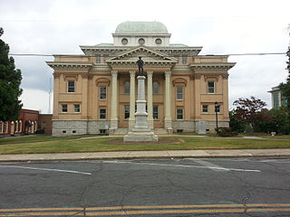
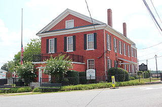
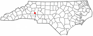
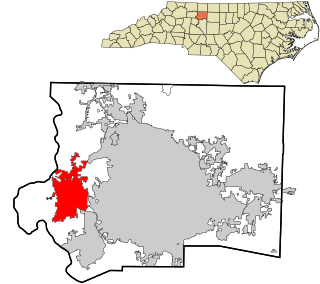
Asheboro is a city in and the county seat of Randolph County, North Carolina, United States. The population was 27,156 at the 2020 census. It is part of the Greensboro–High Point Metropolitan Area of the Piedmont Triad and is home of the state-owned North Carolina Zoo.

<span class="mw-page-title-main">Trinity, North Carolina</span> City in North Carolina, United States

Trinity is a city in Randolph County, North Carolina, United States. The population was 7,006 at the 2020 census. Trinity is part of the Greensboro-High Point Metropolitan Statistical Area of the Piedmont Triad metro region.

<span class="mw-page-title-main">Walnut Cove, North Carolina</span> Town in North Carolina, United States

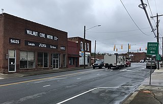
Walnut Cove is a town in Stokes County, North Carolina, United States. The population was 1,536 at the 2020 census.

<span class="mw-page-title-main">Annville Township, Pennsylvania</span> Township in Pennsylvania, United States

Annville Township is a township and census-designated place in Lebanon County, Pennsylvania, United States. The population was 4,767 at the 2010 census.

<span class="mw-page-title-main">Ridgeway, Virginia</span> Town in Virginia, United States

Ridgeway is a town in Henry County, Virginia, United States. The population was 742 at the 2010 census. It is part of the Martinsville Micropolitan Statistical Area. Martinsville Speedway, a NASCAR racetrack, is located between Ridgeway and the Martinsville city limits.

<span class="mw-page-title-main">Thomasville, North Carolina</span> City in North Carolina, United States

Thomasville is a city in Davidson County, North Carolina, United States. The population was 27,183 at the 2020 census. The city was once notable for its furniture industry, as were its neighbors High Point and Lexington. This Piedmont Triad community was established in 1852 and hosts the state's oldest festival, "Everybody's Day".

References

  1. 1 2 "North Carolina Gazetteer" . Retrieved November 24, 2023.
  2. "ArcGIS REST Services Directory". United States Census Bureau. Retrieved September 20, 2022.
  3. 1 2 U.S. Geological Survey Geographic Names Information System: Randleman, North Carolina
  4. 1 2 "U.S. Census website". United States Census Bureau . Retrieved January 31, 2008.
  5. https://cityofrandleman.com/visitors/history_of_randleman.php
  6. "National Register Information System". National Register of Historic Places . National Park Service. July 9, 2010.
  7. "National Register of Historic Places Listings". Weekly List of Actions Taken on Properties: 1/21/14 through 1/24/14. National Park Service. January 31, 2014.
  8. "Census of Population and Housing". Census.gov. Retrieved June 4, 2015.
  9. "Explore Census Data". data.census.gov. Retrieved December 20, 2021.

Source

Powell, William, The North Carolina Gazetteer, University of North Carolina Press, Chapel Hill, 1968.