
State Route 99 (SR 99), also known as the Pacific Highway, is a state highway in the Seattle metropolitan area, part of the U.S. state of Washington. It runs 49 miles (79 km) from Fife to Everett, passing through the cities of Federal Way, SeaTac, Seattle, Shoreline, and Lynnwood. The route primarily follows arterial streets, including Aurora Avenue, and has several freeway segments, including the tolled SR 99 Tunnel in Downtown Seattle. SR 99 was officially named the William P. Stewart Memorial Highway by the state legislature in 2016, after a campaign to replace an unofficial moniker honoring Confederate president Jefferson Davis.

West Seattle is a conglomeration of neighborhoods in Seattle, Washington, United States. It comprises two of the thirteen districts, Delridge and Southwest, and encompasses all of Seattle west of the Duwamish River. It was incorporated as an independent town in 1902 before being annexed by Seattle five years later. Among the area's attractions are its saltwater beach parks along Elliott Bay and Puget Sound, including Alki Beach Park and Lincoln Park. The area is also known for its views of the Olympic Mountains to the west and the Cascade Range to the east. One-third of Seattle's green space and urban forest is located in West Seattle, much of it in the West Duwamish Greenbelt.

The Downtown Seattle Transit Tunnel (DSTT), also referred to as the Metro Bus Tunnel, is a 1.3-mile-long (2.1 km) pair of public transit tunnels in Seattle, Washington, United States. The double-track tunnel and its four stations serve Link light rail trains on the 1 Line as it travels through Downtown Seattle. It runs west under Pine Street from 9th Avenue to 3rd Avenue, and south under 3rd Avenue to South Jackson Street. 1 Line trains continue north from the tunnel to Lynnwood City Center and south through the Rainier Valley past Seattle–Tacoma International Airport to Angle Lake station as part of Sound Transit's light rail network.

King County Metro, officially the King County Metro Transit Department and often shortened to Metro, is the public transit authority of King County, Washington, which includes the city of Seattle. It is the eighth-largest transit bus agency in the United States. In 2023, the system had a ridership of 78,121,600, or about 277,400 per weekday as of the third quarter of 2024. Metro employs 2,477 full-time and part-time operators and operates 1,540 buses.

Transportation in Seattle is largely focused on the automobile like many other cities in western North America; however, the city is just old enough for its layout to reflect the age when railways and trolleys predominated. These older modes of transportation were made for a relatively well-defined downtown area and strong neighborhoods at the end of several former streetcar lines, now mostly bus lines.

The 1 Line, formerly Central Link, is a light rail line in Seattle, Washington, United States, and part of Sound Transit's Link light rail system. It serves 23 stations in King and Snohomish counties, traveling 33 miles (53 km) between Lynnwood City Center and Angle Lake stations. The line connects Lynnwood, Mountlake Terrace, Shoreline, the University District, Downtown Seattle, the Rainier Valley, and Seattle–Tacoma International Airport. The 1 Line carried over 26 million total passengers in 2023, with an average of nearly 80,000 daily passengers on weekdays. It runs for 20 hours per day on weekdays and Saturdays, with headways as low as six minutes during peak hours, and reduced 18-hour service on Sundays and holidays.

The South Lake Union Streetcar, officially the South Lake Union Line, is a streetcar route in Seattle, Washington, United States, forming part of the Seattle Streetcar system. It travels 1.3 miles (2.1 km) and connects Downtown Seattle to the South Lake Union neighborhood on Westlake Avenue, Terry Avenue, and Valley Street. The South Lake Union Streetcar was the first modern line to operate in Seattle, beginning service on December 12, 2007, two years after a separate heritage streetcar ceased operations.

International District/Chinatown station is a light rail station that is part of the Downtown Seattle Transit Tunnel in Seattle, Washington, United States. The station is located at the tunnel's south end, at 5th Avenue South and South Jackson Street in the Chinatown-International District neighborhood, and is served by the 1 Line of Sound Transit's Link light rail system. The station is located adjacent to Sound Transit headquarters at Union Station, as well as intermodal connections to Amtrak and Sounder commuter rail at King Street Station and the First Hill Streetcar.

Pioneer Square station is a light rail station that is part of the Downtown Seattle Transit Tunnel in Seattle, Washington, United States. The station is located under 3rd Avenue at James Street, between Symphony and International District/Chinatown stations. It is served by the 1 Line, part of Sound Transit's Link light rail system, and provides connections to local buses and Colman Dock, a major ferry terminal serving areas west of Seattle.

Symphony station, formerly University Street station, is a light rail station that is part of the Downtown Seattle Transit Tunnel in Seattle, Washington, United States. The station is located under 3rd Avenue at University Street, near Benaroya Hall, and is served by Sound Transit's 1 Line. It is located between Westlake and Pioneer Square stations and has surface connections to buses operated by King County Metro and other providers.

Westlake station is a light rail station that is part of the Downtown Seattle Transit Tunnel in Seattle, Washington, United States. The station is located under Pine Street between 3rd and 6th avenues in Downtown Seattle, near Westlake Center and Westlake Park. It is served by the 1 Line, part of Sound Transit's Link light rail system, and also connected above ground by buses at several stops, the South Lake Union Streetcar, and the Seattle Center Monorail.

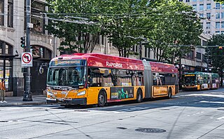
RapidRide is a network of limited-stop bus routes with some bus rapid transit features in King County, Washington, operated by King County Metro. The network consists of eight routes totaling 76 miles (122 km) that carried riders on approximately 64,860 trips on an average weekday in 2016, comprising about 17 percent of King County Metro's total daily ridership.

Northgate is a light rail and bus station in the Northgate neighborhood of Seattle, Washington, United States, and part of 1 Line on Sound Transit's Link light rail system. The transit center, located adjacent to the Northgate Mall, has four bus bays served by 22 routes. The station also has parking for 1,475 vehicles.

Bellevue Transit Center (BTC) is a bus station and light rail station in Bellevue, Washington, a suburb of Seattle. It is the main transit hub for the Eastside of King County, serving 20 routes from King County Metro and Sound Transit Express. The transit center is the western terminus of the RapidRide B Line, which runs east to Redmond.

The A Line is one of eight RapidRide lines operated by King County Metro in King County, Washington. The A Line began service on October 2, 2010, running from Tukwila to Federal Way, mostly along Pacific Highway South. The northern terminus is Tukwila/International Boulevard Station. From there, riders can transfer to Sound Transit's Link light rail, the RapidRide F Line, or to other King County Metro buses that serve Burien, Tukwila, SeaTac, Georgetown, SoDo, and downtown Seattle. Its southern terminus is Federal Way Transit Center and connects riders to buses serving Tacoma, Pierce County, and Auburn. Between the termini there are a total of 13 stations plus 13 intermediate stops.

The B Line is one of eight RapidRide lines operated by King County Metro in King County, Washington. The B Line began service on October 1, 2011, running between downtown Redmond, Overlake and downtown Bellevue. The line runs mainly via NE 8th Street, 156th Avenue NE, NE 40th Street and 148th Avenue NE. Unlike most of the RapidRide lines, the B Line does not offer scheduled service during late-night and early morning hours.

The D Line is one of eight RapidRide lines operated by King County Metro in King County, Washington. The D Line began service on September 29, 2012, running between Carkeek Park in Crown Hill, Ballard, Interbay and Uptown and downtown Seattle. The line runs via Holman Road NW, 15th Ave NW, 15th Ave W, Elliott Ave W, W Mercer Pl, Queen Anne Ave N/1st Ave N and 3rd Ave.
The RapidRide E Line is one of eight RapidRide lines operated by King County Metro in King County, Washington. The E Line began service on February 15, 2014, running from Aurora Village Transit Center in Shoreline to Pioneer Square in Downtown Seattle. The line runs primarily on Aurora Avenue North and 3rd Avenue. The line's northern terminus connects to the Swift Blue Line operated by Community Transit, which continues north on State Route 99 to Everett Station.

The RapidRide G Line is a RapidRide bus service in Seattle, Washington, operated by King County Metro on Madison Street between Downtown Seattle and Madison Valley. It uses five-door articulated buses to serve a mix of side and center platforms at its 21 stations. The line opened for service on September 14, 2024, and cost $133.4 million to construct; it features several sections with bus lanes and transit signal priority.

Westlake Avenue is a major street in Seattle, Washington, connecting Downtown Seattle to the neighborhoods of South Lake Union, Westlake and northeastern Queen Anne. The street runs north–south along the west side of Lake Union for 2.5 miles (4.0 km) from McGraw Square to the Fremont Bridge.


