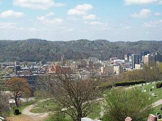
Charleston is the most populous city in, and the capital of, the U.S. state of West Virginia. Located at the confluence of the Elk and Kanawha rivers, the population during the 2017 Census Estimate was 47,929. The Charleston metropolitan area as a whole had 214,406 residents. Charleston is the center of government, commerce, and industry for Kanawha County, of which it is the county seat.

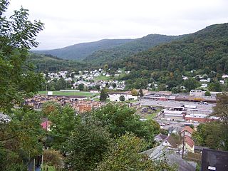
Bluefield is a town in Tazewell County, Virginia, United States, located along the Bluestone River. The population was 5,444 at the 2010 census. It is part of the Bluefield WV-VA micropolitan area which has a population of 107,342. The micropolitan area is the 350th largest statistical population area in the United States.

Shinnston is a city and former coal town in Harrison County, West Virginia, United States, along the West Fork River. In 1778 Levi Shinn constructed his log home along what is now Route 19; today it is the oldest standing structure in north-central West Virginia. As of the 2010 census, Shinnston had a population of 2,201.
Richwood is a city in Nicholas County, West Virginia, United States. In 2010, the census showed Richwood with a population of 2,051. During the 19th and early 20th century Richwood was a booming coal and lumber town. Richwood has a very rich history, including the formation of the Cherry River Navy civic organization to draw attention to issues important to the community. Richwood has also became known statewide as the "Ramp Capital of the World". Each year, in April, the city hosts a large festival that draws visitors from around the country.

The Virginia Peninsula is a peninsula in southeast Virginia, USA, bounded by the York River, James River, Hampton Roads and Chesapeake Bay. It is sometimes known as the Lower Peninsula to distinguish it from two other peninsulas to the north, the Middle Peninsula and the Northern Neck.

The Middle Peninsula is the second of three large peninsulas on the western shore of Chesapeake Bay in Virginia, in the United States. It lies between the Northern Neck and the Virginia Peninsula. This peninsula is bounded by the Rappahannock River on the north and the York River on the south, with the Chesapeake Bay to the east. It encompasses six Virginia counties: Essex, Gloucester, King and Queen, King William, Mathews, and Middlesex. Developed for tobacco plantations in the colonial era, in the 21st century the Middle Peninsula is known for its quiet rural life, vegetable truck-farming, and fishing industry.

Lost City is an unincorporated community on the Lost River in eastern Hardy County, West Virginia, United States. Lost City is centered at the intersection of West Virginia routes 59 and 259. The town was originally known as Cover. Its post office has been open since 1892.

Big Run is a 4.4-mile-long (7.1 km) tributary stream of the South Branch Potomac River, belonging to the Potomac River and Chesapeake Bay watersheds. Big Run flows through the city of Romney and the campus of the West Virginia Schools for the Deaf and Blind in Hampshire County, West Virginia. The stream is known by local residents as Town Run and Town Creek.
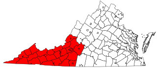
Southwest Virginia, often abbreviated as SWVA, is a mountainous region of Virginia in the westernmost part of the commonwealth. Located within the broader region of western Virginia, Southwest Virginia has been defined alternatively as all Virginia counties on the Appalachian Plateau, all Virginia counties west of the Eastern Continental Divide, or at its greatest expanse, as far east as Blacksburg and Roanoke. Another geographic categorization of the region places it as those counties within the Tennessee River watershed. Regardless of how borders are drawn, Southwest Virginia differs from the rest of the commonwealth in that its culture is more closely associated with Appalachia than the other regions of Virginia. Historically, the region has been and remains rural, but in the 20th century, coal mining became an important part of its economy. With the decline in the number of coal jobs and the decline of tobacco as a cash crop, Southwest Virginia is increasingly turning to tourism as a source of economic development. Collectively, Southwest Virginia's craft, music, agritourism and outdoor recreation are referred to as the region's "creative economy."
The following is a list of lists of the cities, towns and villages of the United States separated by state, territory or district name.
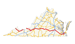
U.S. Route 460 in Virginia runs west-east through the southern part of the Commonwealth. The road has two separate pieces in Virginia, joined by a relatively short section in West Virginia. Most of US 460 is a four-lane divided highway and is a major artery in the southern third of the state.

U.S. Route 221 is a part of the U.S. Highway System that runs from Perry, Florida to Lynchburg, Virginia. In Virginia, the U.S. Highway runs 149.61 miles (240.77 km) from the North Carolina state line near Independence north to its northern terminus at US 29 Business, US 460 Business, and US 501 Business in Lynchburg. US 221 connects Independence, Galax, and Hillsville in Southwest Virginia while running concurrently with US 58. The U.S. Highway connects those communities with Roanoke via Floyd County, within which US 221 is the main east–west highway. The U.S. Highway also runs concurrently with US 460 from Roanoke to Bedford and parallels that U.S. Highway from Bedford to Lynchburg.

The Huntington–Ashland metropolitan area is the largest metropolitan statistical area in West Virginia and includes seven counties across three states: West Virginia, Kentucky, and Ohio. New definitions from February 28, 2013 placed the population at 361,580. The MSA is nestled along the banks of the Ohio River within the Appalachian Plateau region. The area is referred to locally as the "Tri-State area". In addition, the three largest cities are referred to as the River Cities.
Proctor is an unincorporated community in northwestern Wetzel County, West Virginia, United States. It lies on West Virginia Route 2 along the Ohio River, north of the city of New Martinsville, the county seat of Wetzel County. Its elevation is 630 feet (192 m). Because the community has borne multiple names, the Board on Geographic Names officially designated it "Proctor" in 1980. Although it is unincorporated, it has a post office, with the ZIP code of 26055.
Shenandoah River Raymond R. "Andy" Guest Jr. State Park, known generally as Shenandoah River State Park, is a state park near the town of Bentonville, Virginia, United States. The park was established in 1994, and covers 1,619 acres (6.55 km2) along the South Fork Shenandoah River. It was named for Virginia Delegate Andy Guest, long a resident of the area.
Murraysville is an unincorporated community in northern Jackson County, West Virginia, United States, along the Ohio River across from Long Bottom, Ohio. It lies along Murraysville Road north of the city of Ripley, the county seat of Jackson County. Its elevation is 591 feet (180 m).
Millwood is an unincorporated community in northwestern Jackson County, West Virginia, United States, along the Ohio River at the mouth of Mill Creek. It lies along West Virginia Routes 2 and 62 northwest of the city of Ripley, the county seat of Jackson County. Its elevation is 577 feet (176 m). Although Millwood is unincorporated, it has a post office, with the ZIP code of 25262.
Sherman is an unincorporated community in northern Jackson County, West Virginia, United States, along the Ohio River. It lies along West Virginia Route 68 north of the city of Ravenswood. Its elevation is 600 feet (183 m).
Nuttallburg was an unincorporated community located in Fayette County, West Virginia. Nuttallburg had a post office until 1955. It is no longer inhabited and is just outside Winona.


