
Putnam County is a county in the U.S. state of West Virginia. As of the 2010 census, the population was 55,486. Its county seat is Winfield. Putnam County is part of the Huntington-Ashland, WV-KY-OH Metropolitan Statistical Area, across the Kanawha River from Charleston, West Virginia.
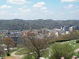
Charleston is the capital and most populous city of the U.S. state of West Virginia. Located at the confluence of the Elk and Kanawha rivers, the city had a population of 51,400 at the 2010 census and an estimated population of 47,215 in 2018. The Charleston metropolitan area as a whole had an estimated 211,037 residents in 2018. Charleston is the center of government, commerce, and industry for Kanawha County, of which it is the county seat.

Kanawha County is a county in the U.S. state of West Virginia. As of the 2010 census, the population was 193,063, making it West Virginia's most populous county. Its county seat is Charleston, the state capital. Kanawha County is part of the Charleston, WV Metropolitan Statistical Area.

Clendenin is a town in Kanawha County, West Virginia along the Elk River. The population was 1,227 at the 2010 census.

Sissonville is a census-designated place (CDP) in Kanawha County, West Virginia, along the Pocatalico River. The population was 4,028 at the 2010 census. Sissonville is located less than 14 miles north of Charleston.

Eleanor is a town in Putnam County, West Virginia, United States, along the Kanawha River. Its population was 1,518 at the 2010 census. The town was established as a New Deal project in the 1930s and named for Eleanor Roosevelt. Like other Franklin D. Roosevelt towns around the nation.

Teays Valley is a census-designated place (CDP) in Putnam County, West Virginia, United States. The place is divided into the two districts of Teays Valley and Scott Depot. The population was 13,175 at the 2010 census. Teays Valley is part of the Huntington-Ashland, WV-KY-OH, Metropolitan Statistical Area (MSA). As of the 2010 census, the MSA had a population of 287,702. New definitions from February 28, 2013 placed the population at 363,000.

Nitro is a city in Kanawha and Putnam counties in the State of West Virginia, United States, along the Kanawha River. The population was 7,178 at the 2010 census.
Confidence is an unincorporated community in Putnam County West Virginia located on WV 34. The community is served by Confidence Elementary School. Confidence is a part of the Huntington-Ashland Metropolitan Statistical Area (MSA). As of the 2010 census, the MSA had a population of 287,702. New definitions from February 28, 2013 placed the population at 363,000.
Hometown is a census-designated place (CDP) located along the Kanawha River on West Virginia Route 62 in Putnam County, West Virginia, United States. As of the 2010 census, its population was 668. Hometown has six streets that are intersected by one street. There is an elementary school. The red house on the left in the photo was constructed for Thomas M. Brown and Ella Mae Criner Brown in the early 1920s, and was the first house built at Hometown.

West Virginia Route 869 is a short, one mile (1.6 km) state highway in Putnam County, West Virginia that connects U.S. Route 35 and West Virginia Route 62 via the Lower Buffalo Bridge over the Kanawha River. The route itself is unsigned on the bridge. The road was commissioned in 1998 to provide an alternate route for the fragile Winfield Bridge for trucks hauling goods for the Toyota Plant in Buffalo.
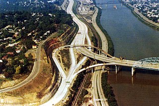
The roads of Charleston, West Virginia, include three major interstate highways, several U.S. highways and state routes, and numerous major thoroughfares.

Amherst-Plymouth Wildlife Management Area is a 7,061-acre (2,857 ha) protected area located in Putnam County, West Virginia. The site is along the banks of the Kanawha River and is popular for hunting Canada geese in the fall. Access is from West Virginia Route 62 between Bancroft and Hometown and from Manilla Creek Road and Heizer Creek Road off WV 62 north of Poca, West Virginia. Manilla Creek Road cuts across the north side of the Amherst-Plymouth WMA, and WV 62 follows the southern edge of the area alongside the Kanawha River.
Scott Depot is an unincorporated community in Putnam County, West Virginia, United States. It is located along Crooked Creek at and downstream from the creek's intersection with Teays Valley Road. The ZIP code is 25560. It is part of the census-designated place of Teays Valley which is a part of the Huntington-Ashland Metropolitan Statistical Area (MSA).
Raymond City is an unincorporated community in Putnam County, West Virginia, United States.

Poca High School, originally named "Pocatalico District High School", is a high school in Poca, West Virginia, United States. It serves the easternmost portion of Putnam County and is a part of the Putnam County Schools.
Robertsburg is an unincorporated community in Putnam County, West Virginia, United States. Robertsburg is located on the east bank of the Kanawha River along West Virginia Route 62, 3 miles (4.8 km) north-northeast of Buffalo. Robertsburg had a post office, which opened on August 6, 1900, and closed on May 10, 1997.
Putnam County Schools is a school district headquartered in Winfield, West Virginia. It serves Putnam County.

Arbuckle Magisterial District is one of ten magisterial districts in Mason County, West Virginia. The district was originally established as a civil township in 1863, and converted into a magisterial district in 1872. In 2010, Arbuckle District was home to 1,121 people.

West Virginia's 8th Senate district is one of 17 districts in the West Virginia Senate. It is currently represented by Democrats Glenn Jeffries and Richard Lindsay. All districts in the West Virginia Senate elect two members to staggered four-year terms.

