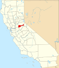
Red Corral, California

Last updated

Red Corral
USA California location map.svg
Red pog.svg
Red Corral
Position in California.
Coordinates: 38°24′42″N120°36′20″W / 38.41167°N 120.60556°W / 38.41167; -120.60556
Country Flag of the United States.svg  United States
State Flag of California.svg  California
County Amador
Area
[1]
  Total5.842 sq mi (15.131 km2)
  Land5.842 sq mi (15.131 km2)
  Water0 sq mi (0 km2)  0%
Elevation
[2]
2,710 ft (830 m)
Population
 (2010)
  Total1,413
  Density240/sq mi (93/km2)
Time zone UTC-8 (Pacific (PST))
  Summer (DST) UTC-7 (PDT)
GNIS feature ID2583119
U.S. Geological Survey Geographic Names Information System: Red Corral, California

Red Corral is a census-designated place in Amador County, California. Red Corral sits at an elevation of 2710 feet (826 m). The 2010 United States census reported Red Corral's population was 1,413.

Demographics

The 2010 United States Census [3] reported that Red Corral had a population of 1,413. The population density was 241.9 inhabitants per square mile (93.4/km2). The racial makeup of Red Corral was 1,259 (89.1%) White, 24 (1.7%) African American, 15 (1.1%) Native American, 12 (0.8%) Asian, 3 (0.2%) Pacific Islander, 33 (2.3%) from other races, and 67 (4.7%) from two or more races. Hispanic or Latino of any race were 147 persons (10.4%).

The Census reported that 1,349 people (95.5% of the population) lived in households, 2 (0.1%) lived in non-institutionalized group quarters, and 62 (4.4%) were institutionalized.

There were 573 households, out of which 144 (25.1%) had children under the age of 18 living in them, 323 (56.4%) were opposite-sex married couples living together, 47 (8.2%) had a female householder with no husband present, 32 (5.6%) had a male householder with no wife present. There were 42 (7.3%) unmarried opposite-sex partnerships, and 7 (1.2%) same-sex married couples or partnerships. 129 households (22.5%) were made up of individuals, and 51 (8.9%) had someone living alone who was 65 years of age or older. The average household size was 2.35. There were 402 families (70.2% of all households); the average family size was 2.67.

The population was spread out, with 247 people (17.5%) under the age of 18, 131 people (9.3%) aged 18 to 24, 239 people (16.9%) aged 25 to 44, 499 people (35.3%) aged 45 to 64, and 297 people (21.0%) who were 65 years of age or older. The median age was 48.9 years. For every 100 females, there were 106.9 males. For every 100 females age 18 and over, there were 110.1 males.

There were 679 housing units at an average density of 116.2 per square mile (44.9/km2), of which 573 were occupied, of which 458 (79.9%) were owner-occupied, and 115 (20.1%) were occupied by renters. The homeowner vacancy rate was 1.7%; the rental vacancy rate was 8.0%. 1,060 people (75.0% of the population) lived in owner-occupied housing units and 289 people (20.5%) lived in rental housing units.

Related Research Articles

<span class="mw-page-title-main">Desert View Highlands, California</span> Census designated place in California, United States

Desert View Highlands is a census-designated place (CDP) in Los Angeles County, California, United States. The population was 2,360 at the 2010 census, up from 2,337 at the 2000 census. It is surrounded by the City of Palmdale.

<span class="mw-page-title-main">Delleker, California</span> Census-designated place in California, United States

Delleker is a census-designated place (CDP) in Plumas County, California, USA. The population was 705 at the 2010 census, up from 674 at the 2000 census.

Maxwell is a census-designated place and farm community in Colusa County, California. It lies at an elevation of 92 feet. Located off Interstate 5, it is home to Maxwell High School. The main crop grown is rice, though a variety of others such as grapes, almonds, olives, squash, and sunflowers are grown as well. Its ZIP code is 95955 and its area code is 530. Maxwell's population was 1,103 at the 2010 census.

Buckhorn is a census-designated place in Amador County, California. Buckhorn sits at an elevation of 3,238 feet. The community is in ZIP code 95666 and area code 209. The 2010 United States census reported Buckhorn's population was 2,429.

<span class="mw-page-title-main">North San Juan, California</span> Census-designated place in California, United States

North San Juan is a census-designated place in Nevada County, California, United States, along State Route 49 on the San Juan Ridge in Gold Country. The zip code is 95960. The population was 269 at the 2010 census.

Bayview is a census-designated place in Contra Costa County, California. Bayview sits at an elevation of 36 feet. The 2010 United States census reported Bayview's population was 1,754. Prior to 2010, Bayview was part of the Bayview-Montalvin CDP and then separated into the two individual communities of Bayview and Montalvin Manor for the census.

Cold Springs is a census-designated place in El Dorado County, California. It is located 4 miles (6.4 km) west of Placerville, at an elevation of 1207 feet. It has a population of 446.

<span class="mw-page-title-main">Cherokee Strip, California</span> Census-designated place in California, United States

Cherokee Strip is a census-designated place in Kern County, California. It is located 2.5 miles (4 km) south-southeast of Shafter, at an elevation of 331 feet (101 m). The population was 206 at the 2010 census.

<span class="mw-page-title-main">Edmundson Acres, California</span> Census-designated place in California, United States

Edmundson Acres is a census-designated place in Kern County, California. It is located 1.25 miles (2 km) north-northeast of Arvin, at an elevation of 486 feet (148 m). Edmundson Acres' ZIP code is 93203. The population was 279 at the 2010 census.

Mexican Colony is a census-designated place in Kern County, California. It is located 2 miles (3.2 km) south of Shafter, at an elevation of 331 feet (101 m). The population was 283 at the 2020 census.

<span class="mw-page-title-main">Green Acres, California</span> Census-designated place in California, United States

Green Acres is a census-designated place in Riverside County, California. Green Acres sits at an elevation of 1,555 feet (474 m). The 2010 United States census reported Green Acres's population was 1,805.

<span class="mw-page-title-main">Litchfield, California</span> Census-designated place in California, United States

Litchfield is a census-designated place in Lassen County, California. It is located 15 miles (24 km) east of Susanville, at an elevation of 4,065 feet (1,239 m). Its population is 160 as of the 2020 census, down from 195 from the 2010 census.

Sultana is a census-designated place in Tulare County, California, United States. Sultana is 2.5 miles (4.0 km) east of Dinuba. Sultana has a post office with ZIP code 93666. The population was 775 at the 2010 census.

<span class="mw-page-title-main">Lindcove, California</span> Census-designated place in California, United States

Lindcove is a census-designated place in Tulare County, California, United States. The population was 406 at the 2010 census.

<span class="mw-page-title-main">Fort Washington, California</span> Census-designated place in California, United States

Fort Washington is a census-designated place in Fresno County, California. Fort Washington sits at an elevation of 249 feet (76 m). The 2010 United States census reported Fort Washington's population was 233.

<span class="mw-page-title-main">Hasley Canyon, California</span> Census-designated place in California, United States

Hasley Canyon is a census-designated place in the Sierra Pelona mountains of Los Angeles County, California. Hasley Canyon sits at an elevation of 1,765 feet (538 m). The 2010 United States census reported Hasley Canyon's population was 1,137.

Rose Hills is a census-designated place in Los Angeles County, California. Rose Hills sits at an elevation of 518 feet (158 m) above sea level. The 2010 United States census reported Rose Hills's population was 2,803.

Mesa Verde is a census-designated place in Riverside County, California. Mesa Verde sits at an elevation of 390 feet (120 m). The 2010 United States census reported Mesa Verde's population was 1,023.

Monson is a census-designated place (CDP) in Tulare County, California. Monson sits at an elevation of 325 feet (99 m). The 2010 United States census reported Monson's population was 188.

Panorama Heights is a census-designated place (CDP) in Tulare County, California. Panorama Heights sits at an elevation of 5,043 feet (1,537 m). The 2020 United States census reported Panorama Heights's population was 44, up from 41 at the 2010 census.

References

  1. "2010 Census U.S. Gazetteer Files – Places – California". United States Census Bureau.
  2. U.S. Geological Survey Geographic Names Information System: Red Corral, California
  3. "2010 Census Interactive Population Search: CA - Red Corral CDP". U.S. Census Bureau. Archived from the original on July 15, 2014. Retrieved July 12, 2014.