Amador City | |
---|---|
Nickname: The gold country's hidden nugget | |
Motto: "Essence of the California Gold & Wine Country" | |
Coordinates: 38°25′10″N120°49′27″W / 38.41944°N 120.82417°W | |
Country | United States |
State | California |
County | Amador |
Incorporated | June 2, 1915 [1] |
Government | |
• Mayor | Sandra Staples [2] |
• State Senate | Marie Alvarado-Gil (D) [3] |
• State Assembly | Joe Patterson (R) [4] |
• U. S. Congress | Tom McClintock (R) [5] |
Area | |
• Total | 0.31 sq mi (0.80 km2) |
• Land | 0.31 sq mi (0.80 km2) |
• Water | 0.00 sq mi (0.00 km2) 0% |
Elevation | 919 ft (280 m) |
Population (2020) | |
• Total | 200 |
• Density | 645.16/sq mi (249.46/km2) |
Time zone | UTC-8 (PST) |
• Summer (DST) | UTC-7 (PDT) |
ZIP code | 95601 |
Area code | 209 |
FIPS code | 06-01514 |
GNIS feature IDs | 1657922, 2409693 |
Website | www |
Amador City (formerly Amadore's Creek or South Amador) is a city in Amador County, California, United States. The population was 200 as of the 2020 Census, up from 185 in 2010, making it the least populous incorporated city in California. Amador City is also noted for being the smallest city in California by area.
Amador City is located at 38°25′10″N120°49′27″W / 38.41944°N 120.82417°W .
Only two miles (3.2 km) from Sutter Creek on Old Highway 49, Amador City is the state's smallest incorporated city by area. According to the United States Census Bureau, the city has a total area of 0.3 square miles (0.78 km2), all of which is land, making it the smallest city in California by size.
Amador City was originally settled in 1849 at what is now Turner Road and Amador Creek (an old wagon road between Drytown and Sutter Creek) by several groups of gold panners who were drawn to the area. One of the groups was the Sunol Group. The Sunol group included José María Amador. José María Amador panned the creek, but his primary success was providing supplies that he brought from his rancheria in the San Ramon area. José María Amador left the group after six months, returning to his rancheria. The rancheria had suffered during his absence, and he needed to care for his ailing wife. José María Amador must have made a significant impression among the other panners. The creek, city and County eventually carried the name "Amador", the city taking its name from the county. [8]
Early in 1851 gold quartz veins were discovered along the same creek but further west. Arrastras were brought to the area to crush the quartz. Shortly stamps mills were brought in to process the hard quartz that the gold veins were embedded in. By September two stamp mills were erected along Amador Creek. These stamp mills were so remarkable that it drew the attention of Eadweard Muybridge. He photographed the area and 3D images taken in 1851 were made of the stamp mills.
Amador City was incorporated as a city on June 2, 1915.
Census | Pop. | Note | %± |
---|---|---|---|
1880 | 824 | — | |
1890 | 984 | 19.4% | |
1920 | 377 | — | |
1930 | 171 | −54.6% | |
1940 | 249 | 45.6% | |
1950 | 151 | −39.4% | |
1960 | 202 | 33.8% | |
1970 | 156 | −22.8% | |
1980 | 136 | −12.8% | |
1990 | 196 | 44.1% | |
2000 | 196 | 0.0% | |
2010 | 185 | −5.6% | |
2020 | 200 | 8.1% | |
U.S. Decennial Census [9] |
At the 2010 census Amador City had a population of 185. The population density was 589.6 inhabitants per square mile (227.6/km2). The racial makeup of Amador City was 171 (92.4%) White, 0 (0.0%) African American, 4 (2.2%) Native American, 2 (1.1%) Asian, 0 (0.0%) Pacific Islander, 2 (1.1%) from other races, and 6 (3.2%) from two or more races. Hispanic or Latino of any race were 11 people (5.9%). [10]
The whole population lived in households, no one lived in non-institutionalized group quarters and no one was institutionalized.
There were 85 households, 22 (25.9%) had children under the age of 18 living in them, 35 (41.2%) were opposite-sex married couples living together, 9 (10.6%) had a female householder with no husband present, 3 (3.5%) had a male householder with no wife present. There were 10 (11.8%) unmarried opposite-sex partnerships, and 0 (0%) same-sex married couples or partnerships. 26 households (30.6%) were one person and 9 (10.6%) had someone living alone who was 65 or older. The average household size was 2.18. There were 47 families (55.3% of households); the average family size was 2.74.
The age distribution was 37 people (20.0%) under the age of 18, 18 people (9.7%) aged 18 to 24, 40 people (21.6%) aged 25 to 44, 65 people (35.1%) aged 45 to 64, and 25 people (13.5%) who were 65 or older. The median age was 43.5 years. For every 100 females, there were 94.7 males. For every 100 females age 18 and over, there were 100.0 males.
There were 108 housing units at an average density of 344.2 per square mile (132.9/km2), of which 85 were occupied, 54 (63.5%) by the owners and 31 (36.5%) by renters. The homeowner vacancy rate was 6.9%; the rental vacancy rate was 8.8%. 111 people (60.0% of the population) lived in owner-occupied housing units and 74 people (40.0%) lived in rental housing units.
At the 2000 census there were 196 people in 85 households, including 54 families, in the city. The population density was 601.7 inhabitants per square mile (232.3/km2). There were 91 housing units at an average density of 279.4 per square mile (107.9/km2). The racial makeup of the city was 90.82% White, 1.02% Native American, 4.08% from other races, and 4.08% from two or more races. Hispanic or Latino of any race were 9.18%. [11]
There were 85 households, 23.5% had children under the age of 18 living with them, 43.5% were married couples living together, 15.3% had a female householder with no husband present, and 35.3% were non-families. 27.1% of households were made up of individuals, and 10.6% had someone living alone who was 65 or older. The average household size was 2.31 and the average family size was 2.76.
The age distribution was 19.4% under the age of 18, 7.7% from 18 to 24, 27.0% from 25 to 44, 32.7% from 45 to 64, and 13.3% 65 or older. The median age was 42 years. For every 100 females, there were 92.2 males. For every 100 females age 18 and over, there were 100.0 males.
The median household income was $45,625 and the median family income was $39,861. Males had a median income of $30,313 versus $16,250 for females. The per capita income for the city was $17,963. About 14.0% of families and 22.9% of the population were below the poverty line, including 42.5% of those under the age of 18 and none of those 65 and older.
In the California State Legislature, Amador City is in the 8th Senate District , represented by Democrat Angelique Ashby, [3] and in the 5th Assembly District , represented by Republican Joe Patterson. [4]
In the United States House of Representatives, Amador City is in California's 5th congressional district , represented by Republican Tom McClintock. [5]
Amador City is within the sole school district in Amador County: Amador County Unified School District. [12]
There are currently no schools within Amador City's boundaries. The city is serviced by Amador High School, Ione Junior High and Sutter Creek Elementary.
Traveling the two blocks on Highway 49 the traveler can see signs of abandonment in this once thriving city, a contrast to the time when the placers and underground mines produced in abundance. An abandoned brick building stands next to the Fleehart Store, a beautiful reflection of the stone masonry of the time. Also on Main Street is the old Imperial Hotel, another example of the beautiful brickwork of California's past. [13] A bridge replacement project completed in 2014 has beautified and revitalized the center of the city, providing patio dining at the Imperial Hotel, new public restrooms and improved access to the many quaint shops, wine tasting rooms and purveyors of unique, tasty comestibles.
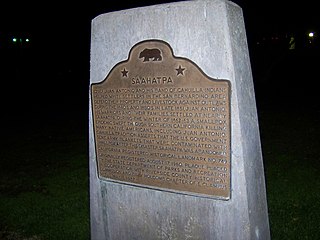
Amador County is a county located in the U.S. state of California, in the Sierra Nevada. As of the 2020 census, the population was 40,474. The county seat is Jackson. Amador County, located within California's Gold Country, is known as "The Heart of the Mother Lode". There is a substantial viticultural industry in the county.
Butte County is a county located in the northern central part of the U.S. state of California. In the 2020 census, its population was 211,632. The county seat is Oroville.
Kirkwood is an unincorporated community in Alpine and Amador counties, California, United States. Kirkwood's main attraction is the Kirkwood Mountain Resort. The town is accessible by State Route 88. Kirkwood is within the Eldorado National Forest. The population was 158 at the 2010 census. For statistical purposes, the United States Census Bureau has defined Kirkwood as a census-designated place (CDP).
Ione is a city in Amador County, California. As of the 2020 census the population is 5,141, which is a 35.1% decrease from the 2010 census. Once known as "Bedbug" and "Freeze Out," Ione was an important supply center on the main road to the Mother Lode and Southern Mines during the California Gold Rush.
Jackson is a city in and the county seat of Amador County, California. Its population was 4,651 at the 2010 census, up from 3,989 at the 2000 census. The city is accessible by both State Route 49 and State Route 88.
Plymouth is a city in Amador County, California, United States. The population was 1,005 at the 2010 census. The town was originally named Pokerville, when it was settled during the time of the gold rush. Plymouth is commonly now known as a "Gateway to Shenandoah Valley", a popular wine-producing region in the Sierra foothills. The Ione Band of Miwok Indians, a federally recognized tribe of Miwok people, is headquartered in Plymouth.
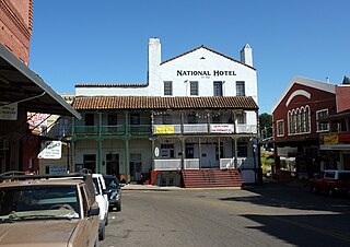
Sutter Creek is a city in Amador County, California, United States. The population was 2,501 at the 2010 census, up from 2,303 at the 2000 census. It is accessible via State Route 49.
Angels Camp, also known as City of Angels, is the only incorporated city in Calaveras County, California, United States. The population was 3,836 at the 2010 census, up from 3,004 at the 2000 census. It lies at an elevation of 1378 feet.
Bertsch–Oceanview is a census-designated place (CDP) in Del Norte County, California, United States. The community is located east of Crescent City, at an elevation of 20 feet (6.1 m), Bertsch–Oceanview has a total area of 5.9 square miles (15 km2) of which 5.5 square miles (14 km2) is land and 0.3 square miles (0.78 km2) is water. Its population is 2,520 as of the 2020 census, up from 2,436 from the 2010 census. The Elk Valley Rancheria Indian reservation is located within Bertsch–Oceanview.
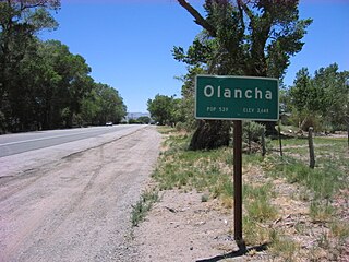
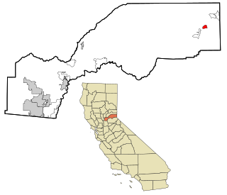
Olancha is a census designated place in Inyo County of the U.S. state of California. Olancha is located on U.S. Route 395 in California, 37 miles (60 km) south-southeast of Independence, at an elevation of 3658 feet. As of the 2010 census, the population was 192, up from 134 at the 2000 census.
Lower Lake is a census-designated place (CDP) in the southern Clear Lake region of Lake County, in northern California. Lower Lake is also an Indian rancheria of the Koi Nation people.
Dollar Point is a census-designated place (CDP) in Placer County, California, United States, along the northwest shore of Lake Tahoe. It is part of the Sacramento–Arden-Arcade–Roseville Metropolitan Statistical Area. The population was 1,215 at the 2010 census down from 1,539 at the 2000 census.
Calimesa is a city in Riverside County, California, United States in the Greater Los Angeles area. The population was 7,879 at the 2010 census, up from 7,139 at the 2000 census. It is situated in the San Gorgonio Pass.
Cloverdale is a city in Sonoma County, California, United States; it is both the westernmost and the northernmost city in the San Francisco Bay Area. The San Francisco and North Pacific Railroad reached Cloverdale in 1872. The Cloverdale Rancheria of Pomo Indians of California is headquartered there. The population was 8,618 at the 2010 census.
Sutter, formerly South Butte and Sutter City, is a census-designated place (CDP) in Sutter County, California, United States. It is part of the Yuba City Metropolitan Statistical Area within the Greater Sacramento CSA. The population as of the 2010 census was 2,904, up from 2,885 at the 2000 census.
Jamestown is a census-designated place (CDP) in Tuolumne County, California, United States. The population was 3,433 at the 2010 census, up from 3,017 at the 2000 census. Formerly a California Gold Rush town, Jamestown is a California Historical Landmark since March 16, 1949. It is the home of Railtown 1897 State Historic Park and the Sierra Railway, which operates steam passenger trains.
Montgomery Creek is a census-designated place in Shasta County, California, United States. Its population is 176 as of the 2020 census, up from 163 from the 2010 census. The town and associated creek were named after Zachariah Montgomery.
Scotts Mills is a city in Marion County, Oregon, United States. The population was 419 at the 2020 census. It is 2 miles (3 km) south of Marquam and Oregon Route 213, between Silverton and Molalla.
Mill City is a city in Linn and Marion counties in the U.S. state of Oregon on Oregon Route 22. The population was 1,971 at the 2020 census. It is on the North Santiam River, downstream from Detroit Lake.
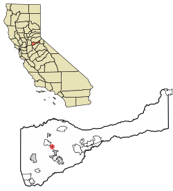
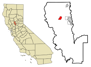
Buena Vista is a census-designated place in Amador County, California. It lies at an elevation of 295 feet. It is located 4 miles (6.4 km) south-southeast of Ione, at 38°17′40″N120°54′48″W. The community is in ZIP code 95640 and area code 209. The population was 429 at the 2010 census.