The California Gold Rush (1848–1855) was a gold rush that began on January 24, 1848, when gold was found by James W. Marshall at Sutter's Mill in Coloma, California. The news of gold brought approximately 300,000 people to California from the rest of the United States and abroad. The sudden influx of gold into the money supply reinvigorated the American economy; the sudden population increase allowed California to go rapidly to statehood in the Compromise of 1850. The Gold Rush had severe effects on Native Californians and accelerated the Native American population's decline from disease, starvation and the California genocide.

Amador County is a county located in the U.S. state of California, in the Sierra Nevada. As of the 2020 census, the population was 40,474. The county seat is Jackson. Amador County, located within California's Gold Country, is known as "The Heart of the Mother Lode". There is a substantial viticultural industry in the county.
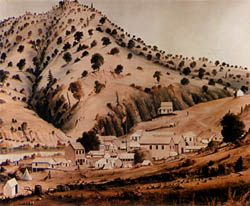
Mokelumne Hill is a census-designated place (CDP) in Calaveras County, California, United States. The population was 646 at the 2010 census, down from 774 at the 2000 census. It is commonly referred to as "Moke Hill" by locals. The town takes its name from the neighboring Mokelumne River, which in turn is Miwok for the "people of Mokel," the likely name of a Native American village in the area.

The Cosumnes River is a river in northern California in the United States. It rises on the western slope of the Sierra Nevada and flows approximately 52.5 miles (84.5 km) into the Central Valley, emptying into the Mokelumne River in the Sacramento-San Joaquin Delta.

State Route 49 is a north–south state highway in the U.S. state of California that passes through many historic mining communities of the 1849 California gold rush and it is known as the Golden Chain Highway. The highway's creation was lobbied by the Mother Lode Highway Association, a group of locals and historians seeking a single highway to connect many relevant locations along the Gold Rush to honor the 49ers. One of the bridges along SR 49 is named for the leader of the association, Archie Stevenot.

The Mokelumne River is a 95-mile (153 km)-long river in northern California in the United States. The river flows west from a rugged portion of the central Sierra Nevada into the Central Valley and ultimately the Sacramento–San Joaquin River Delta, where it empties into the San Joaquin River-Stockton Deepwater Shipping Channel. Together with its main tributary, the Cosumnes River, the Mokelumne drains 2,143 square miles (5,550 km2) in parts of five California counties. Measured to its farthest source at the head of the North Fork, the river stretches for 157 miles (253 km).

Dog Town is a gold rush era ghost town in Mono County, California. It is located at 38°10′13″N119°11′51″W, on Dog Creek, near the junction of Clearwater and Virginia Creeks, about 6 miles (10 km) south-southeast of Bridgeport, at an elevation of 7057 feet.

State Route 88 (SR 88), also known as the Carson Pass Highway, is a state highway in the U.S. state of California. It travels in an east–west direction from Stockton, in the San Joaquin Valley, to the Nevada state line, where it becomes Nevada State Route 88, eventually terminating at U.S. Route 395 (US 395). The highway is so named as it crests the Sierra Nevada at Carson Pass. The highway corridor predates the era of the automobile; the path over Carson pass was previously used for the California Trail and the Mormon Emigrant Trail. The mountainous portion of the route is included in the State Scenic Highway System.
Fiddletown is a census-designated place in Amador County, California. It lies at an elevation of 1683 feet. It is located at 38°30′14″N120°45′20″W. The town is registered as a California Historical Landmark and is listed in the National Register of Historic Places (NPS-78000655). The community is in ZIP code 95629 and area code 209. Fiddletown's population was 235 at the 2010 census.

Camanche is a former settlement in Calaveras County, California, United States. Located at an elevation of 220 feet, the town was once called Limerick, before it was renamed to Camanche in 1849. The settlement of Camanche is now submerged under Camanche Reservoir.

Woodbridge is a census-designated place in San Joaquin County, California. Woodbridge sits at an elevation of 43 feet (13 m). The 2010 United States census reported Woodbridge's population was 3,984. Founded in the 1850s, the town is listed as a California Historical Landmark.

Camanche Reservoir is an artificial lake in the San Joaquin Valley in California in the United States, at the juncture of Amador, Calaveras, and San Joaquin counties. Its waters are impounded by Camanche Dam, which was completed in 1963. Camanche Reservoir is a source of water for industrial and municipal purposes and also provides flood control.
Poverty Bar is a former settlement in Calaveras County, California, active from c. 1850s to 1862, and now covered by the waters of Camanche Reservoir. The nearest major town is Campo Seco, California.
Mokelumne City is a ghost town in San Joaquin County, California, United States. Mokelumne, established in 1850, was the second largest town in San Joaquin County until it was destroyed by the floods of 1862.
Middle Bar is a former mining town on the Mokelumne River in Amador County, California. It is a California Historical Landmark.

Dr. Charles Boarman was an American pioneer and frontier physician. He was among the original pioneers to settle in present-day Amador County, California, serving as its first county physician from 1863 until 1880, and was one of the founding members of the Society of California Pioneers. He was also the son of Rear Admiral Charles Boarman and uncle of fellow pioneer doctor Charles B. Harris.