Red River, Kewaunee County, Wisconsin

Last updated

Red River, Wisconsin
WIMap-doton-Red River.png
Location of Red River, Wisconsin
Coordinates: 44°37′57″N87°42′08″W / 44.63250°N 87.70222°W / 44.63250; -87.70222
Country Flag of the United States.svg  United States
State Flag of Wisconsin.svg  Wisconsin
County Kewaunee
Government
  Type Select board
   Chairman Jeff Dorner
   Supervisor #1Paul Dalebroux
   Supervisor #2Steve LeGrave
   Clerk Char Duckart
   Treasurer Ken Bouchonville
Area
  Total35.9 sq mi (93.0 km2)
  Land34.7 sq mi (90.0 km2)
  Water1.2 sq mi (3.0 km2)
Elevation
[1]
748 ft (228 m)
Population
 (2010)
  Total1,393
  Density40/sq mi (15.5/km2)
Time zone UTC-6 (Central (CST))
  Summer (DST) UTC-5 (CDT)
Area code 920
FIPS code 55-66700 [2]
GNIS feature ID1584003 [1]
Website www.townofredriver.org

Red River is a town in Kewaunee County, Wisconsin, United States. The population was 1,393 at the 2010 census, [3] down from 1,476 at the 2000 census. The unincorporated communities of Bay View, Duvall, Frog Station, Thiry Daems, and Tonet are located in the town. The census-designated place of Dyckesville is also located partially in the town.

Contents

Geography

The town is in the northwest corner of Kewaunee County; it is bordered to the north by Door County, to the west by Brown County, and to the northwest by Green Bay of Lake Michigan. According to the United States Census Bureau, the town has a total area of 35.9 square miles (93.0 km2), of which 34.7 square miles (90.0 km2) are land and 1.2 square miles (3.0 km2), or 3.23%, are water. [3]

Red River, Wisconsin.png

The town was once the site of a large Native American community and today contains multiple archeological sites. [4]

Demographics

As of the census [2] of 2000, there were 1,476 people, 528 households, and 419 families residing in the town. The population density was 42.5 people per square mile (16.4/km2). There were 601 housing units at an average density of 17.3 per square mile (6.7/km2). The racial makeup of the town was 98.98% White, 0.14% African American, 0.20% Native American, and 0.68% from two or more races. Hispanic or Latino of any race were 0.34% of the population.

There were 528 households, out of which 34.1% had children under the age of 18 living with them, 71.6% were married couples living together, 5.3% had a female householder with no husband present, and 20.5% were non-families. 15.9% of all households were made up of individuals, and 8.9% had someone living alone who was 65 years of age or older. The average household size was 2.79 and the average family size was 3.14.

In the town, the population was spread out, with 25.4% under the age of 18, 9.4% from 18 to 24, 27.6% from 25 to 44, 23.4% from 45 to 64, and 14.2% who were 65 years of age or older. The median age was 37 years. For every 100 females, there were 105.3 males. For every 100 females age 18 and over, there were 103.5 males.

The median income for a household in the town was $47,833, and the median income for a family was $55,250. Males had a median income of $35,571 versus $21,892 for females. The per capita income for the town was $19,673. About 3.5% of families and 6.1% of the population were below the poverty line, including 5.5% of those under age 18 and 9.8% of those age 65 or over.

Most Belgian-American towns

Red River is the second-most Belgian-American community in the United States, with 47% of its population reporting Belgian ancestry in 2000. [5] [6]

Related Research Articles

<span class="mw-page-title-main">Humboldt, Wisconsin</span> Town in Wisconsin, United States

Humboldt is a town in Brown County in the U.S. state of Wisconsin. The population was 1,311 at the 2010 census. The community name was chosen by Henry Fontaine.

<span class="mw-page-title-main">New Denmark, Wisconsin</span> Town in Wisconsin, United States

New Denmark is a town in Brown County in the U.S. state of Wisconsin. The population was 1,562 at the 2020 census. The town surrounds the village of Denmark but is separate from it. The unincorporated communities of Fontenoy and Langes Corners are located in the town. The unincorporated community of Buckman is also located partially in the town.

<span class="mw-page-title-main">Christiana, Dane County, Wisconsin</span> Town in Wisconsin, United States

The Town of Christiana is located in Dane County, Wisconsin, United States. The population was 1,235 at the 2020 census. It is named after Oslo, Norway and has one of the highest percentages of Norwegian ancestry in the United States. The unincorporated community of Utica and the village of Rockdale are located within the town. The village of Cambridge is located partly within the Town.

<span class="mw-page-title-main">Brussels, Wisconsin</span> Town in Wisconsin, United States

Brussels is a town in Door County, Wisconsin, United States. The population was 1,136 at the 2010 census. The unincorporated communities of Brussels, Misere, and Kolberg are located in the town. The unincorporated community of Rosiere is also located partially in the town.

<span class="mw-page-title-main">Union, Door County, Wisconsin</span> Town in Wisconsin, United States

The Town of Union is located in Door County, Wisconsin, United States. The population was 880 at the 2000 census. The unincorporated communities of Shoemaker Point and Namur are located in the town.

<span class="mw-page-title-main">Clyde, Wisconsin</span> Town in Wisconsin, United States

Clyde is a town in Iowa County, Wisconsin, United States. The population was 322 at the 2000 census. The unincorporated community of Clyde is located in the town. The town was named by Seth Champion, a director of the Kewaunee, Green Bay & Western railroad in the 1890s, for his son Clyde.

<span class="mw-page-title-main">Ahnapee, Wisconsin</span> Town in Wisconsin, United States

Ahnapee is a town in Kewaunee County, Wisconsin, United States, on the Ahnapee River. The population was 940 as of the 2010 census. The Ahnapee State Trail passes through the town of Ahnapee.

<span class="mw-page-title-main">Algoma, Wisconsin</span> City in Wisconsin, United States

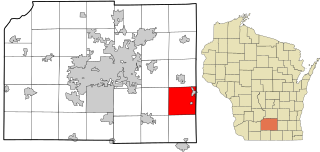
Algoma is a city in Kewaunee County in the U.S. state of Wisconsin. The population was 3,243 at the 2020 census. Algoma is part of the Green Bay Metropolitan Statistical Area.

<span class="mw-page-title-main">Carlton, Wisconsin</span> Town in Wisconsin, United States

Carlton is a town in Kewaunee County, Wisconsin, United States. The population was 1,014 at the 2010 census. Carlton is probably named for James Carlton, an early settler in the area.

<span class="mw-page-title-main">Franklin, Kewaunee County, Wisconsin</span> Town in Wisconsin, United States

Franklin is a town in Kewaunee County, Wisconsin, United States. The population was 993 at the 2010 census.

<span class="mw-page-title-main">Kewaunee, Wisconsin</span> City in Wisconsin, United States

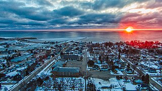
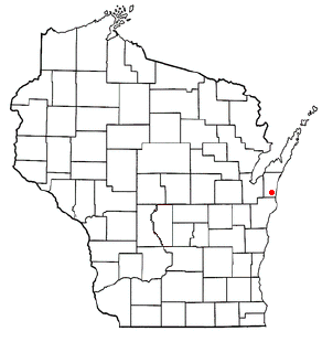
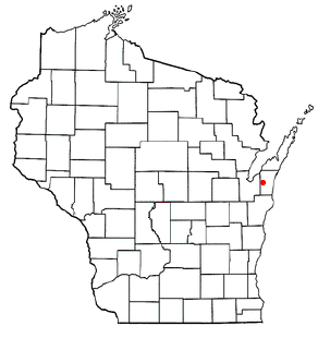
Kewaunee is a city in Kewaunee County, Wisconsin, United States. The population was 2,837 at the 2020 census. Located on the northwestern shore of Lake Michigan, the city is the county seat of Kewaunee County. Its Menominee name is Kewāneh, an archaic name for a species of duck.

<span class="mw-page-title-main">Lincoln, Kewaunee County, Wisconsin</span> Town in Wisconsin, United States

Lincoln is a town in Kewaunee County, Wisconsin, United States. The population was 948 at the 2010 census. The unincorporated communities of Lincoln, Gregorville, and Euren are in the town. The unincorporated communities of Rio Creek and Rosiere are also partially in the town.

<span class="mw-page-title-main">Montpelier, Wisconsin</span> Town in Wisconsin, United States

Montpelier is a town in Kewaunee County, Wisconsin, United States. The population was 1,306 at the 2010 census.

<span class="mw-page-title-main">Pierce, Wisconsin</span> Town in Wisconsin, United States

Pierce is a town in Kewaunee County, Wisconsin, United States. The population was 833 at the 2010 census.

<span class="mw-page-title-main">West Kewaunee, Wisconsin</span> Town in Wisconsin, United States

West Kewaunee is a town in Kewaunee County, Wisconsin, United States. The population was 1,296 at the 2010 census. The unincorporated communities of Birchwood, East Krok, and Krok are located in the town.

<span class="mw-page-title-main">Underhill, Wisconsin</span> Town in Wisconsin, United States

Underhill is a town in Oconto County, Wisconsin, United States. The population was 846 at the 2000 census.

<span class="mw-page-title-main">Green Bay (town), Wisconsin</span> Human settlement in Wisconsin, United States of America

Green Bay is a town in Brown County in the U.S. state of Wisconsin. The population was 2,035 at the 2010 census. The town is located several miles northeast of the city of Green Bay. The unincorporated community of Champion is located in the town, and the unincorporated communities of Dyckesville and New Franken are located partially in the town.

<span class="mw-page-title-main">Casco, Wisconsin</span> Village in Wisconsin, United States

Casco is a village in Kewaunee County, Wisconsin, United States. The population was 583 at the 2010 census. It is part of the Green Bay Metropolitan Statistical Area. The village is located within the Town of Casco. Casco is named after Casco Bay on the coast of Maine, the previous home of Edward Decker, an early logger in Kewaunee County.

Casco is a town in Kewaunee County, Wisconsin, United States. During the 2010 census of the town, the population recorded was at 1,165. The village of Casco, a separate municipality, is in the northwest part of the town, and the unincorporated communities of Clyde, Ryans Corner, Slovan, and Rio Creek are located in the town as well.

<span class="mw-page-title-main">Luxemburg (town), Wisconsin</span>

Luxemburg is a town in Kewaunee County, Wisconsin, United States. The population was 1,469 at the 2010 census. The village of Luxemburg, a separate municipality, is surrounded by the town. The unincorporated communities of Walhain and Casco Junction are in the town, and Neuern, Frog Station, and Tonet are partially in the town.

References

  1. 1 2 "US Board on Geographic Names". United States Geological Survey. October 25, 2007. Retrieved January 31, 2008.
  2. 1 2 "U.S. Census website". United States Census Bureau . Retrieved January 31, 2008.
  3. 1 2 "Geographic Identifiers: 2010 Census Summary File 1 (G001), Red River town, Kewaunee County, Wisconsin". American FactFinder. U.S. Census Bureau. Archived from the original on February 13, 2020. Retrieved August 9, 2019.
  4. 1994 Interim Report of Investigations of the State Highway 57 Improvement Project, Brown and Kewaunee Counties, Wisconsin by Weston, G.M., E.D. Benchley, B. Nansel, and R. Brubakerm, University of Wisconsin-Milwaukee Archaeological Research Laboratory Reports of Investigations No. 120. Report prepared for Wisconsin Department of Transportation, section on "Previously Reported Sites", page 18 and following (pdf page 23 and following)
  5. Belgian ancestry by city - ePodunk Archived June 4, 2009, at the Wayback Machine - Union forgotten !!
  6. "Union, Wisconsin - ePodunk". Archived from the original on March 18, 2012. Retrieved June 18, 2009.