Rewa Kantha Agency | |||||||
---|---|---|---|---|---|---|---|
Agency of British India | |||||||
1811–1937 | |||||||
Rewa Kantha Agency within Gujarat | |||||||
Area | |||||||
• 1901 | 12,877 km2 (4,972 sq mi) | ||||||
Population | |||||||
• 1901 | 479065 | ||||||
History | |||||||
History | |||||||
• Established | 1811 | ||||||
• Formation of the Baroda and Gujarat States Agency | 1937 | ||||||
|
Princely state |
---|
Individual residencies |
Agencies |
|
Lists |
Rewa Kantha was a political agency of British India, managing the relations (indirect rule) of the British government's Bombay Presidency with a collection of princely states. It stretched for about 150 miles between the plain of Gujarat and the hills of Malwa, from the Tapti River to the Mahi River crossing the Rewa (or Narmada) River, from which it takes its name. [1] [2]
The political agent, who was also District collector of the prant (British District) of the Panchmahal, resided at Godhra.
The native states came under British subsidiary alliances after the Third Anglo-Maratha War of the early 19th century. [3]
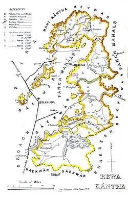
The total surface was 4,971.75 square miles, comprising 3,412 villages, with a population of 479,055, yielding 2,072,026 Rupeese state revenue and paying 147,826 Rupees tribute (mostly to the Gaikwar Baroda State).
In 1937 the princely states of the Rewa Kantha Agency were merged with Baroda State in order to form the Baroda and Gujarat States Agency, [4] which in turn merged in 1944 with the Western India States Agency as Baroda, Western India and Gujarat States Agency.
After the Independence of British India in 1947, split into India and Pakistan, the rulers of the states all agreed to accede to the Government of India and were integrated into Bombay State. Bombay state was split along linguistic lines in 1960, and Rewa Kantha became part of Gujarat, like Saurashtra State.
The number of separate states was 61, [2] mostly minor or petty states except for five. Many of them were under British influence; the largest one was Rajpipla. [2] [5]
The Agency also dealt with five first-class states named Chhota Udaipur State, Devgadh Bariya State, Santrampur, Lunawada State and Balasinor State. The total area of the states the agency related to was 12,877 km2 (4,972 sq mi). In 1901 their population was 479,065. Many of the inhabitants were Bhils and Kolis. [6]
(includes all the main states; in direct relations with the Political Agent at Godhra)
Non-salute states :
Only non-salute states: two geographical groups of minor or petty rural (e)states
(near Narmada River)
(near Mahi River; all paying tribute to the Gaekwar Baroda State):
In addition to those of Rewa Kantha Agency itself, revenue and/or court fee stamps were issued for the following native states :
Mahi Kantha was a political agency or collection of princely states in British India, within the Gujarat Division of Bombay Presidency. In 1933, the states of the Mahi Kantha Agency, except for Danta, were included in the Western India States Agency. The total area of the agency was 8,094 km2 (3,125 sq mi); the population in 1901 was 361,545.
Lunavada is a municipality in the Mahisagar district, formerly in the northern part of Gujarat state of India.
Palanpur Agency, also spelled Pahlunpore Agency, was a political agency or collection of princely states in British India, within the Gujarat Division of Bombay Presidency. In 1933, the native states of the Mahi Kantha Agency, except for Danta, were included in the Western India States Agency. The agency, headquartered at Palanpur, oversaw some 17 princely states and estates in the area, encompassing an area of 6393 square miles (16,558 km2) and a population, in 1901, of 467,271.
The Baroda Residency was one of the residencies of British India, managing the relations of the British with Baroda State between 1806 and the 1930s.
Idar State, also known as Edar, was a princely state located in present-day Gujarat state of India. During the British era, it was a part of the Mahi Kantha Agency, within the Gujarat Division of Bombay Presidency.
Gujarati Pashtuns/Pathans are a group of Pashtuns that have settled in the region of Gujarat in western India. They now form a distinct community of Gujarati and Urdu/Hindi speaking Muslims. They are distributed throughout the state, but live mainly in Ahmedabad, Rajkot, Junagadh, Surat, Bhavnagar, Panchamahal, Koth, Kotha, Borsad, Kheda, Banaskantha, Bharuch, Gandhinagar, Sabarkantha, Vadodara and Mehsana. They mainly speak Urdu/Hindi with many Hindustani and Pashto loanwords most of them have been Indianized so some may have Hindi/Gujarati as their first language as well, few elders in the community still speak Pashto. Common Tribes include Babi or Babai, Khan, Bangash, Durrani, and Yousafzai.
Saurashtra, also known as United State of Kathiawar, was a State of India that existed between 1948 and 1956, on Saurashtra alias Kathiawar peninsula, with Rajkot as its capital,
The Chhota Udaipur State or 'Princely State of Chhota Udaipur', was a princely state with its capital in Chhota Udaipur during the era of British India. The last ruler of Chhota Udaipur State signed the accession to join the Indian Union in 1948. Chhota Udaipur shares a history with Devgadh Baria and Rajpipla as one of the three princely states of eastern Gujarat.
Santrampur State is a former state located in the present-day state of Gujarat, India. It covered an area of approximately 1,367 km2 (528 sq mi) and was bounded on the north by the dominions of Dungarpur and Banswara in Rajputana. On the east was the sub division of Jhalod in the Panch Mahals. On the south it touched the small state of Sanjeli while on the west it was bounded by the State of Lunavada.The State enjoyed a hereditary salute of 9 gun and 11 gun local salute. The rulers of Santrampur are Parmar Rajputs. They claim descent from the Mahipavat branch of the famous Malwa dynasty.
The Kingdom of Rajpipla or Rajpipla State was a princely state, with full internal jurisdiction, in India ruled by the Gohil Rajput dynasty for over 600 years from around 1340 till 1948. It was the largest State, and the only first-class State, of the Rewa Kantha Agency.. Among Gujarat States, Rajpipla State was the second-largest after Baroda (Vadodara) in terms of size and importance. The Gohil Rajput dynasty of Rajpipla survived the onslaught of the Sultans of Ahmedabad and the Mughals during the mediaeval period, and the Gaekwars of Baroda and the British in the modern period, to emerge as a well-administered State with contemporary infrastructure, policies and practices by the time it was merged with the Union of India on 10 June 1948.
Baroda and Gujarat States Agency was a political agency of British India, managing the relations of the British government of the Bombay Presidency with a collection of princely states.
Lunavada State, also known as Lunawada State, was a princely state in India during the time of the British Raj. Its last ruler acceded to the Union of India on 10 June 1948.
The Baroda, Western India and Gujarat States Agency was a political agency of British India, managing the relations of the British government of the Bombay Presidency with a collection of princely states.
Jambughoda State, previously known as Narukot and Tokalpur state, was a small princely state in India during the time of the British Raj. Its last ruler acceded to the Union of India on 10 June 1948.
Sanjeli, cotila or sometimes known as Sanjeda Mehvassi, is a Hindu former petty princely state, located in the present Gujarat state in western India.
Alwa is a village and former Mehwal in Gujarat, western India.
Vakhtapur is a village and former Rajput non-salute princely state in Gujarat, western India.
Varnol Mal was a former non-salute princely state in Gujarat, western India.
Varnoli Nani is a village and former Rajput non-salute princely state in Gujarat, western India.
Raika (Reyka) is a village and former Mehwa in Vadodara Taluka of Vadodara district of Gujarat, western India.