Richland Township, Rice County, Minnesota

Last updated
Richland Township, Minnesota
Township
USA Minnesota location map.svg
Red pog.svg
Richland Township, Minnesota
Location within the state of Minnesota
Coordinates: 44°14′37″N93°5′47″W / 44.24361°N 93.09639°W / 44.24361; -93.09639 Coordinates: 44°14′37″N93°5′47″W / 44.24361°N 93.09639°W / 44.24361; -93.09639
Country United States
State Minnesota
County Rice
Area
  Total 36.1 sq mi (93.4 km2)
  Land 36.1 sq mi (93.4 km2)
  Water 0.0 sq mi (0.0 km2)
Elevation 1,171 ft (357 m)
Population (2000)
  Total 471
  Density 13.1/sq mi (5.0/km2)
Time zone Central (CST) (UTC-6)
  Summer (DST) CDT (UTC-5)
FIPS code 27-54250 [1]
GNIS feature ID 0665414 [2]

Richland Township is a township in Rice County, Minnesota, United States. The population was 471 at the 2000 census. The unincorporated communities of Moland and Ruskin are both partially located within the township. The unincorporated community of Epsom is located within Richland Township.

Rice County, Minnesota county in Minnesota, United States

Rice County is a county in the U.S. state of Minnesota. As of the 2010 census, the population was 64,142. Its county seat is Faribault.

Minnesota State of the United States of America

Minnesota is a state in the Upper Midwest and northern regions of the United States. Minnesota was admitted as the 32nd U.S. state on May 11, 1858, created from the eastern half of the Minnesota Territory. The state has a large number of lakes, and is known by the slogan the "Land of 10,000 Lakes". Its official motto is L'Étoile du Nord.

Moland, Minnesota Unincorporated community in Minnesota, United States

Moland is an unincorporated community in Rice and Steele counties in the U.S. state of Minnesota.

Contents

The first permanent settlement at Richland Township was made in 1854. [3]

Geography

According to the United States Census Bureau, the township has a total area of 36.1 square miles (93.4 km²), all of it land.

United States Census Bureau bureau of the United States responsible for the census and related statistics

The United States Census Bureau is a principal agency of the U.S. Federal Statistical System, responsible for producing data about the American people and economy. The Census Bureau is part of the U.S. Department of Commerce and its director is appointed by the President of the United States.

Demographics

As of the census [1] of 2000, there were 471 people, 162 households, and 131 families residing in the township. The population density was 13.1 people per square mile (5.0/km²). There were 166 housing units at an average density of 4.6/sq mi (1.8/km²). The racial makeup of the township was 99.58% White, and 0.42% from two or more races. Hispanic or Latino of any race were 1.49% of the population.

Census Acquiring and recording information about the members of a given population

A census is the procedure of systematically acquiring and recording information about the members of a given population. The term is used mostly in connection with national population and housing censuses; other common censuses include agriculture, business, and traffic censuses. The United Nations defines the essential features of population and housing censuses as "individual enumeration, universality within a defined territory, simultaneity and defined periodicity", and recommends that population censuses be taken at least every 10 years. United Nations recommendations also cover census topics to be collected, official definitions, classifications and other useful information to co-ordinate international practice.

Population density A measurement of population numbers per unit area or volume

Population density is a measurement of population per unit area or unit volume; it is a quantity of type number density. It is frequently applied to living organisms, and most of the time to humans. It is a key geographical term. In simple terms population density refers to the number of people living in an area per kilometer square.

There were 162 households out of which 37.7% had children under the age of 18 living with them, 74.1% were married couples living together, 1.2% had a female householder with no husband present, and 19.1% were non-families. 16.0% of all households were made up of individuals and 5.6% had someone living alone who was 65 years of age or older. The average household size was 2.91 and the average family size was 3.28.

Marriage social union or legal contract between people called spouses that creates kinship

Marriage, also called matrimony or wedlock, is a socially or ritually recognised union between spouses that establishes rights and obligations between those spouses, as well as between them and any resulting biological or adopted children and affinity. The definition of marriage varies around the world not only between cultures and between religions, but also throughout the history of any given culture and religion, evolving to both expand and constrict in who and what is encompassed, but typically it is principally an institution in which interpersonal relationships, usually sexual, are acknowledged or sanctioned. In some cultures, marriage is recommended or considered to be compulsory before pursuing any sexual activity. When defined broadly, marriage is considered a cultural universal. A marriage ceremony is known as a wedding.

In the township the population was spread out with 28.5% under the age of 18, 6.2% from 18 to 24, 32.9% from 25 to 44, 21.4% from 45 to 64, and 11.0% who were 65 years of age or older. The median age was 37 years. For every 100 females, there were 107.5 males. For every 100 females age 18 and over, there were 116.0 males.

The median income for a household in the township was $59,911, and the median income for a family was $63,375. Males had a median income of $35,809 versus $29,250 for females. The per capita income for the township was $18,956. None of the families and 2.7% of the population were living below the poverty line, including no under eighteens and 12.0% of those over 64.

Per capita income mean income of the people in an economic unit such as a country or city

Per capita income (PCI) or average income measures the average income earned per person in a given area in a specified year. It is calculated by dividing the area's total income by its total population.

Related Research Articles

Richland Township, Ogemaw County, Michigan Township in Michigan, United States

Richland Township is a civil township of Ogemaw County in the U.S. state of Michigan. The population was 956 at the 2000 census.

Richland Township, Saginaw County, Michigan Township in Michigan, United States

Richland Township is a civil township of Saginaw County in the U.S. state of Michigan. The population was 4,281 at the 2000 census. The 2010 Census places the population at 4,144.

Artichoke Township, Big Stone County, Minnesota Township in Minnesota, United States

Artichoke Township is a township in Big Stone County, Minnesota, United States. The population was 84 as of the 2000 census. Artichoke is also the name of an unincorporated hamlet within Artichoke Township.

Houston Township, Houston County, Minnesota Township in Minnesota, United States

Houston Township is a township in Houston County, Minnesota, United States. The population was 438 at the 2000 census.

Lynd Township, Lyon County, Minnesota Township in Minnesota, United States

Lynd Township is a township in Lyon County, Minnesota, United States. The population was 471 at the 2000 census.

Pembina Township, Mahnomen County, Minnesota Township in Minnesota, United States

Pembina Township is a township in Mahnomen County, Minnesota in the United States. The population was 471 at the 2000 census.

Rutland Township, Martin County, Minnesota Township in Minnesota, United States

Rutland Township is a township in Martin County, Minnesota, United States. The population was 472 at the 2000 census.

Andover Township, Polk County, Minnesota Township in Minnesota, United States

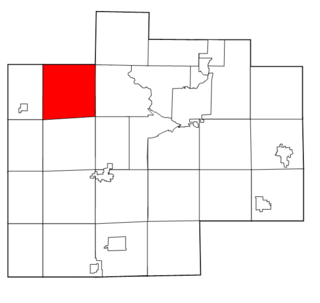
Andover Township is a township in Polk County, Minnesota, United States. Andover Township was organized in 1877. It is part of the Grand Forks-ND-MN Metropolitan Statistical Area. The population of the township was 154 at the 2000 census.

Hill River Township, Polk County, Minnesota Township in Minnesota, United States

Hill River Township is a township in Polk County, Minnesota, United States. It is part of the Grand Forks-ND-MN Metropolitan Statistical Area. The population was 162 at the 2000 census.

Russia Township, Polk County, Minnesota Township in Minnesota, United States

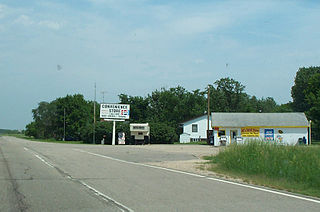
Russia Township is a township in Polk County, Minnesota, United States. It is part of the Grand Forks-ND-MN Metropolitan Statistical Area. The population of the township was 33 at the 2000 census. The unincorporated community of Greenview is located within Russia Township.

White Bear Lake Township, Pope County, Minnesota Township in Minnesota, United States

White Bear Lake Township is a township in Pope County, Minnesota, United States. The population was 440 at the 2000 census.

Dewey Township, Roseau County, Minnesota Township in Minnesota, United States

Dewey Township is a township in Roseau County, Minnesota, United States. The population was 114 at the 2000 census. Dewey is in the 7th congressional district of Minnesota and is represented by Democrat Collin Peterson.

Dieter Township, Roseau County, Minnesota Township in Minnesota, United States

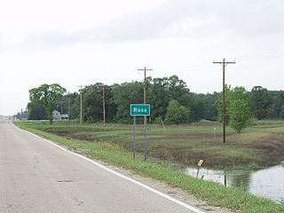
Dieter Township is a township in Roseau County, Minnesota, United States located along the Canada–US border. The population was 162 at the 2000 census. Dieter Township contains the unincorporated communities of Pinecreek and Ross.

Morcom Township, St. Louis County, Minnesota Township in Minnesota, United States

Morcom Township is a township in Saint Louis County, Minnesota, United States. The population was 94 at the 2010 census.

Monson Township, Traverse County, Minnesota Township in Minnesota, United States

Monson Township is a township in Traverse County, Minnesota, United States. The population was 162 at the 2000 census.

Highland Township, Wabasha County, Minnesota Township in Minnesota, United States

Highland Township is a township in Wabasha County, Minnesota, United States. The population was 471 at the 2000 census.

Pepin Township, Wabasha County, Minnesota Township in Minnesota, United States

Pepin Township is a township in Wabasha County, Minnesota, United States. The population was 471 at the 2000 census. The unincorporated communities of Maple Springs, Camp Lacupolis and Reads Landing are located within the township.

New Richland Township, Waseca County, Minnesota Township in Minnesota, United States

New Richland Township is a township in Waseca County, Minnesota, United States. The population was 497 at the 2000 census.

St. Mary Township, Waseca County, Minnesota Township in Minnesota, United States

St. Mary Township is a township in Waseca County, Minnesota, United States. The population was 504 at the 2000 census.

Enstrom Township, Roseau County, Minnesota Township in Minnesota, United States

Enstrom Township is a township in Roseau County, Minnesota, United States. The population was 580 at the 2000 census.

References

  1. 1 2 "American FactFinder". United States Census Bureau. Archived from the original on September 11, 2013. Retrieved 2008-01-31.
  2. "US Board on Geographic Names". United States Geological Survey. 2007-10-25. Retrieved 2008-01-31.
  3. Upham, Warren (1920). Minnesota Geographic Names: Their Origin and Historic Significance. Minnesota Historical Society. p. 463.