
The San Luis Valley is a region in south-central Colorado with a small portion overlapping into New Mexico. The Rio Grande with headwaters in the San Juan Mountains about seven miles east of Silverton, Colorado flows through the San Luis Valley and then south into New Mexico. It contains 6 counties and portions of 3 others. The San Luis Valley was ceded to the United States by Mexico following the Mexican–American War. Hispanic settlers began moving north and settling in the valley after the United States made a treaty with the Utes and established a fort. Prior to the Mexican war the Spanish and Mexican governments had reserved the valley to the Utes, their allies. During the 19th century Anglo settlers settled in the valley and engaged in mining, ranching, and irrigated agriculture. Today the valley has a diverse Anglo and Hispanic population.
Conejos County is a county located in the U.S. state of Colorado. As of the 2020 census, the population was 7,461. The county seat is the unincorporated community of Conejos.

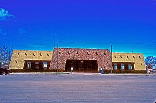
The Town of Antonito is a Statutory Town located in Conejos County, Colorado, United States. The town population was 647 at the 2020 United States Census.

The Sevier River is a 385-mile (620 km)-long river in the Great Basin of southwestern Utah in the United States. Originating west of Bryce Canyon National Park, the river flows north through a chain of high farming valleys and steep canyons along the west side of the Sevier Plateau, before turning southwest and terminating in the endorheic basin of Sevier Lake in the Sevier Desert. It is used extensively for irrigation along its course, with the consequence that Sevier Lake is usually dry.

The Kern River, originally Rio de San Felipe, later La Porciuncula, is a Wild and Scenic river in the U.S. state of California, approximately 165 miles (270 km) long. It drains an area of the southern Sierra Nevada mountains northeast of Bakersfield. Fed by snowmelt near Mount Whitney, the river passes through scenic canyons in the mountains and is a popular destination for whitewater rafting and kayaking. It is the southernmost major river system in the Sierra Nevada, and is the only major river in the Sierra that drains in a southerly direction.

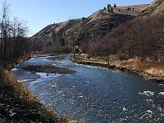
The Conejos River is a tributary of the Rio Grande, approximately 92.5 miles (148.9 km) long, in south-central Colorado in the United States. It drains a scenic area of the eastern San Juan Mountains west of the San Luis Valley.

The Clavey River is a tributary of the Tuolumne River in the Sierra Nevada, located in the Stanislaus National Forest and Tuolumne County, California. The river is 31.3 miles (50.4 km) long, and is one of the few undammed rivers on the western slope of the Sierra. Via the Tuolumne River, the Clavey is part of the San Joaquin River watershed.

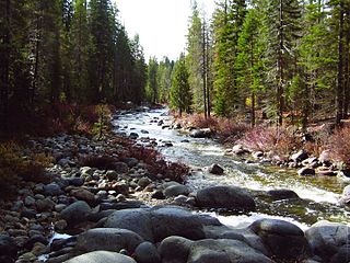
The Kaweah River is a river draining the southern Sierra Nevada in Tulare County, California in the United States. Fed primarily by high elevation snowmelt along the Great Western Divide, the Kaweah begins as four forks in Sequoia National Park, where the watershed is noted for its alpine scenery and its dense concentrations of giant sequoias, the largest trees on Earth. It then flows in a southwest direction to Lake Kaweah – the only major reservoir on the river – and into the San Joaquin Valley, where it diverges into multiple channels across an alluvial plain around Visalia. With its Middle Fork headwaters starting at almost 13,000 feet (4,000 m) above sea level, the river has a vertical drop of nearly two and a half miles (4.0 km) on its short run to the San Joaquin Valley, making it one of the steepest river drainages in the United States. Although the main stem of the Kaweah is only 33.6 miles (54.1 km) long, its total length including headwaters and lower branches is nearly 100 miles (160 km).

The Rio Chama, a major tributary river of the Rio Grande, is located in the U.S. states of Colorado and New Mexico. The river is about 130 miles (210 km) long altogether. From its source to El Vado Dam its length is about 50 miles (80 km), from El Vado Dam to Abiquiu Dam is about 51 miles (82 km), and from Abiquiu Dam to its confluence with the Rio Grande is about 34 miles (55 km).
The Touchet River is a 55-mile (89 km) tributary of the Walla Walla River in southeastern Washington in the United States. The Touchet River drains an area of about 740 square miles (1,900 km2) in Columbia County and Walla Walla County.

The Jemez River is a tributary of the Rio Grande in eastern Sandoval County, New Mexico, United States.

The Middle Fork Kings River is a 37.2-mile (59.9 km) tributary of the Kings River in Kings Canyon National Park, California, in the southern Sierra Nevada. Draining 318 square miles (820 km2) – almost all of it wilderness – the Middle Fork is one of the largest wholly undeveloped watersheds in the state, with no dams or paved roads within its basin. The entire length of the Middle Fork is designated a National Wild and Scenic River.

The South Fork Kings River is a 44.1-mile (71.0 km) tributary of the Kings River in the Sierra Nevada of Fresno County, California. The river forms part of Kings Canyon, the namesake of Kings Canyon National Park and one of the deepest canyons in North America with a maximum relief of 8,200 feet (2,500 m) from rim to river.

The Little Kern River is a 24.4 miles (39.3 km) long major tributary of the upper Kern River in the Sequoia National Forest, in the southern Sierra Nevada, California. It is one of three streams, along with Volcano Creek and Golden Trout Creek, that harbor beautiful golden trout.

Deep Creek is a tributary of the Mojave River, 23.4 miles (37.7 km) long, in San Bernardino County, California.
Dinkey Creek is a large stream in the southern Sierra Nevada, in Fresno County, California. The creek is 29.2 miles (47.0 km) long, flowing undammed in a southerly direction through the Sierra National Forest. It is a tributary of the North Fork Kings River, in turn part of the Kings River system which drains into the de-watered Tulare Lake bed.

Arroyo Grande Creek is a major stream in San Luis Obispo County on the Central Coast of California. The creek flows 22 miles (35 km) in a southwesterly direction, from the Santa Lucia Range to the Pacific Ocean. It is a major source of water supply for southern San Luis Obispo County.

The Tusas Mountains are a mountain range in northern New Mexico, extending briefly into southern Colorado. They are considered the southeasternmost part of the San Juan Mountains. Grouse Mesa, 11,407 feet (3,477 m), is the highest peak in the range. The mountains are located to the west of Taos and northwest of Santa Fe. The Tusas Mountains are a wide region of upland mesas and gently sloping mountains, dissected in places by deep canyons.

The San Luis Hills are a group of small mountain ranges in Conejos and Costilla counties in the San Luis Valley in southern Colorado. The individual mountain ranges that make up the San Luis Hills include the Fairy Hills, the Brownie Hills, the Piñon Hills, and the South Piñon Hills. The San Luis Hills' highest point is Flat Top, elevation 9,206 feet
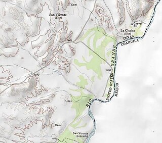
San Vicente was a village located in Brewster County, Texas within the protruding big bend of the Rio Grandé river. The village was geographically 1.5 miles (2.4 km) north of the San Vicente Crossing in present-day Big Bend National Park. The uninhabited site provides a panoramic view of the Chisos Mountains and the Sierra San Vicente migrating into Northern Mexico.
