
The San Luis Valley is a region in south-central Colorado with a small portion overlapping into New Mexico. The valley is approximately 122 miles (196 km) long and 74 miles (119 km) wide, extending from the Continental Divide on the northwest rim into New Mexico on the south. It contains 6 counties and portions of 3 others. It is an extensive high-elevation depositional basin of approximately 8,000 square miles (21,000 km2) with an average elevation of 7,664 feet (2,336 m) above sea level. The valley is a section of the Rio Grande Rift and is drained to the south by the Rio Grande, which rises in the San Juan Mountains to the west of the valley and flows south into New Mexico. The San Luis Valley has a cold desert climate but has substantial water resources from the Rio Grande and groundwater.

Costilla County is a county located in the U.S. state of Colorado. As of the 2020 census, the population was 3,499. The county seat is San Luis, the oldest continuously occupied town in Colorado.

Alamosa County is a county located in the U.S. state of Colorado. As of the 2020 census, the population was 16,376. The county seat is Alamosa. The county name is the Spanish language word for a grove of cottonwood trees.
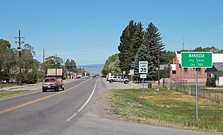
Founded in 1851, the Town of Manassa is a Statutory Town and is the most populous municipality in Conejos County, Colorado, United States. The town population was 947 at the 2020 United States Census.

San Luis is a statutory town that is the county seat and the most populous town of Costilla County, Colorado, United States. Formerly known as San Luis de la Culebra, it is the oldest continuously occupied town in Colorado. The population was 598 at the 2020 census.

Great Sand Dunes National Park and Preserve is an American national park that conserves an area of large sand dunes up to 750 feet (230 m) tall on the eastern edge of the San Luis Valley, and an adjacent national preserve in the Sangre de Cristo Range, in south-central Colorado, United States. The park was originally designated Great Sand Dunes National Monument on March 17, 1932, by President Herbert Hoover. The original boundaries protected an area of 35,528 acres. A boundary change and redesignation as a national park and preserve was authorized on November 22, 2000, and then established on September 24, 2004. The park encompasses 107,342 acres while the preserve protects an additional 41,686 acres for a total of 149,028 acres. The recreational visitor total was 527,546 in 2019.

The Sangre de Cristo Mountains are the southernmost subrange of the Rocky Mountains. They are located in southern Colorado and northern New Mexico in the United States. The mountains run from Poncha Pass in South-Central Colorado, trending southeast and south, ending at Glorieta Pass, southeast of Santa Fe, New Mexico. The mountains contain a number of fourteen thousand foot peaks in the Colorado portion, as well as several peaks in New Mexico which are over thirteen thousand feet.
Blanca Peak is the fourth highest summit of the Rocky Mountains of North America and the U.S. state of Colorado. The ultra-prominent 14,351-foot (4,374 m) peak is the highest summit of the Sierra Blanca Massif, the Sangre de Cristo Range, and the Sangre de Cristo Mountains. The fourteener is located 9.6 miles (15.5 km) north by east of the Town of Blanca, on the drainage divide separating Rio Grande National Forest and Alamosa County from the Sangre de Cristo Land Grant and Costilla County. The summit is the highest point of both counties and the entire drainage basin of the Rio Grande. Below the steep North Face of Blanca Peak two live Glaciers once developed, until extinction sometime after 1903. North & South Blanca Glaciers were located at 37° 35N.,longitude 105° 28W. Blanca Peak is higher than any point in the United States east of its longitude.

Chama is an unincorporated community and U.S. Post Office in Costilla County, Colorado, United States. The ZIP Code of the Chama Post Office is 81126.

The Colorado Department of Highways is the antecedent of today's Colorado Department of Transportation.

Rio Culebra is a river or creek in Costilla County, Colorado. The Rio Culebra rises in the Sangre de Cristo Mountains and is 48 km (30 mi) long. It empties into the Rio Grande west of the town of San Luis. The region around San Luis features extensive agriculture made possible by irrigation water from the river. Sometimes called the "Culebra Basin" this area is known for the extensive irrigation canals called acequias built by its Hispanic settlers in the 19th century and still in use in the 21st century

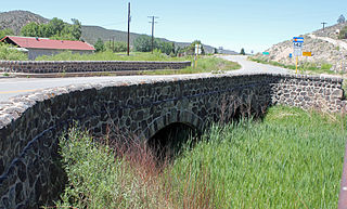
The San Luis Bridge, also known as State Bridge or Bridge over Culebra Creek, is a historic open spandrel arch bridge that crosses Culebra Creek in San Luis, Colorado. It was built in 1911 as a road bridge, but now serves pedestrian traffic. It is listed on the National Register of Historic Places.
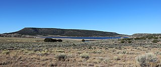
Mountain Home Reservoir is a reservoir and state wildlife area in Costilla County, Colorado, near Fort Garland. Frozen in winter, the reservoir lies at 2,483 meters elevation on the western slope of the Culebra Range of the Sangre de Cristo Mountains in southern Colorado.
The Rito Seco Creek Culvert, in San Luis, Colorado, was built as a Works Progress Administration project. It was listed on the National Register of Historic Places in 2002.

Lake Alamosa is a former lake in Colorado. It existed from the Pliocene to the middle Pleistocene in the San Luis Valley, fed by glacial meltwater from surrounding mountain ranges. Water levels waxed and waned with the glacial stages until at highstand the lake reached an elevation of 2,335 meters (7,661 ft) and probably a surface of over 4,000 square kilometers (1,500 sq mi), but only sparse remains of the former waterbody are visible today. The existence of the lake was postulated in the early 19th century and eventually proven in the early 20th century.

The San Luis Hills are a group of small mountain ranges in Conejos and Costilla counties in the San Luis Valley in southern Colorado. The individual mountain ranges that make up the San Luis Hills include the Fairy Hills, the Brownie Hills, the Piñon Hills, and the South Piñon Hills. The San Luis Hills' highest point is Flat Top, elevation 9,206 feet
The Los Caminos Antiguos Scenic and Historic Byway is a 129-mile (208 km) Back Country Byway and Colorado Scenic and Historic Byway located in Alamosa, Conejos, and Costilla counties, Colorado, USA. The byway explores the historic San Luis Valley of south-central Colorado including Great Sand Dunes National Park and Preserve; the Old Spanish National Historic Trail; historic Fort Garland, San Luis (San Luis de la Culebra), the oldest town in Colorado; and the Cumbres and Toltec Scenic Railroad.
The Sangre de Cristo Land Grant in the San Luis Valley of southern Colorado and northern New Mexico consists of 1,000,000 acres (4,000 km2) of mostly arid land. It was awarded by the government of New Mexico to the Beaubien family in 1843. The land grant was originally settled by Hispanics from New Mexico. Since the incorporation of the area of the grant into the United States in 1848, legal disputes between the descendants of the Hispanic settlers and Anglo ranchers about ownership of and access to some of the land in the grant area have been frequent and continued into the 21st century.

