
The River Dearne South Yorkshire, England flows roughly east for more than 30 kilometres (19 mi), from its source just inside West Yorkshire. It flows through Denby Dale, Clayton West, Darton, Barnsley, Darfield, Wath upon Dearne, Bolton on Dearne, Adwick upon Dearne and Mexborough to its confluence with the River Don at Denaby Main. Its main tributary is the River Dove, which joins it at Darfield. The river was one of those affected by the 2007 United Kingdom floods.

Eden was a local government district in Cumbria, England, based at Penrith Town Hall in Penrith. It was named after the River Eden, which flowed north through the district toward Carlisle. Its population of 49,777 at the 2001 census, increased to 52,564 at the 2011 Census. A 2019 estimate was 53,253. In July 2021 it was announced that, in April 2023, Cumbria would be divided into two unitary authorities. On 1 April 2023, Eden District Council was abolished and its functions transferred to the new authority Westmorland and Furness, which also covers the former districts of Barrow-in-Furness and South Lakeland.
The River Eden is a river that flows through Westmorland and Cumberland, England, on its way to the Solway Firth. It gave its name to a now-abolished former local government council area, Eden District, in its upper reaches, an area now part of Westmorland and Furness unitary authority area. The lower reaches of the River Eden now pass through the unitary authority area of Cumberland Council.
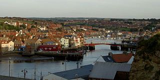
The River Esk is a river in North Yorkshire, England that empties into the North Sea at Whitby after a course of around 28 miles (45 km) through its valley of Eskdale. The river's name is derived from the Brythonic word "isca" meaning "water". The Esk is the only major river in Yorkshire that flows directly into the North Sea; all other watercourses defined as being major rivers by the Environment Agency, either flow to the North Sea via the River Tees or the Humber Estuary.

The River Esk, sometimes called the Cumbrian Esk, is a river in Cumbria, England. It flows for approximately 25 km from its source in the Scafells range of mountains to its estuary at Ravenglass. The valley it flows through is known as Eskdale. It is one of two Rivers Esk in Cumbria, and not to be confused with the Border Esk which flows into Cumbria from Scotland.

Costa Beck is a small river in the Ryedale district of North Yorkshire, England. It also lends its name to an archaeological site.

West Beck is the common name given to the upper section of the old River Hull, as it rises in the foothills of the Yorkshire Wolds. After reaching Frodingham Beck at Emmotland, it becomes called the River Hull. It is noteworthy for being the most northerly chalk stream in England. It provides fly fishing for wild brown trout and grayling.

The Ellen is a river in the English county of Cumbria, flowing from Skiddaw in the Northern Fells to the Solway Firth at Maryport. It was historically in the county of Cumberland. It is approximately 25 miles (40.2 km) in length.
The River Wampool is a river flowing through north western Cumbria in England. It is in the Waver and Wampool catchment which includes the towns of Silloth and Wigton.

The River Ehen is a river in Cumbria, England.

King's Meaburn is a small village and civil parish in Cumbria, England. It is located 5 miles (8.0 km) from Appleby-in-Westmorland and 10 miles (16 km) from Penrith, situated in the valley of the River Lyvennet. The river flows just to the west of the village and was crossed by a ford on the road to Newby and Morland. According to the 2001 census, the parish had a population of 105, which increased to 135 according to the 2011 Census.
Crosby Ravensworth is a village and civil parish in the Eden district of Cumbria, England. The village is about 4 miles (6.4 km) east of the M6 motorway, and Shap. At the 2001 census the parish had a population of 538, decreasing to 517 at the 2011 Census.

Maulds Meaburn is a village in Cumbria, England. It is located in the Lyvennet Valley and Yorkshire Dales National Park and is 13 miles from Penrith. Its origins are connected with the nearby village King's Meaburn.

Flass, also called Flass House, is a large Grade II* listed house near the village of Maulds Meaburn, Cumbria, England. It was built in the 19th century in the Neo-Palladian style by the tea and opium traders Lancelot and Wilkinson Dent of Dent & Co. It remained in the hands of the Dent family until 1972, when it was sold to the historian Frank Welsh. It was sold again in 1982 to the solicitor Malcolm Whiteside, who temporarily ran the property as a care home. In 2000, the musician Christine Holmes and her husband Paul Davies bought the property. The pair divorced, and, in 2012, it was discovered that the property had been used by a criminal gang for the cultivation of cannabis. Six men, including Davies, were jailed in 2015. Holmes took control of the property, which was sold at auction in 2019.
Crosby Ravensworth is a civil parish in the Eden District, Cumbria, England. It contains 53 buildings that are recorded in the National Heritage List for England. Of these, one is listed at Grade I, the highest of the three grades, six are at Grade II*, the middle grade, and the others are at Grade II, the lowest grade. The parish contains the villages of Crosby Ravensworth, Maulds Meaburn, Reagill, the small settlement of Oddendale, and the surrounding countryside. Most of the listed buildings are country houses, smaller houses, and associated structures, farmhouses and farm buildings. The other listed buildings include a church and items in the churchyard, bridges, monuments, a village hall, and a parish boundary stone.

The Sea Cut (Scalby Beck) is a small river that enters the North Sea at Scalby Mills, Scarborough, North Yorkshire, England. The beck is fed from local streams in Scalby, Newby and Burniston and other watercourses draining off the nearby hills. It is also a bypass channel for the upper reaches of the River Derwent when it is under flood conditions.

Pickering Beck is a river that runs for over 18 miles (29 km) from its source in the North York Moors National Park through the town of Pickering and on to its confluence with Costa Beck at Kirby Misperton. It is a meandering river that is fed by numerous named and unnamed becks and streams which flow over sandstone and limestone beds and an alluvia of sand, clay silt and gravel. The beck is known for flooding and in recent times has been a beneficiary of funding and experimental flood protection schemes.

The River Burn is a river that flows wholly within North Yorkshire, England. The river starts as several small streams on Masham Moor and drains Colsterdale flowing eastwards before emptying into the River Ure just south of Masham. Conservation work on removing a weir, and introducing fish to the river in 2016, has meant that salmon have been recorded spawning in the river for the first time in over 100 years.

The Orton Fells is an upland area in Northern England, mostly consisting of limestone hills, plateaus and moorlands. Historically in Westmorland, the area lies within the modern county of Cumbria and is bounded by the Lake District to the west, the Eden Valley to the north and east, and the Yorkshire Dales and Howgill Fells to the south. The area mostly falls within the boundaries of the Yorkshire Dales National Park while a small part of the western fells is in the Lake District National Park. The fells are one of 159 National Character Areas defined by Natural England.

Skelton Beck is a small river in North Yorkshire, England. The beck only runs for 23 kilometres (14 mi) and feeds directly into the North Sea on the south side of Saltburn beach. The beck is noted for occasionally being polluted with wastewater from the abandoned ironstone workings in its headwaters.

