Roads in Israel

Last updated
Ayalon Highway near Tel Aviv Littleuni 13.jpg
Ayalon Highway near Tel Aviv
Road sign in Israel, with Israel's official language (Hebrew) as well as Arabic and English markings Beit Hashita.jpg
Road sign in Israel, with Israel's official language (Hebrew) as well as Arabic and English markings

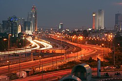
Israel has a well-developed road network spanning the entire country. This network is undergoing constant improvement and expansion to accommodate the rising number of vehicles on its roadways, reduce commute times, and facilitate the outward de-concentration of residential, business, and government centers north and south of the country's center.

Contents

The National Roads Authority of Israel

Founded in 2003, the National Roads Authority of Israel plans, develops and maintains most of the inter-city roads in Israel. This authority also builds and plans interchanges, bridges etc. The road length that is under control of the authority is approximately 6,500 km long. Some inter-city routes are built by concessionaires and private companies in exchange for payment from the government, outside of the responsibility of the National Roads Authority, while others are developed and maintained by regional or municipal road authorities. The National Roads Authority of Israel took over the responsibility for most of Israel's intercity roads from the Public Works Department (PWD) in 2003. Modern road development in the country began during the British Mandate of Palestine. In 1921 the Mandate government founded an engineering branch for carrying out infrastructure projects, this later became the PWD, which later evolved into the National Roads Authority of Israel. In ancient Israel the development of an unpaved yet extensive road system has been attributed to efforts under King Solomon (Herzog and Gichon, 1978, p. 121).

Numbering of the roads

Highway 1: from Jerusalem to Tel Aviv The route from Jerusalem to Ashdod 01.jpg
Highway 1: from Jerusalem to Tel Aviv
Route 225 descending into Makhtesh Gadol. HWY 225 Israel.JPG
Route 225 descending into Makhtesh Gadol.

Roads in Israel are categorized as national roads, inter-city roads, regional roads and local roads:

ISR-FW-6.svg National roads – numbered with one digit (e.g. Route 1, Jerusalem-Tel Aviv)

ISR-HW-10.svg Inter-City roads – numbered with two digits (e.g. Highway 10 (Israel) – Route 10)

ISR-HW-293.svg Regional roads – numbered with three digits (e.g. Route 293)

ISR-HW-4111.svg Local roads – numbered with four digits (e.g. Route 8900, Safed-Rosh Pinna)

Often even numbered roads run from south to north (e.g. Highway 2, Tel Aviv-Haifa). Odd numbered roads go from west to east (e.g. Highway 5, the Mediterranean Sea coast to Samaria).

As a general rule, for highways with the same number of digits, numbers from south to north, and from west to east. Thus, Highways 12 and 13 are located in the far south of Israel, whereas Highways 98 and 99 meet near Mount Hermon in the far northeast of the country. There are some exceptions to this: for example, Highway 1 runs mostly north of Highway 3.

List of highways in Israel

There are 47 designated highways in Israel, of those six are Freeways, six are partially freeways and partially expressways and 35 are expressways. Two of the expressways are divided into separate sections as a result of an IDF decree forbidding Israelis from traveling on certain stretches of these highways.

Related Research Articles

<span class="mw-page-title-main">Transport in Israel</span>

Transportation in Israel is based mainly on private motor vehicles and bus service and an expanding railway network. A lack of inland waterways and the small size of the country make air and water transport of only minor importance in domestic transportation, but they are vitally important for Israel's international transport links. Demands of population growth, political factors, the Israel Defense Forces, tourism and increased traffic set the pace for all sectors, being a major driver in the mobility transition towards railways and public transit while moving away from motorized road transport. All facets of transportation in Israel are under the supervision of the Ministry of Transport and Road Safety.

<span class="mw-page-title-main">Gush Dan</span> Metropolitan area in Israel

Gush Dan or Tel Aviv metropolitan area is a conurbation in Israel, located along the country's Mediterranean coastline. There is no single formal definition of Gush Dan though the term is in frequent use by both governmental bodies and the general public. It ranges from combining Tel Aviv with cities that form urban continuum with it to the entire areas from both the Tel Aviv and the Central District or sometimes the whole Metropolitan Area of Tel Aviv. which includes a small part of the Southern District as well. Gush Dan is the largest conurbation and metropolitan area in Israel, with the metropolitan area having an estimated population of 4,156,900 residents, 89% of whom are Israeli Jews.

<span class="mw-page-title-main">Highways in Australia</span>

Highways in Australia are generally high capacity roads managed by state and territory government agencies, though Australia's federal government contributes funding for important links between capital cities and major regional centres. Prior to European settlement, the earliest needs for trade and travel were met by narrow bush tracks, used by tribes of Indigenous Australians. The formal construction of roads began in 1788, after the founding of the colony of New South Wales, and a network of three major roads across the colony emerged by the 1820s. Similar road networks were established in the other colonies of Australia. Road construction programs in the early 19th century were generally underfunded, as they were dependent on government budgets, loans, and tolls; while there was a huge increase in road usage, due to the Australian gold rushes. Local government authorities, often known as Road Boards, were therefore established to be primarily responsible for funding and undertaking road construction and maintenance. The early 1900s saw both the increasingly widespread use of motorised transportation, and the creation of state road authorities in each state, between 1913 and 1926. These authorities managed each state's road network, with the main arterial roads controlled and maintained by the state, and other roads remaining the responsibility of local governments. The federal government became involved in road funding in the 1920s, distributing funding to the states. The depression of the 1930s slowed the funding and development of the major road network until the onset on World War II. Supply roads leading to the north of the country were considered vital, resulting in the construction of Barkly, Stuart, and Eyre Highways.

<span class="mw-page-title-main">Dual carriageway</span> Type of road

A dual carriageway (BrE) or a divided highway (AmE) is a class of highway with carriageways for traffic travelling in opposite directions separated by a central reservation (BrE) or median (AmE). Roads with two or more carriageways which are designed to higher standards with controlled access are generally classed as motorways, freeways, etc., rather than dual carriageways.

<span class="mw-page-title-main">Expressways of China</span> Expressway network for the Peoples Republic of China

The expressway network of China, with the national-level expressway system officially known as the National Trunk Highway System, is an integrated system of national and provincial-level expressways in China.

<span class="mw-page-title-main">Median strip</span> Reserved area that separates opposing lanes of traffic on divided roadways

The median strip, central reservation, roadway median, or traffic median is the reserved area that separates opposing lanes of traffic on divided roadways such as divided highways, dual carriageways, freeways, and motorways. The term also applies to divided roadways other than highways, including some major streets in urban or suburban areas. The reserved area may simply be paved, but commonly it is adapted to other functions; for example, it may accommodate decorative landscaping, trees, a median barrier, or railway, rapid transit, light rail, or streetcar lines.

A routenumber, designation or abbreviation is an identifying numeric designation assigned by a highway authority to a particular stretch of roadway to distinguish it from other routes and, in many cases, also to indicate its classification, general geographical location and/or orientation. The numbers chosen may be used solely for internal administrative purposes; however, in most cases they are also displayed on roadside signage and indicated on maps.

<span class="mw-page-title-main">Road hierarchy</span> Hierarchy in road traffic

The road hierarchy categorizes roads according to their functions and capacities. While sources differ on the exact nomenclature, the basic hierarchy comprises freeways, arterials, collectors, and local roads. Generally, the functional hierarchy can more or less correspond to the hierarchy of roads by their owner or administrator.

<span class="mw-page-title-main">State highways in Oregon</span> Highway system of Oregon in the United States

The state highway system of the U.S. state of Oregon is a network of highways that are owned and maintained by the Highway Division of the Oregon Department of Transportation (ODOT).

<span class="mw-page-title-main">Controlled-access highway</span> Highway designed for high-speed, regulated traffic flow

A controlled-access highway is a type of highway that has been designed for high-speed vehicular traffic, with all traffic flow—ingress and egress—regulated. Common English terms are freeway, motorway and expressway. Other similar terms include throughway and parkway. Some of these may be limited-access highways, although this term can also refer to a class of highways with somewhat less isolation from other traffic.

<span class="mw-page-title-main">Highway 20 (Israel)</span> Intracity freeway in Israel

Highway 20, more commonly known as the Ayalon Highway, or simply Ayalon, is a major intracity freeway in Gush Dan, Israel. The road runs along the eastern border of central Tel Aviv from north to south and connects all of the major highways leading to the city—such as Highway 4 from Ashdod and the Southern regions, Highway 2 from Haifa and the Northern regions, Highway 5 from the East, and Highway 1 from Jerusalem and the Southeast. The Ayalon Highway is heavily used; on an average day, almost 600,000 vehicles enter the freeway. It consists of a multi-lane highway with a multi-track railway located between the opposite travel lanes. Some of the highway's route is along the Ayalon River, hence its name.

<span class="mw-page-title-main">Highway shield</span> Sign denoting the route number of a highway

A highway shield or route marker is a sign denoting the route number of a highway, usually in the form of a symbolic shape with the route number enclosed. As the focus of the sign, the route number is usually the sign's largest element, with other items on the sign rendered in smaller sizes or contrasting colors. Highway shields are used by travellers, commuters, and all levels of government for identifying, navigating, and organising routes within a given jurisdiction. Simplified highway shields often appear on maps.

<span class="mw-page-title-main">Highway 1 (Israel–Palestine)</span> Highway in Israel

Highway 1 is the main highway in Israel, connecting Tel Aviv and Jerusalem, and continuing eastwards to the Jordan Valley in the West Bank.

<span class="mw-page-title-main">Highway 2 (Israel)</span> Highway in Israel

Highway 2 is an Israeli highway located on the coastal plain of the Mediterranean Sea. It begins as a major arterial road within Tel Aviv, becoming a freeway as it exits the city northward, continuing to Haifa. North of Tel Aviv, the highway is also called The Coastal Highway.

<span class="mw-page-title-main">Transport in Jerusalem</span>

Transport in Jerusalem is characterized by a well-developed inter-city network and an emerging, developing intra-city network. Ben Gurion International Airport serves as Jerusalem's closest international airport. Egged bus lines and Israel Railways connect the city of Jerusalem to much of Israel, and a high-speed rail line to the airport and Tel Aviv is currently under construction, while the segment to Ben Gurion Airport is already in limited operation. Within the city, the roads, rather than the rails, are the primary mode of transportation.

<span class="mw-page-title-main">Rail transport in Israel</span>

Rail transport in Israel includes heavy rail as well as light rail. Excluding light rail, the network consists of 1,384 kilometers (860 mi) of track, and is undergoing constant expansion. All of the lines are standard gauge and as of 2023 approximately one-fifth of the heavy rail network is electrified, with additional electrification work underway. A government owned rail company, Israel Railways, manages the entire heavy rail network. Most of the network is located on the densely populated coastal plain.

Highway 471, commonly called Maccabit Road, is a suburban expressway in the center of the Tel Aviv Metropolitan Area in Israel. The expressway connects Highway 4 in the west with Route 444 in the east. It is part of a road system planned to provide improved access to Highway 6.

<span class="mw-page-title-main">Road signs in Israel</span> Overview of road signs in Israel

Road signs in Israel are regulated by the Ministry of Transportation in the Division of Transportation Planning, most recently set forth in June 2011.

This article describes the highway systems available in selected countries.