
Jackson County is a county located in the far southwest of the U.S. state of North Carolina. As of the 2020 census, the population was 43,109. Since 1913 its county seat has been Sylva, which replaced Webster.
Boone County is located in the U.S. state of Missouri. Centrally located in Mid-Missouri, its county seat is Columbia, Missouri's fourth-largest city and location of the University of Missouri. As of the 2020 census, the population was 183,610, making it the state's eighth-most populous county. The county was organized November 16, 1820 and named for the then recently deceased Daniel Boone, whose kin largely populated the Boonslick area, having arrived in the 1810s on the Boone's Lick Road. Boone County comprises the Columbia Metropolitan Area. The towns of Ashland and Centralia are the second and third most populous towns in the county.

Hallsville is a city in Boone County, Missouri, United States. It is part of the Columbia, Missouri Metropolitan Statistical Area. The population was 1,491 at the 2010 census. Southeast of the town is Mount Zion Church and Cemetery, the site of the Battle of Mount Zion Church during the Civil War.

Exeter Township is a township in Berks County, Pennsylvania, United States. The population was 25,550 as of the 2010 Census, making it the third most populous municipality in Berks County after the city of Reading and Spring Township. Daniel Boone Homestead is within its borders. This formerly rural township is now made up of mostly sprawl-oriented developments along U.S. Route 422 and Route 562 Its school district also contains the adjacent borough of St. Lawrence.

U.S. Route 36 (US 36) is an east–west United States highway that travels approximately 1,414 miles (2,276 km) from Rocky Mountain National Park, Colorado to Uhrichsville, Ohio. The highway's western terminus is at Deer Ridge Junction, an intersection in Rocky Mountain National Park, Colorado, where it meets US 34. Its eastern terminus is at US 250 in Uhrichsville, Ohio.
The Battle of Mount Zion Church was fought on December 28, 1861, in Boone County, near Mount Zion Church, during the American Civil War. The resulting Union victory here and elsewhere in central Missouri ended Confederate recruiting activities in the region and pushed conventional Confederate forces out of the area until the desperate fall 1864 invasion by General Sterling Price and his Missouri State Guard.

Larrys Creek is a 22.9-mile-long (36.9 km) tributary of the West Branch Susquehanna River in Lycoming County in the U.S. state of Pennsylvania. A part of the Chesapeake Bay drainage basin, its watershed drains 89.1 square miles (231 km2) in six townships and a borough. The creek flows south from the dissected Allegheny Plateau to the Ridge-and-valley Appalachians through sandstone, limestone, and shale from the Devonian, Mississippian, and Pennsylvanian periods.
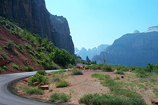
State Route 9 (SR-9) is a 57.075-mile-long (91.853 km) state highway in southern Utah, serving Zion National Park. It starts at the western terminus at exit 16 on Interstate 15 (I-15), passing through Zion National Park, and ending at the eastern junction with U.S. Route 89 (US-89). The entire length of the highway has been designated the Zion Park Scenic Byway. There is a fee to travel through Zion National Park, but the Zion-Mt. Carmel Highway is open to private vehicles year-round. A separate fee is required for vehicles 7'10" wide and/or 11'4" tall or larger. This fee pays for a park employee to stop traffic from the other side of the Zion - Mt. Carmel Tunnel to allow the larger vehicles to pass through. There is a smaller tunnel in Zion National Park that does not require an escort. Commercial vehicles are prohibited from using SR-9 and are directed to use SR-20 instead.
Pennsylvania Route 872 is a 39.8-mile-long (64.1 km) state highway located in Cameron and Potter Counties in Pennsylvania. The southern terminus is at PA 120 in Grove Township. The northern terminus is at U.S. Route 6 /PA 44 in Coudersport.

Richland Township is one of fifteen townships in Greene County, Indiana, USA. As of the 2010 census, its population was 5,019.
Architects of the National Park Service are the architects and landscape architects who were employed by the National Park Service (NPS) starting in 1918 to design buildings, structures, roads, trails and other features in the United States National Parks. Many of their works are listed on the National Register of Historic Places, and a number have also been designated as National Historic Landmarks.
Bourbon Township is one of ten townships in Boone County, Missouri, USA. As of the 2012, its population was 2,729. The township's major city is the railroad town of Sturgeon.
Cedar Township is the southernmost of ten townships in Boone County, Missouri, USA. As of the 2012, its population was 4,190. The township's major cities include the river town of Hartsburg and part of the prairie town Ashland.
Missouri Township is one of ten townships in Boone County, Missouri, USA. As of the 2012, its population was 63,334. The township is western half of the City of Columbia making it the most populous township in Boone County.
Perche Township is one of ten townships in Boone County, Missouri, USA. As of the 2012, its population was 4,037. The village of Harrisburg is the only incorporated settlement inside the township.
Three Creeks Township is one of ten townships in Boone County, Missouri, USA. The township's contains part of the city of Ashland and also a part of the village of Pierpont.
Cedar Creek is a stream in Boone and Callaway counties of the U.S. state of Missouri. It is a tributary of the Missouri River. The headwaters of Cedar Creek are in northeast Boone County about five miles east of Hallsville and one mile west of the Audrain-Boone county line. The stream flows south and about five miles south of its headwaters the stream becomes the boundary between Boone and Callaway counties. The stream crosses under Interstate 70 about eight miles east of Columbia and enters the Mark Twain National Forest. The stream flows south to southwest through the national forest and upon leaving the forest turns to the east and ceases to be the county line. The stream flows east for about one mile then turns south and flows under U. S. Route 63 and into the Missouri River four miles northwest of Cedar City and across the river from Jefferson City. The Katy Trail crosses Cedar Creek just north of its confluence with the Missouri.

Hinkson Creek is a stream in Boone County in the U.S. state of Missouri. Its middle section runs through the city of Columbia, Missouri It was named after Robert Hinkson, a pioneer citizen who lived along its banks. Several trails, conservation areas, and parks are along its path. it eventually empties into Perche Creek southwest of Columbia. The MKT Trail follows the creek in Boone County.
Rock Fork Lakes Conservation Area is a nature preserve and former strip mine in Boone County, Missouri. Located north of Columbia, Missouri adjacent to Finger Lakes State Park it is over 2000 acres of lakes, wetlands, forest, and prairie. Much of the land is severely degraded from strip mining by the Peabody Coal Company from 1963 to 1972. The land was acquired by the Missouri Department of Conservation in 1979. An unstaffed shooting range is open to the public and was renovated in 2014. The 50-acre Rocky Fork Lake has a boat ramp and is used for fishing. It is named after Rocky Fork Creek.

