
The Seacoast Region is the southeast area of the U.S. state of New Hampshire that is centered around the city of Portsmouth. It includes the eastern portion of Rockingham County and the southern portion of Strafford County. At its narrowest definition, the region stretches 13 miles (21 km) along the Atlantic Ocean from New Hampshire's border with Salisbury, Massachusetts, to the Piscataqua River and New Hampshire's border with Kittery, Maine. The shoreline alternates between rocky and rough headlands and areas with sandy beaches. Some of the beaches are bordered by jetties or groins, particularly in the towns of Rye and Hampton. Most definitions of the Seacoast Region includes some inland towns as well, including the Great Bay area cities of Dover and Rochester, the college town of Durham, and areas as far west as Epping. Some definitions also include nearby portions of York County, Maine that are culturally aligned with the Portsmouth area rather than the Portland, Maine metropolitan area.
Annisquam is a waterfront village in the city of Gloucester in Essex County on the North Shore of Massachusetts, United States. It is a few miles across Cape Ann from downtown Gloucester.

The Kennedy Compound consists of three houses on six acres of waterfront property on Cape Cod along Nantucket Sound in Hyannis Port, Massachusetts, in the United States. It was once the home of Joseph P. Kennedy, an American businessman, investor, politician, and U.S. ambassador to the United Kingdom; his wife, Rose; and their children, including U.S. President John F. Kennedy and U.S. Senators Robert F. Kennedy and Edward M. Kennedy. As an adult, the youngest son, Edward, lived in his parents' house, and it was his primary residence from 1982 until he died of brain cancer at the compound, in August 2009.
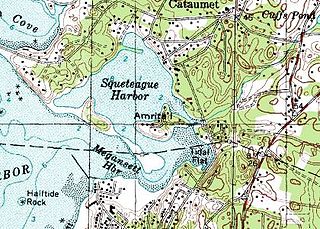
Amrita Island is a small inhabited island in Squeteague Harbor in the village of Cataumet in the town of Bourne, in Barnstable County, Massachusetts. Several residential homes are located on the island. Baxendale Road is the only road and it connects the island to the mainland from Megansett Road.

Bakers Island is a small, private residential island in Massachusetts Bay, in Salem, Massachusetts. It is located southeast of Great Misery Island & Little Misery Island, northeast of North Gooseberry Island and South Gooseberry Island, and far northeast of Children's Island. It is the outermost island on the main shipping channel into Salem Harbor. Bakers Island Light, located on the island's northern side, is used for navigation.
Bassetts Island is a Y-shaped island within Pocasset Harbor and Red Brook Harbor, in Bourne, Massachusetts, USA. 41-40’48” North x 070-38’13” West
Ontarioville is a small neighborhood within the village of Hanover Park, Illinois.

The Jones River is a 7.5-mile-long (12.1 km) river running through Kingston, Massachusetts. The river drains about 30 square miles (78 km2), has its source in Silver Lake and drains into Kingston Bay. Land surrounding the river is 52% forested, of which 22% has been developed for residential use. There is a USGS stream gauge along 16 square miles (41 km2) of the river and it has measured the flow at 0.7 cubic feet per second (0.020 m3/s) per square mile of drainage area.

Oakland Beach is a neighborhood and beach located in the South Central area of Warwick, Rhode Island, on Greenwich Bay, a tributary of Narragansett Bay. In the late 1800s, Oakland Beach was the site of Camp Wetmore, the site of six day annual training encampment of the Rhode Island Militia. Around 1895 the encampment was moved to a larger and better equipped facility at Quonset Point.

Plymouth Bay is a small, well-protected bay of the Atlantic Ocean on the western shore of larger Cape Cod Bay along the coastline of the Commonwealth of Massachusetts. Plymouth Bay retains historical significance for the landing at Plymouth Rock in 1620 by the Pilgrims aboard the Mayflower who proceeded to establish the first permanent Northern European settlement in North America at Plymouth Colony.
South Plymouth is the portion of Plymouth, Massachusetts, United States that covers much of the southern section of the town, beginning at the Pine Hills, a large, mostly undeveloped forested area south of Plymouth Beach, Chiltonville and South Pond. The remainder of the section is south and east of the northeastern entrance to Myles Standish State Forest, stretching to the Bourne and Wareham town lines.
West Plymouth is a village in Plymouth, Plymouth County, Massachusetts, United States. It is located beyond the Colony Place retail development and the Plymouth Industrial Park off U.S. Route 44 and north of Myles Standish State Forest. It stretches west to the Carver town line and north to the Kingston town line. The villages within this section include Micajah Heights, a community surrounding Micajah Pond, Billington Sea, a village along the southern shore of the pond, Darby, a village surrounding Darby Pond, and the portion of East Carver that extends into Plymouth.

Cedarville is the southeasternmost village in Plymouth, Massachusetts, United States. It is bounded to the north by Ellisville Road and Hedges Pond, to the south by the town of Bourne, to the west by Little Herring Pond and Great Herring Pond, and to the east by Cape Cod Bay.
Pine Hills is a sparsely populated hilly region located in Plymouth, Massachusetts, in the United States. It is a large, mostly undeveloped hilly and forested area lying south of Plymouth Beach and Chiltonville, north of Manomet, and east of Route 3, where the southern portion of the region can be accessed from Exit 3, and the northern portion can be accessed from Exit 4. The area rises from Plymouth Bay at Rocky Point, which is considered to be located in the foothills of the region, and runs southwest. Route 3A winds through the heart of the Pine Hills. The region consists of the Rocky Point neighborhood in the north and The Pinehills, a new residential and commercial development in the extreme southern part of the area.

Warren Cove is an exclusive oceanfront residential area Plymouth Bay in Plymouth, Massachusetts. Plymouth Beach and Rocky Point surround the southern edge of the cove. Stately homes along Warren Avenue and Rocky Hill Road have a commanding view of Plymouth Long Beach, Gurnet Light, Duxbury Bay, "Bug Light", Saquish, and Kingston Shores.
Rocky Point is a peninsula in Plymouth, Massachusetts. The peninsula runs along Warren Cove and Plymouth Bay. The tip of the peninsula marks the convergence of Plymouth Bay and the larger Cape Cod Bay. The land rising from Plymouth Bay is considered to be the foothills to the Pine Hills.
Wellingsley, also known as Wellingsly, Jabez Corner, and Hobs Hole, is a neighborhood in Plymouth, Massachusetts, United States. It is notable for being the oldest separate neighborhood in the town. Wellingsley is located one mile south of Plymouth Center and north of Chiltonville. The neighborhood is interchangeably called Hobs Hole and Jabez Corner by its residents. Hobs Hole is a small brook that runs along Nook Road and empties into Plymouth Harbor. The name Hob's Hole supposedly derives from "Hobbamock's Hole", referencing a natural harbour ascribed to a famous pniese Pokanoket living with the pilgrims. Jabez Corner, at the intersection of Sandwich Street and Warren Avenue, which Route 3A passes through, is a location containing several small stores.

Menauhant is a neighborhood at the southern end of Central Avenue in East Falmouth, Massachusetts, United States. The community, which lies between Bournes Pond on the west and Eel Pond on the east, is located across Vineyard Sound from Martha's Vineyard. The community has approximately 105 homes, the earliest of which date to the 1870s, a small chapel that serves the community during the summer months, and the public Menauhant Beach. The neighborhood is the home of the Menauhant Yacht Club, which owns two private beaches, tennis courts and several boats, and hosts a summer program for members.

The William J. Rotch Gothic Cottage is a historic cottage on 19 Irving Street in New Bedford, Massachusetts. The Gothic Revival cottage was built in 1845 to a design by noted New York City architect Alexander Jackson Davis. It was built for William J. Rotch, a member of one of New Bedford's leading whaling families. It is for these two associations that it was designated a National Historic Landmark in 2006. It is one a very few surviving Gothic cottage designs by Davis, exhibiting features not found in the others that do. The house was included in The Architecture of Country Houses, published in 1850, bringing it early fame and making it an iconic example of the style.
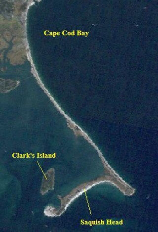
Saquish Beach, sometimes simply referred to as Saquish, is a beach and headland located at the end of the peninsula at the entrance to Plymouth Bay in Plymouth, Massachusetts. A small private settlement of summer cottages line the beach and headland, sometimes referred to as Saquish Neck and Saquish Head respectively. It is located east of Clark's Island and west of Gurnet Point. Its only access by land is from the Powder Point Bridge at Duxbury Beach, 5 miles to the north by foot or by 4-wheel drive beach buggies. As a private beach, access is restricted to property owners, residents, and their guests.

