
Josephine County is one of the 36 counties in the U.S. state of Oregon. As of the 2020 census, the population was 88,090. The county seat is Grants Pass. The county is probably named after a stream in the area called Josephine Creek, which in turn is probably named after Virginia Josephine Rollins Ort. Josephine County comprises the Grants Pass, OR Metropolitan Statistical Area, which is included in the Medford-Grants Pass, OR Combined Statistical Area.

Jackson County is one of the 36 counties in the U.S. state of Oregon. As of the 2020 census, the population was 223,259. The county seat is Medford. The county is named for Andrew Jackson, the seventh president of the United States.

Medford is a city in and the county seat of Jackson County, Oregon, in the United States. As of the 2020 United States Census on April 1, 2020, the city had a total population of 85,824 and a metropolitan area population of 223,259, making the Medford MSA the fourth largest metro area in Oregon. The city was named in 1883 by David Loring, civil engineer and right-of-way agent for the Oregon and California Railroad, after Medford, Massachusetts, which was near Loring's hometown of Concord, Massachusetts. Medford is near the middle ford of Bear Creek.

The Rogue River in southwestern Oregon in the United States flows about 215 miles (346 km) in a generally westward direction from the Cascade Range to the Pacific Ocean. Known for its salmon runs, whitewater rafting, and rugged scenery, it was one of the original eight rivers named in the Wild and Scenic Rivers Act of 1968. Beginning near Crater Lake, which occupies the caldera left by the explosive volcanic eruption and collapse of Mount Mazama, the river flows through the geologically young High Cascades and the older Western Cascades, another volcanic province. Further west, the river passes through multiple exotic terranes of the more ancient Klamath Mountains. In the Kalmiopsis Wilderness section of the Rogue basin are some of the world's best examples of rocks that form the Earth's mantle. Near the mouth of the river, the only dinosaur fragments ever discovered in Oregon were found in the Otter Point Formation, along the coast of Curry County.
TouVelle State Recreation Site is a state park, administered by Oregon Parks and Recreation Department, and located in Jackson County, Oregon, United States, 9 miles (14 km) north of Medford, where Table Rock Road crosses the Rogue River. This 51-acre (210,000 m2) park is used for fishing, birding, hiking, picnicking and swimming. There is also a boat ramp, which lies at the lower end of an easily navigated stretch of the Rogue. A daily user-fee or annual permit is required.

Prospect is an unincorporated community and census-designated place (CDP) in Jackson County, in the U.S. state of Oregon. It lies along Oregon Route 62 on the Rogue River, in the Rogue River – Siskiyou National Forest. As of the 2010 census it had a population of 455.

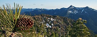
Umpqua National Forest, in southern Oregon's Cascade Range, covers an area of 983,129 acres (3,978.58 km2) in Douglas, Lane, and Jackson counties, and borders Crater Lake National Park. The four ranger districts for the forest are the Cottage Grove, Diamond Lake, North Umpqua, and Tiller ranger districts. The forest is managed by the United States Forest Service, headquartered in Roseburg.
The Rogue River–Siskiyou National Forest is a United States National Forest in the U.S. states of Oregon and California. The formerly separate Rogue River and Siskiyou National Forests were administratively combined in 2004. Now, the Rogue River–Siskiyou National Forest ranges from the crest of the Cascade Range west into the Siskiyou Mountains, covering almost 1.8 million acres (7,300 km2). Forest headquarters are located in Medford, Oregon.

Valley of the Rogue State Park is a state park in west central Jackson County, Oregon, near Grants Pass and Medford, and is administered by the Oregon Parks and Recreation Department. It lies along the banks of the Rogue River, adjacent to Interstate 5. The park offers a year-round, full-service campground, a nature trail, a day-use area, and river access for boating, fishing, and swimming.

Lost Creek Lake is a reservoir located on the Rogue River in Jackson County, Oregon, United States. The lake is impounded by William L. Jess Dam which was constructed by the U.S. Army Corps of Engineers in 1977 for flood control and fisheries enhancement. The lake and dam were the first completed elements of the multi-purpose Rogue River Basin Project, consisting of Lost Creek Lake, Applegate Lake and the Elk Creek project. The lake is located approximately 27 miles (43 km) northeast of Medford.
Rock Point is an unincorporated community in Jackson County, Oregon, United States. Rock Point lies just north of an I-5 and Oregon Route 99 interchange along the Rogue River between the cities of Rogue River and Gold Hill.

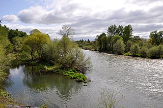
The Rogue River in the U.S. state of Oregon begins at Boundary Springs on the border between Klamath and Douglas counties near the northern edge of Crater Lake National Park. The Rogue River flows generally west for 215 miles (346 km) from the Cascade Range through the Rogue River – Siskiyou National Forest and the Klamath Mountains to the Pacific Ocean at Gold Beach. Communities along its course include Union Creek, Prospect, Trail, Shady Cove, Gold Hill, and Rogue River, all in Jackson County; Grants Pass, and Galice in Josephine County, and Agness, Wedderburn and Gold Beach in Curry County. Significant tributaries include the South Fork Rogue River, Elk Creek, Bear Creek, the Applegate River, and the Illinois River. Arising at 5,320 feet (1,622 m) above sea level, the river loses more than 1 mile (1.6 km) in elevation by the time it reaches the Pacific.

Elk Creek is an 18-mile (29 km) tributary of the Rogue River in the U.S. state of Oregon. Beginning at 4,931 feet (1,503 m) above sea level in the western foothills of the Cascade Range, it flows generally southwest through the Rogue River – Siskiyou National Forest and the U.S. Army Corps of Engineers Elk Creek Project lands to Rogue Elk Park in Jackson County. Here the creek enters the Rogue River 5.25 miles (8.45 km) downstream from Lost Creek Lake and 3.2 miles (5.1 km) river miles upstream of the small town of Trail. Elk Creek Dam, an incomplete flood-control structure that blocked fish migration for more than 20 years, was partly demolished in 2008 to restore endangered anadromous fish passage.

Shady Cove is a city in Jackson County, Oregon, United States. The population was 2,904 at the 2010 census.
McKee Bridge is an unincorporated community in Jackson County, Oregon, United States. It lies south of Ruch along Upper Applegate Road off Oregon Route 238. The Applegate River flows by the community, in the Rogue River – Siskiyou National Forest.

The Rogue Elk Hotel is a historic building in Trail, Oregon.

Union Creek is a 15-mile (24 km) long tributary of the Rogue River in the U.S. state of Oregon. Beginning west of Union Peak in the Cascade Range, it flows through the Rogue River – Siskiyou National Forest to meet the Rogue at Union Creek and the Union Creek Historic District.
Bitter Lick is an unincorporated community in Jackson County, Oregon, United States. It lies at the confluence of Bitter Lick Creek and Elk Creek, northwest of the ghost town of Persist. Bitter Lick is in the northern part of the county, north of Lost Creek Lake, a reservoir on the Rogue River.
Table Rock is an unincorporated community in Jackson County, Oregon, United States. It lies near the Rogue River along Table Rock Road between White City and Sams Valley. The topographic features known as Upper and Lower Table Rock are slightly west of the community. Between 1853 and 1856, the Table Rock Indian Reservation lay between Upper Table Rock and Evans Creek, a Rogue River tributary to the west.
Cascade Gorge is an unincorporated community in Jackson County, Oregon, United States. It lies along the Rogue River downstream of Prospect near the upper end of Lost Creek Lake. Oregon Route 62 passes through Cascade Gorge. The South Fork Rogue River enters the main stem slightly upstream of Cascade Gorge on the opposite bank.


