
Sumpter is a city in Baker County, Oregon, United States. The population was 204 at the 2010 census. Sumpter is named after Fort Sumter by its founders. The name was inspired by a rock as smooth and round as a cannonball, which reminded a local resident of the American Civil War and Fort Sumter.

Granite is a city in Grant County, in the U.S. state of Oregon. The city had a population of 38 in 2010, up from 24 in 2000. In 2010, it was the fourth-smallest incorporated city by population in Oregon. The smaller cities were Shaniko, Lonerock (21), and nearby Greenhorn (0).

Leesburg is an unincorporated community in Lemhi County, Idaho, United States. It lies at 45°13′26″N114°6′50″W, along Napias Creek in the Salmon National Forest, west of Salmon. Its altitude is 6,653 feet (2,028 m). The community possessed a post office as late as 1942, but it has since closed. Little remains of the original community. The entire site has been listed on the National Register of Historic Places since 1975.

Blue Tent is a historic 19th century gold mining community located about six miles northeast of Nevada City, California.

Red Dog was a California gold rush mining town located in the Gold Country in south-central Nevada County, California, United States, 6 mi (9.7 km) northeast of Chicago Park. Red Dog Hill, a mine and campsite, was founded by three men all under the age of 22, and was named by their youngest, a 15-year-old prospector. As mining operations grew, the campsite became a settlement, and then a town with a population of 2,000 residents, before it was eventually abandoned. Still considered important today, Red Dog Townsite is listed on the National Register of Historic Places. Red Dog has been noted for its unusual place name.
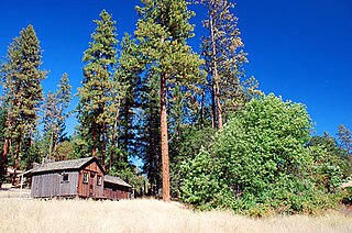
Buncom is an abandoned mining town at the confluence of the Little Applegate River and Sterling Creek in Jackson County, Oregon, United States. It is approximately 20 miles (32 km) southwest of Medford, at an elevation of 1,683 feet (513.0 m) above sea level. The site is promoted by the local historical society as a ghost town.

Golden is an abandoned mining town located at Coyote Creek in Josephine County, Oregon, United States.
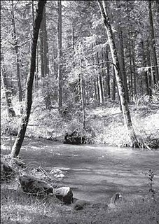
The Little Applegate River is a 21-mile-long (34 km) tributary of the Applegate River located in the U.S. state of Oregon. It is part of the Rogue River watershed, draining approximately 113 square miles (293 km2) of Jackson County. Rising in the Siskiyou Mountains, the river flows generally northwest to meet the Applegate about 3 miles (4.8 km) northwest of Buncom and 2 miles (3.2 km) south of Ruch.

Placer is an unincorporated community in Josephine County, Oregon, United States, on Grave Creek a few miles east of Interstate 5. Established during the local gold mining boom, it is considered a ghost town.
Tolo is an unincorporated community in Jackson County, Oregon, United States, located north of Interstate 5, between Central Point and Gold Hill, south of Sams Valley. Originally named Willow Springs, the town was envisioned to be one of the biggest cities of Southern Oregon. Tolo was platted in 1888, but was virtually abandoned by the year 1918. In 1986, the Jackson County Commission returned the plat to public ownership.

Wilkesboro is an unincorporated community in Washington County, Oregon, United States. It is located on Oregon Route 6, one mile east of Banks.
Lime is an unincorporated community and ghost town in Baker County, Oregon, United States, 5 miles (8 km) north of Huntington on U.S. Route 30/Interstate 84. It is near the confluence of Marble Creek and the Burnt River on the Union Pacific Railroad. The Oregon Trail passes through Lime.
Bourne is a ghost town in Baker County, Oregon, United States about 7 miles (11 km) north of Sumpter in the Blue Mountains. It lies on Cracker Creek and is within the Wallowa–Whitman National Forest. Platted in 1902, the former gold mining boomtown is considered a ghost town today.
Riverton is an unincorporated community in Coos County, Oregon, United States, on Oregon Route 42S, about 12 miles (19 km) up the Coquille River from Bandon. Route 42S is the former alignment of U.S. Route 101.
Galena is an unincorporated community in Grant County, Oregon, United States, about 20 miles (32 km) from Austin Junction in the Blue Mountains. It is on the Middle Fork John Day River in the Malheur national forest. The former gold mining camp is considered a ghost town.
Susanville is an unincorporated community in Grant County, Oregon, United States, in the Blue Mountains about two miles up Elk Creek from Galena. The place was started as a gold mining camp in 1862 or 1864 and is now considered a ghost town.
Nonpareil is an unincorporated historic community in Douglas County, Oregon, United States. It is about 8 miles (13 km) east of Sutherlin, near Calapooya Creek. The population of the area was about 202 in 2000. Nonpareil was the birthplace of novelist H. L. Davis.
Hamlet is an unincorporated community in Clatsop County, Oregon, United States. It is located approximately six miles southeast of Necanicum, in the Northern Oregon Coast Range near the confluence of the North Fork Nehalem River and the Little North Fork Nehalem River. It is surrounded by units of the Clatsop State Forest.
Holland is an unincorporated community in Josephine County, Oregon, United States. It is about eight miles southeast of Cave Junction, in the Illinois Valley south of Oregon Route 46.
Greenback is a ghost town and former mining town in Josephine County, Oregon.


