
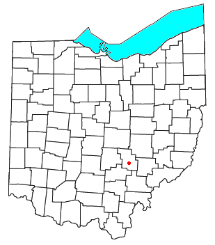
Royalton is an unincorporated community in northern Amanda Township, Fairfield County, Ohio, United States. [1]
Royalton is an unincorporated community in northern Amanda Township, Fairfield County, Ohio, United States. [1]
Royalton was laid out in 1810. [2] An early variant name was Tobytown. [3] A post office was established at Royalton in 1818, and remained in operation until 1909. [4]
The village lies at the intersection of Royalton and Amanda-Northern Roads. Located in the west of the county, it lies approximately 9 miles (14 km) west of central Lancaster (the county seat of Fairfield County) and 6 miles (9.7 km) north of the village of Amanda. The nearest body of running water is a small creek, which eventually empties into the Hocking River. [5]


Pickaway County is a county in the U.S. state of Ohio. As of the 2020 census, the population was 58,539. Its county seat is Circleville. Its name derives from the Pekowi band of Shawnee Indians, who inhabited the area.

Fairfield County is a county located in the U.S. state of Ohio. As of the 2020 census, the population was 158,921. Its county seat and largest city is Lancaster. Its name is a reference to the Fairfield area of the original Lancaster.

The Huron River is a 14.9-mile-long (24.0 km) waterway in the north central Ohio in the United States. The watershed drains large portions of Erie County and Huron County, the northeast corners of Seneca County and Crawford County, and northern portions of Richland County.

Fairfield Township is one of thirteen townships in Butler County, Ohio, United States. It is located in the south central portion of the county. The population was 22,645 at the 2020 census. Before annexations by the cities of Hamilton and Fairfield, it had an area of about 50 square miles (130 km2).

West Middletown is an unincorporated community in eastern Madison Township, Butler County, Ohio, United States. It is located on the west shore of the Great Miami River about one mile from Middletown. It had about 200 people in 1905 and was formerly a station on the Cincinnati, Hamilton, and Dayton Railroad. Founded as Madison City, it received the name Heno when it was awarded a post office in 1882. Since there was already another Madison City in Ohio, the postmaster general demanded a name change. According to legend, as old-timers were discussing the new name around the cracker barrel in the general store, a can of Heno tea caught their attention. So the town was named for the tea. But in 1907, the postmaster general decreed the village was within the shadow of Middletown, and only a few postal workers had ever heard of Heno, making it difficult to sort and forward mail to the place. The government ordered the village to accept the name of West Middletown. In 1963 the postmaster general in another decree closed the West Middletown post office, transferring its business to Middletown.
Lusk's Ferry Road was an early road in Illinois that provided an overland connection between the main settlement, Fort Kaskaskia, on the Mississippi River, and Lusk's Ferry, an important crossing point on the Ohio River. The overland route afforded an alternative to the river route, which required a difficult trip upstream on the Mississippi.

Monroe Township is one of the fourteen townships of Perry County, Ohio, United States. The 2020 census found 1,356 people in the township.

Amanda Township is one of the thirteen townships of Fairfield County, Ohio, United States. As of the 2020 census, the population was 2,722.
The Refugee Tract is an area of land in Ohio, United States granted to people from British Canada who left home prior to July 4, 1776, stayed in the US until November 25, 1783 continuously, and aided the revolutionary cause.

Clear Creek is a tributary of the Hocking River. It starts in western Fairfield County and flows southwest into northern Hocking County. In the upper half of the creek's watershed was glaciated and currently has a large amount of agricultural land use. The lower half is part of the unglaciated Allegheny Plateau and is much more forested. The creek's mouth is found at 39°35′49″N82°32′46″W
Bristol is an unincorporated community in southern Pike Township, Perry County, Ohio, United States. It lies along State Route 93 at its intersection with Marietta Road and Township Road 223. It is located 4 miles south of New Lexington, the county seat of Perry County.
Tedrow is an unincorporated community and census-designated place (CDP) in southwestern Dover Township, Fulton County, Ohio, United States. It lies at the intersection of the east-west County Road J with the north-south County Roads 17-2 and 17-3, 3 miles (5 km) north and 3.5 miles (5.6 km) west of the northern edge of the city of Wauseon, the county seat of Fulton County. The community lies less than one mile north of the Ohio Turnpike, although the nearest exit is several miles away.

The Seven Ranges was a land tract in eastern Ohio that was the first tract to be surveyed in what became the Public Land Survey System. The tract is 42 miles (68 km) across the northern edge, 91 miles (146 km) on the western edge, with the south and east sides along the Ohio River. It consists of all of Monroe, Harrison, Belmont and Jefferson, and portions of Carroll, Columbiana, Tuscarawas, Guernsey, Noble, and Washington County.

Allentown is an unincorporated community in Tazewell County, Illinois, United States. Allentown is in the Tremont Township, though it is closer to Mackinaw than to Tremont. Allentown is 2.5 miles (4.0 km) northwest of Mackinaw and 6 miles (9.7 km) northeast of Tremont.

The Little Hocking River is a small tributary of the Ohio River, 18.4 miles (29.6 km) long, in southeastern Ohio in the United States. Via the Ohio River, it is part of the watershed of the Mississippi River, draining an area of 102 square miles (260 km2) on the unglaciated portion of the Allegheny Plateau. The river flows for its entire length in southwestern Washington County; its tributaries also drain a small area of southeastern Athens County.

The Salt Reservations were a collection of land tracts surrounding salt springs in Ohio and some other states that were donated to the states by the federal government early in the 19th century.

Zane's Tracts were three parcels of land in the Northwest Territory of the United States, later Ohio, that the federal government granted to Ebenezer Zane late in the 18th century, as compensation for establishing a road with ferry service over several rivers.

Cedar Hill is an unincorporated community in northern Amanda Township, Fairfield County, Ohio, United States. It lies at the intersection of Lancaster-Circleville (SR-188), Cedar Hill, and Westfall Roads. Located in the west of the county, it lies west of Lancaster and south of the village of Lithopolis.

State Route 674 is a state highway located southeast of Columbus, Ohio. Most of the route straddles a county line; about 11 miles (18 km) of the southern part of route is on the Pickaway–Fairfield County line while the next 1.4 miles (2.3 km) is on the Fairfield-Franklin County line. The route's southern terminus is at US 22 just north of Stoutsville while the northern terminus is at an interchange with US 33 in the city of Canal Winchester.
Greencastle is an unincorporated community in Fairfield County, in the U.S. state of Ohio.
Municipalities and communities of Fairfield County, Ohio, United States | ||
|---|---|---|
| Cities |  | |
| Villages | ||
| Townships | ||
| CDPs | ||
| Unincorporated communities | ||
| Footnotes | ‡This populated place also has portions in an adjacent county or counties | |
39°43′39″N82°46′00″W / 39.72750°N 82.76667°W
| | This Fairfield County, Ohio state location article is a stub. You can help Wikipedia by expanding it. |