
In the Philippines, provinces are one of its primary political and administrative divisions. There are 82 provinces at present, which are further subdivided into component cities and municipalities. The local government units in the National Capital Region, as well as independent cities, are independent of any provincial government. Each province is governed by an elected legislature called the Sangguniang Panlalawigan and an elected governor.
Lanao del Norte, officially the Province of Lanao del Norte, is a province in the Philippines located in the Northern Mindanao region. Its capital is Tubod.

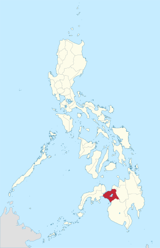
Lanao del Sur, officially the Province of Lanao del Sur, is a province in the Philippines located in the Bangsamoro Autonomous Region in Muslim Mindanao (BARMM). The capital is the city of Marawi, and it borders Lanao del Norte to the north, Bukidnon to the east, and Maguindanao del Norte and Cotabato to the south. To the southwest lies Illana Bay, an arm of the Moro Gulf.

The Autonomous Region in Muslim Mindanao was an autonomous region of the Philippines, located in the Mindanao island group of the Philippines, that consisted of five predominantly Muslim provinces: Basilan, Lanao del Sur, Maguindanao, Sulu, and Tawi-Tawi. It was the only region that had its own government. The region's de facto seat of government was Cotabato City, although this self-governing city was outside its jurisdiction.
Marawi, officially the Islamic City of Marawi, is a 4th class component city and capital of the province of Lanao del Sur, Philippines. According to the 2020 census, it has a population of 207,010 people.

Amai Manabilang, officially the Municipality of Amai Manabilang, is a 3rd class municipality in the province of Lanao del Sur, Philippines. According to the 2020 census, it has a population of 12,124 people.

Picong, officially the Municipality of Picong, is a 4th class municipality in the province of Lanao del Sur, Philippines. According to the 2020 census, it has a population of 18,907 people.
The legislative district of Agusan was the representation of the historical province of Agusan in the various national legislatures of the Philippines until 1969. Butuan also remained part of the province's representation even after becoming a chartered city in 1950.
The legislative districts of Lanao del Norte are the representations of the province of Lanao del Norte in the various national legislatures of the Philippines. The province is currently represented in the lower house of the Congress of the Philippines through its first and second congressional districts.
The legislative district of Lanao was the representation of the historical province of Lanao in the various national legislatures of the Philippines until 1969. Marawi and Iligan also remained part of the province's representation even after becoming chartered cities in 1940 and 1950, respectively.
The legislative districts of Lanao del Sur are the representations of the province of Lanao del Sur in the various national legislatures of the Philippines. The province is currently represented in the lower house of the Congress of the Philippines through its first and second congressional districts.
General elections were held for the first time on February 12, 1990, in the newly created Autonomous Region in Muslim Mindanao for the regional governor and vice governor.
Lake Dapao is a deep water lake located in the province of Lanao del Sur, southwest of Lake Lanao, in the island of Mindanao in the Philippines. It is one of the deepest lakes in the country, reaching a maximum depth of 120 metres (390 ft). It has an estimated surface area of 1,011 hectares (10.11 km2). The lake receives water from local run-off and several small rivers.
Lanao was a province of the Philippines from 1914 to 1959. Today, the province comprises Lanao del Norte and Lanao del Sur.
Sacred Mountain National Park is a national park in Marawi, Lanao del Sur in the Southern Philippines. The 94-hectare (230-acre) national park and protected area, located in Brgys. Guimba and Papandayan, was established on August 5, 1965, by Republic Act no. 4190. The main geographic feature of the park is Mount Mupo which has the height of 274.32-meter (900.0 ft). Activities in the park include birdwatching and trekking to the mountaintop where a pond is located.
Lake Butig National Park is a protected area of the Philippines located in the municipality of Butig, Lanao del Sur in Mindanao Island. The park spans an area of 68 hectares comprising Lake Butig and its surrounding forest. It was declared a national park in 1965 by virtue of Republic Act No. 4190.
Pantuwaraya Lake National Park is a protected area of the Philippines located in barangay Pantao Raya in the municipality of Saguiaran, Lanao del Sur. The park covers an area of 20 hectares comprising Lake Pantao Raya and surrounding area. It was declared a national park in 1965 by virtue of Republic Act No. 4190.
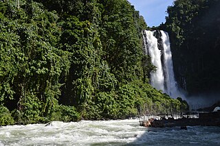
Salikata National Park is a protected area of the Philippines located in the municipality of Lumba-Bayabao, Lanao del Sur in Mindanao Island. Nestled in the thickly forested foothills of the Mount Ragang range, the park is one of the six national parks in the province of Lanao del Sur declared in 1965. The area is characterized by waterfalls, river gorge, rocky cliffs and dense canopy stretching the length of the Gata River valley from barangay Salaman to Mapantao near the provincial border with Cotabato.

An autonomous region of the Philippines is a first-level administrative division that has the authority to control a region's culture and economy. The Constitution of the Philippines allows for two autonomous regions: in the Cordilleras and in Muslim Mindanao. Currently, Bangsamoro, which largely consists of the Muslim-majority areas of Mindanao, is the only autonomous region in the country.
Lanao del Sur's at-large congressional district is an obsolete congressional district that encompassed the entire territory of Lanao del Sur in the Philippines. It was represented in the House of Representatives from 1961 to 1972 and in the Regular Batasang Pambansa from 1984 to 1986. The province of Lanao del Sur was created as a result of the division of Lanao in 1959 and elected its first representative provincewide at-large during the 1961 Philippine House of Representatives elections. Rasid Lucman was elected as this district's first representative. The district remained a single-member district until the dissolution of the lower house in 1972. It was later absorbed by the multi-member Region XII's at-large district for the national parliament in 1978. In 1984, provincial and city representations were restored and Lanao del Sur returned two members for the regular parliament. The district was abolished following the 1987 reapportionment that established two districts in the province under a new constitution.

