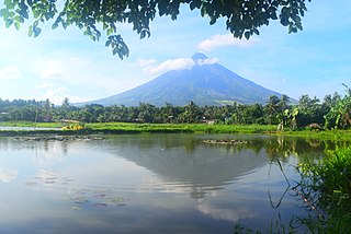
Bicol, also known as Bicol Region, is an administrative region of the Philippines, designated as Region V. Bicol comprises six provinces, four on the Bicol Peninsula mainland – Albay, Camarines Norte, Camarines Sur, and Sorsogon – and the offshore island provinces of Catanduanes and Masbate.

Camarines Sur is a province in the Philippines located in the Bicol Region in Luzon. Its capital is Pili and the province borders Camarines Norte and Quezon to the northwest, and Albay to the south. To the east lies the island province of Catanduanes across the Maqueda Channel.

Sequoia National Park is an American national park in the southern Sierra Nevada east of Visalia, California. The park was established on September 25, 1890 to protect 404,064 acres of forested mountainous terrain. Encompassing a vertical relief of nearly 13,000 feet (4,000 m), the park contains the highest point in the contiguous United States, Mount Whitney, at 14,505 feet (4,421 m) above sea level. The park is south of, and contiguous with, Kings Canyon National Park; both parks are administered by the National Park Service together as the Sequoia and Kings Canyon National Parks. UNESCO designated the areas as Sequoia-Kings Canyon Biosphere Reserve in 1976.
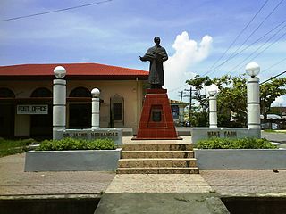
Libmanan, officially the Municipality of Libmanan, is a 1st class municipality in the province of Camarines Sur, Philippines. According to the 2015 census, it has a population of 108,716 people.
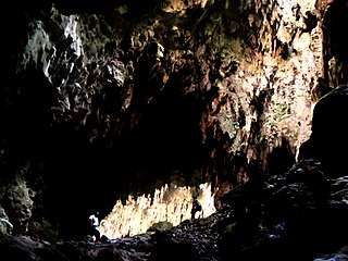
Callao Cave is one of 300 limestone caves located in the Barangays of Magdalo and Quibal in the municipality of Peñablanca, about 24 km (15 mi) northeast of Tuguegarao City, the capital of Cagayan province within the Peñablanca Protected Landscape and Seascape in the western foothills of the Northern Sierra Madre Mountains on Luzon island in the Philippines. The town Peñablanca's name refers to the predominance of white limestone rock formations in the area. First excavated in 1980 by Maharlika Cuevas, the seven-chamber show cave is the best known natural tourist attraction of the Cagayan province and in February 2020 has officially been recognized as an important cultural property of the Philippines.

The Puerto Princesa Subterranean River National Park is a protected area of the Philippines.
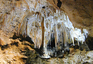
Carlsbad Caverns National Park is an American national park in the Guadalupe Mountains of southeastern New Mexico. The primary attraction of the park is the show cave, Carlsbad Cavern. Visitors to the cave can hike in on their own via the natural entrance or take an elevator from the visitor center.

Fort Rock Cave was the site of the earliest evidence of human habitation in the US state of Oregon before the excavation of Paisley Caves. Fort Rock Cave featured numerous well-preserved sagebrush sandals, ranging from 9,000 to 13,000 years old. The cave is located approximately 1.5 miles (2.4 km) west of Fort Rock near Fort Rock State Natural Area in Lake County. Fort Rock Cave was declared a National Historic Landmark in 1961, and added to the National Register of Historic Places in 1966.
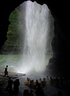
Pagsanjan Falls, also known as Cavinti Falls is one of the most famous waterfalls in the Philippines. Located in the province of Laguna, the falls is one of the major tourist attractions of the region. The three-drop waterfall is reached by a river trip on dugout canoe, known locally as Shooting the rapids, originating from the municipality of Pagsanjan. The falls can also be reached from the top by a short hike from Cavinti. The boat ride has been an attraction since the Spanish Colonial Era with the oldest written account in 1894. The town of Pagsanjan lies at the confluence of two rivers, the Balanac River and the Bumbungan River.
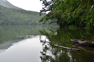
The Bulusan Volcano Natural Park is a 3,673-hectare (9,080-acre) protected area of rainforest surrounding Mount Bulusan in the Philippines. It was first designated as a National Park by Proclamation no. 811 on June 7, 1935. Under the National Integrated Protected Areas System (NIPAS) of 1992 managed by the Department of the Environment and Natural Resources, the park was reclassified as a Natural Park by Proc. 421 on November 27, 2000. The area features the volcano itself, Bulusan Lake, the two other mountains known as the 'Sharp Peak' and 'Hormahan' and Lake Aguingay. The park is in the south central part of Sorsogon Province, southern Luzon, Bicol Region, Philippines, bounded by five municipalities: Bulusan, Barcelona, Irosin, Juban and Casiguran.

Biak-na-Bato National Park is a protected area of the Philippines located almost entirely within Barangay Biak-na-Bato in San Miguel, Bulacan from where it derives its name. The park also extends to the nearby municipalities of San Ildefonso and Doña Remedios Trinidad covering a total area of 2,117 hectares. It was declared a national park in 1937 by President Manuel Luis Quezon by virtue of its association with the history and site of the Biak-na-Bato Republic. The park consists of a cave network and a system of rivers and trails of both historical and ecological importance. Situated only 80 kilometers northeast from Manila, it is fast becoming a popular weekend eco-adventure destination for the city dwellers.

Guadalupe Mabugnao Mainit Hot Spring National Park is a protected area of the Philippines located in Barangay Guadalupe in Carcar, Cebu, some 50 kilometers from the provincial capital Cebu City. The park covers an area of 57.50 hectares occupying an important watershed forest reserve in the central Mantalongon mountain range. It was declared a national park in 1972 by virtue of Republic Act No. 6429.

Fuyot Springs National Park is a protected area of the Philippines located in the mountain slopes of Barangay Santa Victoria in Ilagan City, Isabela, 405 kilometers northeast from Manila. The park, which also contains the Ilagan Sanctuary, is 819 hectares in area and extends to the nearby municipality of Tumauini. It was established in 1938 through Proclamation No. 327.

The Bulabog Putian National Park is a protected wildlife and natural park located in the towns of Dingle and San Enrique in the province of Iloilo on the island of Panay in the Western Visayas region. The park covers an area of 854.33 hectares along a 40 kilometers (25 mi) trail in this rainforest. It was established in 1961 through Proclamation No. 760 signed by President Carlos P. Garcia. The park is known for its unique geological formation and is the only limestone mountain formation in Iloilo. It is also known as the location of the Cry of Lincud which started the Philippine Revolution in Iloilo in 1898.

The Peñablanca Protected Landscape and Seascape is a protected area and national park in Peñablanca, Cagayan. It is on the border with Isabela province, contiguous with the Northern Sierra Madre Natural Park. The protected area, best known as the location of Callao Cave, covers the largest block of forest under conservation in the province. It covers 118,781.582 hectares of the northern Sierra Madre mountain range and its adjacent Pacific coast.

The Mainit Hot Springs Protected Landscape is a protected landscape area located in the province of Davao de Oro on the island of Mindanao in the Philippines. It preserves the sulfuric hot springs and surrounding forest in Nabunturan municipality which also contains the headwaters of the Manat River, a source of water supply for surrounding villages. First declared a national park in 1957 by virtue of Proclamation No. 466 by President Carlos P. Garcia, it had an initial area of 1,381 hectares. Under the National Integrated Protected Areas System, it was reclassified as a protected landscape through Proclamation No. 320 issued in 2000 by President Joseph Estrada. The hot springs are a popular ecotourist attraction in Davao de Oro. Its name "Mainit" is a Filipino word which means hot.
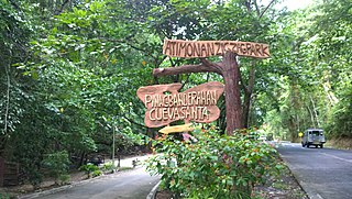
The Quezon Protected Landscape is a protected area in the Republic of the Philippines, spanning the municipalities of Pagbilao, Padre Burgos and Atimonan in Quezon province. The park is situated north of the narrowest section of Luzon in Quezon province, located about 164 km (102 mi) southeast of Metro Manila.


