A ZIP Code is a system of postal codes used by the United States Postal Service (USPS). Introduced on July 1, 1963, the basic format consisted of five digits. In 1983, an extended ZIP+4 code was introduced; it included the five digits of the ZIP Code, followed by a hyphen and four digits that designated a more specific location.

Columbia is a U.S. city in and the county seat of Marion County, Mississippi, which was formed six years before Mississippi was admitted to statehood. Columbia was named for Columbia, South Carolina, from which many of the early settlers had migrated. The population was 6,582 as of the 2010 census, and 5,864 in 2020.

Leland is a city in Washington County, Mississippi, United States. It is located within the Mississippi Delta, on the banks of Deer Creek. The population was 4,481 at the 2010 census. It was once a railway town and had long been a center of cotton culture, which is still an important commodity crop in the rural area. It was once considered the second-largest city in Washington County in 1920 due to its rapid growth of residents, businesses, and schools.

Deal is a borough situated on the Jersey Shore within Monmouth County, in the U.S. state of New Jersey. The community was settled by Europeans in the mid-1660s and named after an English carpenter from Deal, Kent. As of the 2020 United States census, the borough's population was 900, an increase of 150 (+20.0%) from the 2010 census count of 750, which in turn had reflected a decline of 320 (−29.9%) from the 1,070 counted in the 2000 census.

Belle Mead is an unincorporated community and census-designated place (CDP) located within Montgomery Township, in Somerset County, in the U.S. state of New Jersey. As of the 2020 United States census, the CDP's population was 5,569, reflecting an expansion of the CDP from 0.74 square miles (1.9 km2) in 2010 to 4.03 square miles (10.4 km2) in 2020.
Steens, also known as Jamisons Mill, is an unincorporated community in Lowndes County, Mississippi. Steens is located northeast of Columbus. The ZIP Code for Steens is 39766.

Walls is a town located in northern DeSoto County, Mississippi, United States, near the Mississippi River, part of the larger region known as "The Delta", and known for its rich, dark soil. As it is in the upper northwest corner of Mississippi, it is in the Memphis, Tennessee metropolitan area. Its ZIP code is 38680. As of the 2010 census it had a population of 1,162, with an estimated population of 1,463 in 2018.

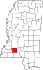
Valley Park is a census-designated place and unincorporated community in Issaquena County, Mississippi, United States. Its elevation is 95 feet. Although unincorporated, it has a post office, with the ZIP code of 39177.
Evans is an unincorporated community in western Jackson County, West Virginia, United States. It lies along West Virginia Route 87 west of the city of Ripley, the county seat of Jackson County. Its elevation is 594 feet (181 m). Although Evans is unincorporated, it has a post office, with the ZIP code of 25241. Evans is home to 20 businesses that employ 70 individuals.
Montpelier is an unincorporated community and census-designated place (CDP) in Muscatine County, Iowa, United States. As of the 2020 census, the population was 186. The community is part of the Muscatine Micropolitan Statistical Area.

Wever is an unincorporated community in northeastern Lee County, in the southeastern corner of Iowa, United States. As of the 2020 census, its population was 101.
Morgantown is an unincorporated community located on Mississippi Highway 587 in northwest Marion County, Mississippi, United States.
Sharon is an unincorporated community located on Mississippi Highway 43 in Madison County, Mississippi, United States. Sharon is approximately 12 miles (19 km) southwest of Camden and 7 miles (11 km) northeast of Canton. Sharon is located within the Jackson Metropolitan Statistical Area.
Victoria is a census-designated place and unincorporated community in Marshall County, Mississippi, United States. Its ZIP code is 38679.
McQuady is an unincorporated community in Breckinridge County, Kentucky, United States. McQuady is located at the junction of Kentucky Route 105 and Kentucky Route 261, 5.9 miles (9.5 km) south-southwest of Hardinsburg. McQuady has a post office with ZIP code 40153.
Rose Hill is an unincorporated community in Jasper County, Mississippi, United States. Its ZIP code is 39356.
Pattison, also known as Martin, is a census-designated place and unincorporated community in Claiborne County, Mississippi, United States. Its ZIP code is 39144.
Harperville is a census-designated place and unincorporated community in rural Scott County, Mississippi, United States. Harperville is located on Mississippi Highway 35, 9 miles (14 km) north of Forest. Harperville has a post office with ZIP code 39080.
Bethlehem is a census-designated place and unincorporated community in Marshall County, Mississippi, United States. Its ZIP code is 38659.
O.C. McDavid was an American newspaper editor, painter and sculptor. He was the managing editor of the Jackson Daily News from 1969 to 1977. He is the namesake of the annual O.C. McDavid Journalism Conference of the Mississippi Press Association, and his artwork can be seen on the campuses of Mississippi College and Delta State University.