A levee, dike, dyke, embankment, floodbank, or stop bank is a structure that is usually earthen and that often runs parallel to the course of a river in its floodplain or along low-lying coastlines.

A flood is an overflow of water that submerges land that is usually dry. In the sense of "flowing water", the word may also be applied to the inflow of the tide. Floods are an area of study of the discipline hydrology and are of significant concern in agriculture, civil engineering and public health. Human changes to the environment often increase the intensity and frequency of flooding, for example land use changes such as deforestation and removal of wetlands, changes in waterway course or flood controls such as with levees, and larger environmental issues such as climate change and sea level rise. In particular climate change's increased rainfall and extreme weather events increases the severity of other causes for flooding, resulting in more intense floods and increased flood risk.

The United States Army Corps of Engineers (USACE) is a direct reporting unit and engineer formation of the United States Army that has three primary mission areas: Engineer Regiment, military construction, and civil works. The day-to-day activities of the three mission areas are administered by a lieutenant general known as the commanding general/chief of engineers. The chief of engineers commands the Engineer Regiment, comprising combat engineer, rescue, construction, dive, and other specialty units, and answers directly to the Chief of Staff of the Army. Combat engineers, sometimes called sappers, form an integral part of the Army's combined arms team and are found in all Army service components: Regular Army, National Guard, and Army Reserve. Their duties are to breach obstacles; construct fighting positions, fixed/floating bridges, and obstacles and defensive positions; place and detonate explosives; conduct route clearance operations; emplace and detect landmines; and fight as provisional infantry when required. For the military construction mission, the commanding general is directed and supervised by the Assistant Secretary of the Army for installations, environment, and energy, whom the President appoints and the Senate confirms. Military construction relates to construction on military bases and worldwide installations.

The American Society of Civil Engineers (ASCE) is a tax-exempt professional body founded in 1852 to represent members of the civil engineering profession worldwide. Headquartered in Reston, Virginia, it is the oldest national engineering society in the United States. Its constitution was based on the older Boston Society of Civil Engineers from 1848.
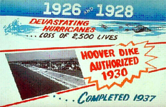
The Herbert Hoover Dike is a dike around the waters of Lake Okeechobee in Florida.

The London Avenue Canal is a drainage canal in New Orleans, Louisiana, used for pumping rain water into Lake Pontchartrain. The canal runs through the 7th Ward of New Orleans from the Gentilly area to the Lakefront. It is one of the three main drainage canals responsible for draining rainwater from the main basin of New Orleans. The London Avenue Canal's flood walls built atop earthen levees breached on both sides during Hurricane Katrina in 2005.
On Monday, August 29, 2005, there were over 50 failures of the levees and flood walls protecting New Orleans, Louisiana, and its suburbs following passage of Hurricane Katrina. The failures caused flooding in 80% of New Orleans and all of St. Bernard Parish. In New Orleans alone, 134,000 housing units — 70% of all occupied units — suffered damage from Hurricane Katrina and the subsequent flooding.

The Bonnet Carré Spillway is a flood control operation in the Lower Mississippi Valley. Located in St. Charles Parish, Louisiana, about 12 miles (19 km) west of New Orleans, it allows floodwaters from the Mississippi River to flow into Lake Pontchartrain and thence into the Gulf of Mexico. The spillway was constructed between 1929 and 1931, following the Great Mississippi Flood of 1927, and has been designated as a National Historic Civil Engineering Landmark by the American Society of Civil Engineers.

An hydrological transport model is a mathematical model used to simulate the flow of rivers, streams, groundwater movement or drainage front displacement, and calculate water quality parameters. These models generally came into use in the 1960s and 1970s when demand for numerical forecasting of water quality and drainage was driven by environmental legislation, and at a similar time widespread access to significant computer power became available. Much of the original model development took place in the United States and United Kingdom, but today these models are refined and used worldwide.
HEC-RAS is simulation software used in computational fluid dynamics – specifically, to model the hydraulics of water flow through natural rivers and other channels. Prior to the 2016 update to Version 5.0, the program was one-dimensional, meaning that there is no direct modeling of the hydraulic effect of cross section shape changes, bends, and other two- and three-dimensional aspects of flow. The release of Version 5.0 introduced two-dimensional modeling of flow as well as sediment transfer modeling capabilities. The program was developed by the United States Army Corps of Engineers in order to manage the rivers, harbors, and other public works under their jurisdiction; it has found wide acceptance by many others since its public release in 1995.
Internal erosion is the formation of voids within a soil caused by the removal of material by seepage. It is the second most common cause of failure in levees and one of the leading causes of failures in earth dams, responsible for about half of embankment dam failures.

GMS is water modeling application for building and simulating groundwater models from Aquaveo. It features 2D and 3D geostatistics, stratigraphic modeling and a unique conceptual model approach. Currently supported models include MODFLOW, MODPATH, MT3DMS, RT3D, FEMWATER, SEEP2D, and UTEXAS.

UTEXAS is a slope stability analysis program written by Stephen G. Wright of the University of Texas at Austin. The program is used in the field of civil engineering to analyze levees, earth dams, natural slopes, and anywhere there is concern for mass wasting. UTEXAS finds the factor of safety for the slope and the critical failure surface. Recently the software was used to help determine the reasons behind the failure of I-walls during Hurricane Katrina.
GSSHA is a two-dimensional, physically based watershed model developed by the Engineer Research and Development Center of the United States Army Corps of Engineers. It simulates surface water and groundwater hydrology, erosion and sediment transport. The GSSHA model is used for hydraulic engineering and research, and is on the Federal Emergency Management Agency (FEMA) list of hydrologic models accepted for use in the national flood insurance program for flood hydrograph estimation. Input is best prepared by the Watershed Modeling System interface, which effectively links the model with geographic information systems (GIS).
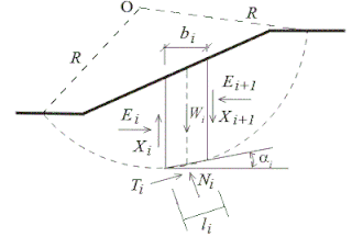
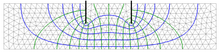
Slope stability analysis is a static or dynamic, analytical or empirical method to evaluate the stability of slopes of soil- and rock-fill dams, embankments, excavated slopes, and natural slopes in soil and rock. It is performed to assess the safe design of a human-made or natural slopes and the equilibrium conditions. Slope stability is the resistance of inclined surface to failure by sliding or collapsing. The main objectives of slope stability analysis are finding endangered areas, investigation of potential failure mechanisms, determination of the slope sensitivity to different triggering mechanisms, designing of optimal slopes with regard to safety, reliability and economics, designing possible remedial measures, e.g. barriers and stabilization.
SVSLOPE is a slope stability analysis program developed by SoilVision Systems Ltd.. The software is designed to analyze slopes using both the classic "method of slices" as well as newer stress-based methods. The program is used in the field of civil engineering to analyze levees, earth dams, natural slopes, tailings dams, heap leach piles, waste rock piles, and anywhere there is concern for mass wasting. SVSLOPE finds the factor of safety or the probability of failure for the slope. The software makes use of advanced searching methods to determine the critical failure surface.
SVFLUX is a finite element seepage analysis program developed by SoilVision Systems Ltd.. The software is designed to analyze both saturated and unsaturated flow through the ground through the solving of Richard's equation. The program is used in the fields of civil engineering and hydrology in order to analyze seepage and groundwater regional flow. The software is used for the calculation of flow rates, pore-water pressures, and pumping rates associated with regional groundwater flow. The software can be coupled with CHEMFLUX in order to calculate diffusion, advection, and decay rates or with SVHEAT in order to calculate thermal gradients and freeze/thaw fronts.
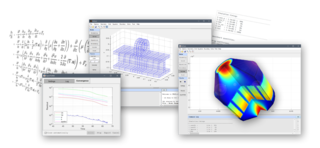
FEMtools is a multi-functional, cross-platform and solver-independent family of CAE software programs providing analysis and scripting solutions for many different types of engineering simulation applications. The program is developed, supported and licensed by Dynamic Design Solutions ("DDS") NV, located in Leuven, Belgium.
Aquaveo is a modeling software company based in Provo, Utah that develops software used to model and simulate groundwater, watershed, and surface water resources. Its main software products include SMS, GMS, WMS, and Arc Hydro Groundwater.
FEATool Multiphysics is a physics, finite element analysis (FEA), and partial differential equation (PDE) simulation toolbox. FEATool Multiphysics features the ability to model fully coupled heat transfer, fluid dynamics, chemical engineering, structural mechanics, fluid-structure interaction (FSI), electromagnetics, as well as user-defined and custom PDE problems in 1D, 2D (axisymmetry), or 3D, all within a graphical user interface (GUI) or optionally as script files. FEATool has been employed and used in academic research, teaching, and industrial engineering simulation contexts.