
The Nahuas are a group of the indigenous people of Mexico, El Salvador, Guatemala, Honduras, and Nicaragua. They comprise the largest indigenous group in Mexico and second largest in El Salvador. The Mexica (Aztecs) were of Nahua ethnicity, and the Toltecs are often thought to have been as well, though in the pre-Columbian period Nahuas were subdivided into many groups that did not necessarily share a common identity.

La Paz is a municipality in the State of Mexico, Mexico, with its municipal seat in the town of Los Reyes Acaquilpan. It is located on the dividing line between Mexico State and the eastern edge of the Federal District and is part of the Greater Mexico City area. The area was part of a region called "Atlicpac" which in Náhuatl means 'above or at the edge of water.' The current city's/municipality's glyph symbolizes water.
The civil unrest in San Salvador Atenco of 2006 began on Wednesday, May 3, when police prevented a group of 60 flower vendors from selling at the Texcoco local market in the State of México, about 30 km (19 mi) from Mexico City. State police used violence and arrest against resisters. The flower vendors appealed to the residents of San Salvador Atenco, a small neighboring community about 25 km (16 mi) northeast of Mexico City, famous for creating their resistance organization against the development of an airport on their land in 2002.
Chalco de Díaz Covarrubias is a city that is municipal seat of the surrounding municipality of Chalco. It lies in the eastern part of the State of Mexico just east of the Federal District of Mexico and is considered part of the Mexico City metropolitan area.

Ixtapaluca is a city and a municipality in the eastern part of the State of Mexico in Mexico. It lies between the Federal District and the western border of the state of Puebla. The name Ixtapaluca means "Where the salt gets wet".

Ciudad Nicolás Romero is the largest city and municipal seat of the municipality of Nicolás Romero in State of Mexico, Mexico. It is located 58 km from the city of Toluca, the state capital and lies in the north-central part of the state, just northwest of the Federal District. The seat/municipality's current name is to honor Nicolás Romero, who fought for Benito Juárez during the Reform War and the French intervention in Mexico. He was executed there by the French. The town adopted this name in 1898. The area was settled by the Otomi and named Azcapotzaltongo by the Aztecs after conquering it. During colonial times, it was known as San Pedro Azcapotzaltongo. It was then called Monte Bajo from 1821 to 1898, when the current name was adopted. Both the municipality and city are commonly referred to as Nicolás Romero.
Chiconcuac de Juárez, typically referred to simply as Chiconcuac, is a town and municipio (municipality) in the state of Mexico, approximately 10 kilometers north of Texcoco de Mora. The name Chiconcuac derives from the Aztec word Chicome Coatl, “Seven snakes”, which was a date on the Aztec calendar.

Acolman de Nezahualcóyotl is a town and municipality located in the northern part of State of Mexico, part of the Greater Mexico City area, just north of the city proper. According to myth, the first man was placed here after being taken out of Lake Texcoco. In the community of Tepexpan, the fossilized bones more than 12,000 years old of a man were found in the 20th century. The settlement was founded in the eighth century and was an important commerce center at the time of the Spanish conquest of the Aztec Empire.

Texcoco de Mora is a city located in the State of Mexico, 25 km northeast of Mexico City. Texcoco de Mora is the municipal seat of the municipality of Texcoco. In the pre-Hispanic era, this was a major Aztec city on the shores of Lake Texcoco. After the Conquest, the city was initially the second most important after Mexico City, but its importance faded over time, becoming more rural in character. Over the colonial and post-independence periods, most of Lake Texcoco was drained and the city is no longer on the shore and much of the municipality is on lakebed. Numerous Aztec archeological finds have been discovered here, including the 125 tonne stone statue of Tlaloc, which was found near San Miguel Coatlinchán and now resides at the Museum of Anthropology in Mexico City.
Chimalhuacán is a city and municipality located in the eastern part of State of Mexico, Mexico. It lies just outside the northeast border of Mexico City and is part of the Greater Mexico City urban area.

San Mateo Atenco is one of 125 municipalities in the State of México in Mexico. The municipal seat is the town of San Mateo Atenco. It lies west of the Federal District near the municipality of Metepec, in the central part of the state of México, and is part of the Toluca urban area bordering the city to the east. The name Atenco is derived from the Nahuatl language. It means “In the water’s edge”, from atl(water), tentli (edge) and co (in).
Jiquipilco Municipality is one of the municipalities of the State of Mexico in Mexico. It is north of the Toluca Valley, part of the region consisting of the southern and western slopes of Cerro La Catedral, which has a concentration of speakers of the Otomi language. It is about 40 km from Toluca, the state capital. The name is a corruption of Nahuatl “Xiquipilli”, meaning “the place of saddlebags”. Jiquipilco is situated on the transversal volcanic axis that crosses Mexico in an area surrounded by lakes and volcanoes. This portion is called "Anahuac”.
Texcaltitlán is a town and a municipality of the State of Mexico in Mexico. It is located 65 km from Toluca on the high plains south of the Nevado de Toluca volcano. The name Texcaltitlán comes from the Nahuatl: texcalli = “rock”; titla= "among", with the complete meaning as “among rocks”.
Tepetlaoxtoc de Hidalgo is a town and the seat of the municipality of Tepetlaoxtoc, which contains the archeological site of Tepetlaoxtoc, in the State of Mexico in Mexico. The name Tepetlaoxtoc comes from Náhuatl and means in limestone caves, and is used interchangeably to refer to the town, the municipality and the archeological ruins. 'de Hidalgo' was added to the town's name to honor Miguel Hidalgo who began the Mexican War of Independence. It is located about 100 km northeast of Mexico City.

Tlatelolco was a pre-Columbian altepetl, or city-state, in the Valley of Mexico. Its inhabitants, known as the Tlatelolca, were part of the Mexica, a Nahuatl-speaking people who arrived in what is now central Mexico in the 13th century. The Mexica settled on an island in Lake Texcoco and founded the altepetl of Mexico-Tenochtitlan on the southern portion of the island. In 1337, a group of dissident Mexica broke away from the Tenochca leadership in Tenochtitlan and founded Mexico-Tlatelolco on the northern portion of the island. Tenochtitlan was closely tied with its sister city, which was largely dependent on the market of Tlatelolco, the most important site of commerce in the area.
Chimalhuacán is an archeological site located in the city and municipality of Chimalhuacán Atenco in the eastern part of Mexico State, Mexico. It lies just outside the northeast border of the Federal District. The name derives from the Nahuatl words “chimalli” (shield), hua and can (place), this would mean "Place of Shields".The ancient name of the city by its founders was “Chimalhuacantoyac”.The word Atenco, is also Nahuatl; A, “water”; tentli, “lip” and co, “place”, hence would mean “at the water side”.
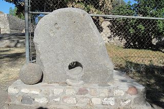
Huexotla or Huexotla is an archaeological site located 5 kilometers south of Texcoco, at the town of San Luis Huexotla, close to Chapingo, in the Mexico State.

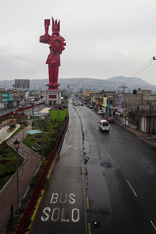
Ecatepec, officially Ecatepec de Morelos, is a municipality in the central Mexican state of Mexico, and is situated in the north part of the greater Mexico City urban area. The municipal seat is San Cristóbal Ecatepec.

Mexico City Texcoco Airport was a planned airport in Mexico City that was meant to become Mexico's New International Airport. The project was announced in September 2014 but was canceled in late 2018 after a referendum was held stating that the new airport should be built at a different location. Felipe Ángeles International Airport opened in March 2022.

Lake Zumpango is an endorheic basin located in the Valley of Mexico in the municipality of Zumpango and adjacent to the municipality of Teoloyucan. Tzompanco was formerlly the northernest of five interconnected lakes, covering about 1,500 square kilometers (580 sq mi). The Valley of Mexico was a centre for several pre-Columbian civilizations including Teotihuacan, the Toltec, and the Aztec Empire. After the conquest of the Aztec Empire, the Spaniards began to drain the lakes' waters to control flooding. Over the centuries Lake Zumpango lost it its inflows and outflows and became polluted by sewage and garbage dumps. However, in recent years, the lagoon is becoming cleaner again.
