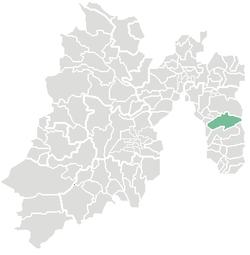
Ixtapaluca

Last updated
Ixtapaluca
Town & Municipality
Gemeente Ixtapaluca.PNG
Location of Ixtapaluca in the State of Mexico
Coordinates: 19°19′07″N98°52′56″W / 19.31861°N 98.88222°W / 19.31861; -98.88222
Country Flag of Mexico.svg  Mexico
State Flag of the State of Mexico.svg State of Mexico
Region Ixtapaluca
Metro area Greater Mexico City
Municipal StatusDecember 5, 1820 [1]
Municipal SeatIxtapaluca
Government
  Type Ayuntamiento
  Municipal PresidentCarlos Enriquez Santos
Area
  Municipality327.40 km2 (126.41 sq mi)
  Land327.40 km2 (126.41 sq mi)
  Water0.00 km2 (0.00 sq mi)
Elevation
(seat)
2,250 m (7,380 ft)
Population
 (2015) 
  Municipality495,563
  Seat
290,076
Demonym Ixtapaluquense
Time zone UTC-6 (CST)
  Summer (DST) UTC-5 (CDT)
Postal code (of seat)
56530
Area code 55
Website Official website (in Spanish)

Ixtapaluca is a city and a municipality in the eastern part of the State of Mexico in Mexico. It lies between Mexico City and the western border of the state of Puebla. The name Ixtapaluca means "Where the salt gets wet". [2]

Contents

As of 2006, Ixta included part of the world's largest mega-slum, along with Chalco and Neza. [3]

The city

At the census of 2005 the city had a population of 290,076. [4]

The parish of Ixtapaluca was founded in 1531 and had great prominence in the area. The municipal palace was built in 1973. [2]

The municipality

As municipal seat, the town of Ixtpaluca has governing jurisdiction over the following communities: Acozac, Ampliación San Francisco, Cabaña de los Medina, Camino a Mina Milagro (El Potrero), Camino Mina Rosita, Cerro de la Abundancia, Coatepec, Colonia Julio Chávez López (UPREZ), Colonia Tetitla, Ejido el Capulín, Ejido San Francisco (Las Joyas), Ejidos de Xalpa (Camino de los Alcanfores), El Campamento (Las Cocinas) El Carmen, El Corazón, El Cuarenta, El Jaral (El Capulín), El Patronato del Maguey (Santa Rosa), El Pozo del Venado, El Treinta y Nueve (Dos Jagüeyes), El Treinta y Siete (Kilómetro Diecinueve), General Manuel Ávila Camacho, Huertas de Canutillo, Jorge Jiménez Cantú, La Cañada, La Cañada, La Espinita (Parque Industrial la Espinita), La Granja, La Guadalupana, La Mesa, Linderos de Ixtapaluca (El Tablón), Llano Grande (Rancho Viejo), Loma del Rayo (Chocolines Segunda Sección), Lomas de Coatepec, Los Cedros, Los Hornos, Los Lavaderos, Los Vergeles, Piedra Grande (Las Cabañas), Pueblo Nuevo (San Isidro Labrador), Puente del Tablón, Puente el Mezquite, Rancho el Guarda, Rancho Francisco Santillán (Atzizintla Tres), Rancho la Pastoría, Rancho la Peña, Rancho Loma Ancha, Rancho los Gavilanes, Rancho San Isidro, Rancho Venta Nueva, Rancho Verde, Río Frío de Juárez, Ricardo Calva, San Buenaventura, San Francisco Acuautla, San Jerónimo Cuatro Vientos, Santa Ana, Santa Bárbara, Tierras Comunales (Cerro de Ayotla), Villas de Escalerillas (Bellavista), and Zoquiapan.

The municipality had a population of 429,033 in 2005. The area of the municipality is 315.10 km² (121.66 sq mi). [4] The municipality is part of the Mexico City metropolitan area. It is an important suburb because many people that work in Mexico City live in Ixtapaluca, and it has developed recent commercial interest due to this. The first "fraccionamiento" or subdivision called San José de la Palma, Municipio de Ixtapaluca, was built in 1989. The municipality is bordered by Chalco, Valle de Chalco Solidaridad, Chicoloapan, La Paz, Texcoco, Tlalmanalco, and the state of Puebla. [2]

The area was first settled in 1286 by the Mexicas. After the Spanish conquest, in 1543 Ixtapaluca was given to the control of Juan de Cuellar, who continued the indigenous practice of demanding tribute every 80 days from the people. [2]

Related Research Articles

Xico is a city in the State of Mexico, Mexico. It serves as the municipal seat of Valle de Chalco municipality, with which it is, for all practical purposes, coterminous. The municipality lies adjacent to the east side of the Federal District and is part of the Mexico City metropolitan area. The city and municipality lie on the old lakebed of Lake Chalco, which was drained like much of the Basin of Mexico. The city name comes from the nearby Xico hill and the name of the municipality comes from the old lake plus a reference to the "Programa Nacional de Solidaridad" which was initiated here. The municipality's glyph and shield make reference to both names. It is a distinct entity from the city and municipality of Chalco, which is nearby. "Chalco" in both names refers to the Chalca tribe that were one of the original inhabitants of the area.

San Isidro is a municipality in the Cabañas department of El Salvador, roughly 70 kilometres (43 mi) northeast of San Salvador.

Isthmus Nahuatl is a Nahuatl dialect cluster spoken by about 30,000 people in Veracruz, Mexico. According to Ethnologue 16, the Cosoleacaque dialect is 84% intelligible with Pajapan, and 83% intelligible with Mecayapan.

<span class="mw-page-title-main">Almoloya de Juárez</span> Town & Municipality in State of Mexico, Mexico

Almoloya de Juárez is a town in the State of Mexico and the seat of the municipality of Almoloya de Juárez. The name Almoloya comes from the Nahuatl, that is properly Almoloyan, composed of: atl, "water"; molo "impersonal voice of moloni, to flow the source" and yan, "place"; that it means "place where flows the water source".

<span class="mw-page-title-main">Ciudad Nicolás Romero</span> City and municipality in State of Mexico, Mexico

Ciudad Nicolás Romero is the largest city and municipal seat of the municipality of Nicolás Romero in State of Mexico, Mexico. It is located 58 km from the city of Toluca, the state capital and lies in the north-central part of the state, just northwest of the Federal District. The seat/municipality's current name is to honor Nicolás Romero, who fought for Benito Juárez during the Reform War and the French intervention in Mexico. He was executed there by the French. The town adopted this name in 1898. The area was settled by the Otomi and named Azcapotzaltongo by the Aztecs after conquering it. During colonial times, it was known as San Pedro Azcapotzaltongo. It was then called Monte Bajo from 1821 to 1898, when the current name was adopted. Both the municipality and city are commonly referred to as Nicolás Romero.

<span class="mw-page-title-main">Huixquilucan Municipality</span> Municipality in State of Mexico, Mexico

Huixquilucan Municipality is one of the municipalities in State of Mexico, Mexico. It lies adjacent to the west side of the Federal District and is part of Greater Mexico City but independent of Mexico City itself. The name "Huixquilucan" comes from Nahuatl meaning, "place full of edible thistles".

<span class="mw-page-title-main">San Juan Bautista Tuxtepec</span> Municipality and city in Oaxaca, Mexico

San Juan Bautista Tuxtepec, or simply referred to as Tuxtepec, is the head of the municipality by the same name and is the second most populous city of the Mexican state of Oaxaca. It is part of the Tuxtepec District of the Papaloapan Region. As of the 2020 census, the city is home to a population of 103,609 and 159,452 in the municipality, though census data are often under reported for various reasons.

<span class="mw-page-title-main">Tlaxiaco</span> City in Oaxaca, Mexico

Tlaxiaco is a city, and its surrounding municipality of the same name, in the Mexican state of Oaxaca. It is located in the Tlaxiaco District in the south of the Mixteca Region, with a population of about 17,450.

Tlatlaya is one of 125 municipalities of the State of Mexico in Mexico. The municipal seat is the town of Tlatlaya which is the eleventh largest town in the municipality. The word “Tlatlaya” means when the hearth is black and red.

Jiquipilco Municipality is one of the municipalities of the State of Mexico in Mexico. It is north of the Toluca Valley, part of the region consisting of the southern and western slopes of Cerro La Catedral, which has a concentration of speakers of the Otomi language. It is about 40 km from Toluca, the state capital. The name is a corruption of Nahuatl “Xiquipilco”, meaning “in the saddlebags”. Jiquipilco is situated on the transversal volcanic axis that crosses Mexico in an area surrounded by lakes and volcanoes. This portion is called "Anahuac”.

<span class="mw-page-title-main">Acambay</span> Town & Municipality in State of Mexico, Mexico

Acambay is a town and municipio (municipality) located in northern State of Mexico. The township of Acambay is the municipal seat of the municipio of the same name.

San Jose Villa de Allende is a town and municipal seat of the municipality of Villa de Allende. It is the fifth largest town in the municipality. It is located 70 kilometers to the west of the city of Toluca. Villa de Allende was named in honor of Ignacio Allende, a hero of the Mexican War of Independence.

Ixtlahuaca de Rayón is the municipal seat and 5th largest city in the municipality of Ixtlahuaca north of Toluca in the northwest part of the State of Mexico, in Mexico. The distance between Mexico City and Ixtlahuaca is 32 km. The name Ixthahuaca comes from Náhuatl and means plains without trees. The city and municipality were officially established by decree on November 14, 1816 by the Congress of the State of Mexico.

Tepetlaoxtoc de Hidalgo is a town and the seat of the municipality of Tepetlaoxtoc, which contains the archeological site of Tepetlaoxtoc, in the State of Mexico in Mexico. The name Tepetlaoxtoc comes from Náhuatl and means in limestone caves, and is used interchangeably to refer to the town, the municipality and the archeological ruins. 'de Hidalgo' was added to the town's name to honor Miguel Hidalgo who began the Mexican War of Independence. It is located about 100 km northeast of Mexico City.

Luvianos is a small town and municipality located in the southwest of the State of Mexico. It gained municipal status in 2000. People can access Luvianos by driving Federal Road 134 south from Toluca, and then take a detour about 25 minutes north of Tejupilco. The name is derived from a hacienda what was established during colonial times.

<span class="mw-page-title-main">Tlalmanalco</span> Municipality in State of Mexico, Mexico

Tlalmanalco is a municipality located in the far south-eastern part of the State of Mexico. The municipal seat and second largest town in the municipality is the town of Tlalmanalco de Velázquez The name is from the Nahuatl language, meaning “flat area.” The municipality's seal shows flat land, with a pyramid on it, representing its pre-Hispanic history, surrounded by small mountains, which is how the area was represented in Aztec codices. The municipality is bordered by the municipalities of Chalco, Ixtapaluca, Cocotitlan, Temamatla, Tenango del Aire, Ayapango and Amecameca. It also shares a border with the neighboring state of Puebla. Much of the municipality borders the Iztaccihuatl-Popocatepetl National Park. For this reason, Iztaccihuatl volcano dominates the landscape. The town has been designated as a “Pueblo con Encanto” by the government of the State of Mexico.

<span class="mw-page-title-main">Tenango del Aire</span> Municipality in State of Mexico, Mexico

Tenango del Aire is a municipality located in the southeast portion of the State of Mexico and is about 42 km southeast of Mexico City. The municipal seat is the town of Tenango del Aire. The municipality is bordered by Temamatla, Tlalmanalco, Juchitepec, and Ayapango. Despite the fact that this municipality is distinctly rural, it falls within the Mexico City Metropolitan Area. The name “Tenango del Aire” came about in two parts. Originally and until 1890, the town was known as Tenango de Topopula. “Tenango” means “walled in” or “fenced by stones.” The second part is due to visits by President Porfirio Diaz, who commented on the winds that are prevalent here. “del Aire” means “of the air.”

<span class="mw-page-title-main">Otumba, State of Mexico</span> Municipality in State of Mexico, Mexico

Otumba is a municipality in the State of Mexico in Mexico. The municipal seat and largest town is Otumba de Gómez Farías. The municipality of Otumba has a land area of some 143.42 square kilometres (55 sq mi), and a population recorded in the intermedial 2005 census, the Conteo de Población y Vivienda, of 29,873.

Federal Highway 150D is a toll highway connecting Mexico City to Veracruz City via Puebla City and Córdoba. It serves as one of the backbones of Mexico's toll road system. The road is primarily operated by Caminos y Puentes Federales, which charges cars 520 pesos to travel Highway 150D, with one segment in the Puebla metropolitan area built and maintained by OHL and PINFRA.

References

  1. "Bando Municipal de Ixtapaluca 2015" (PDF). H. Ayuntamiento de Ixtapaluca 2013-2015. Retrieved September 7, 2015.[ permanent dead link ]
  2. 1 2 3 4 "Enciclopedia de los Municipios de Mexico Estado de Mexico Huixquilucan". Archived from the original on 2007-09-27. Retrieved 2008-03-08.
  3. Mike Davis, Planet of Slums, La Découverte, Paris, 2006 ( ISBN   978-2-7071-4915-2), p. 31.
  4. 1 2 "Principales resultados por localidad 2005 (ITER)". Archived from the original on 2011-06-13. Retrieved 2008-03-08.