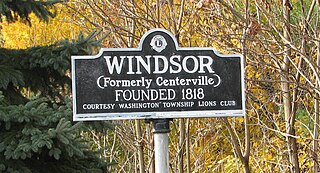
Windsor is a small historic unincorporated community and census-designated place (CDP) located within Robbinsville Township in Mercer County, in the U.S. state of New Jersey. The area is served as United States Postal Service ZIP Code 08561. As of the 2020 United States census, the CDP's population was 330, an increase of 104 (+46.0%) above the 226 counted at the 2010 census. The community, covering 570 acres (230 ha), was added to the National Register of Historic Places in 1992.
Condon is an unincorporated community and census-designated place in Missoula County, Montana, United States. Located along the Swan River and Montana Highway 83, Condon is situated between the Swan Range to the east and the Mission Mountains to the west, providing ready access to the Bob Marshall Wilderness and Mission Mountains Wilderness, respectively. Its population was 285 as of the 2020 United States census, down from 343 in 2010.
Turner is an unincorporated village in Blaine County, Montana, United States. Turner is located on Montana State Highway 241, 41.5 miles (66.8 km) east-northeast of Chinook. It is 12 miles south of the Canadian border. Its population was 61 as of the 2010 census.

Huson is a census-designated place and unincorporated community in Missoula County, Montana, United States. Its population was 210 as of the 2010 census. The community is located along Interstate 90 19 miles (31 km) northwest of Missoula.
Shawmut is a census-designated place and unincorporated community in Wheatland County, Montana, United States. Its population was 42 as of the 2010 census. Shawmut has a post office with ZIP code 59078, which opened on October 27, 1885. The community is located along U.S. Route 12 and Montana Highway 3.
Springdale is a census-designated place and unincorporated community in Park County, Montana, United States. Its population was 42 at the 2010 census. The community is located near Interstate 90 and the Yellowstone River. Springdale has its own ZIP code, 59082.
Crane is a census-designated place and unincorporated community in Richland County, Montana, United States. Its population was 102 according to the 2010 census. Crane has a post office with the ZIP code 59217. Montana Highway 16 passes through Crane.
Whitewater is a census-designated place and unincorporated community in Phillips County, Montana, United States. Its population was 64 as of the 2010 census. Whitewater has a post office with ZIP code 59544.
Brady is a census-designated place and unincorporated community in Pondera County, Montana, United States. Its population was 140 as of the 2010 census. Brady has a post office with ZIP code 59416. The community is located along Interstate 15.
Dupuyer is a census-designated place and unincorporated community in Pondera County, Montana, United States. Its population was 86 as of the 2010 census. The community is located along U.S. Route 89 and Dupuyer Creek. Dupuyer has a post office with ZIP code 59432.
Stockett is a census-designated place and unincorporated community in Cascade County, Montana, United States. Its population was 169 as of the 2010 census. Stockett has a post office with ZIP code 59480.
Kila is a census-designated place and unincorporated community in Flathead County, Montana, United States. Its population was 424 as of the 2020 census. Kila has a post office with ZIP code 59920, which opened on May 27, 1901. The community is located along U.S. Route 2, 10 miles from Kalispell.
Marion is a census-designated place and unincorporated community in Flathead County, Montana, United States. Its population was 1,119 as of the 2020 census. Marion has a post office with ZIP code 59925.
Olney is a census-designated place and unincorporated community in Flathead County, Montana, United States. Its population was 186 as of the 2020 census. Olney has a post office with ZIP code 59927. The most recent 2020 census states the population is 146 according to census.gov. The community is located along U.S. Route 93.
Lindsay is an unincorporated hamlet in Dawson County, Montana, United States, located on Montana Highway 200S and the Upper Sevenmile Creek, 22.3 miles (35.9 km) west-northwest of Glendive. The community has a post office with ZIP code 59339, a public school, and a cooperative.
Hall is an unincorporated community in Granite County, Montana, United States. Hall is located on Montana Highway 1, 6.2 miles (10.0 km) west-southwest of Drummond. The community has a post office with ZIP code 59837.
Helmville is an unincorporated community in Powell County, Montana, United States. Helmville is located in the central section of the county near Montana Highway 141, 13 miles (21 km) southeast of Ovando. The community has a post office with ZIP code 59843.
Canyon Creek is a small community of less than 200 citizens in Lewis and Clark County, Montana, United States. Canyon Creek is located along Secondary Highway 279, 18 miles (29 km) northwest of Helena. The community has an Antique and General Store with a U.S. Post Office, Volunteer Fire Station, Elementary School and a RV Park; it has a zip code of 59633.

Costilla is a census-designated place in Taos County, New Mexico, United States. Its population was 205 as of the 2010 census. Costilla has a post office with ZIP code 87524. State roads 196 and 522 intersect in the community.
Centerville is a census-designated place (CDP) in Cascade County, Montana, United States. It is in the east-central part of the county, in the valley of Cottonwood Creek where it joins Sand Coulee Creek, a north-flowing tributary of the Missouri River. Centerville lies along Secondary Highway 227, 2.5 miles (4.0 km) north of Stockett and 2 miles (3 km) south of Tracy. It is 14 miles (23 km) southeast of Great Falls via Highway 227 and U.S. Route 87.


