Sarah Mildred Long Bridge

Last updated

Sarah Mildred Long Bridge
Sarah Mildred Long Bridge (2018) 1.jpg
Seen from the New Hampshire side
Coordinates 43°05′12″N70°45′40″W / 43.086624°N 70.761052°W / 43.086624; -70.761052
CarriesBy-pass plate.svg
US 1.svg
US 1 Byp.
Crosses Piscataqua River
Locale Portsmouth, NH, and Kittery, ME
Official nameSarah Mildred Long Bridge
Owner NHDOT & MaineDOT
Maintained byMaine-New Hampshire Interstate Bridge Authority
Characteristics
Design Concrete lift bridge
Total length2,800 feet (850 m) [1]
Longest span300 feet (91 m) [1]
No. of lanes Two
Rail characteristics
No. of tracks One
Track gauge Standard
History
DesignerHardesty & Hanover
Engineering design byFigg Engineering
Constructed byCianbro Corp.
OpenedMarch 30, 2018
Location
Sarah Mildred Long Bridge

The Sarah Mildred Long Bridge is a lift bridge spanning the Piscataqua River between Portsmouth, New Hampshire, and Kittery, Maine, carrying traffic of U.S. Route 1 Bypass. An original bridge by the same name was in operation from 1940 until 2016. A replacement span opened in March 2018.

Contents

History

The original Sarah Mildred Long Bridge was the third span to carry motor vehicle traffic between Maine and New Hampshire at Portsmouth, replacing a river crossing at its location dating from 1822. [2] The bridge was the direct result of the work of the Maine-New Hampshire Interstate Bridge Authority, which had been formed in 1937. [3] The major goal of the bridge project was to relieve congestion in downtown Portsmouth and Kittery, where U.S. Route 1 crossed the river via the Memorial Bridge, which had opened in 1923. The bridge was completed in 1940, a decade and a half before the United States embarked on construction of an ambitious Interstate Highway System.

Original bridge

Original bridge
Sarah Mildred Long Bridge 01.jpg
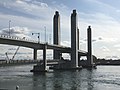
The original Sarah Mildred Long Bridge, as seen from Kittery, ME
Coordinates 43°05′09″N70°45′39″W / 43.0859°N 70.76091°W / 43.0859; -70.76091
CarriesBy-pass plate.svg
US 1.svg
US 1 Byp.
Crosses Piscataqua River
Locale Portsmouth, NH, and Kittery, ME
Official nameSarah Mildred Long Bridge
Maintained byMaine-New Hampshire Interstate Bridge Authority
ID number 021702510010800 [4]
Characteristics
Design Steel truss lift bridge
Total length854.7 m (2,804 ft)
Width9.1 m (29.9 ft)
Clearance above 5.09 m (16.7 ft)
Clearance below 41 m (134.5 ft) (Lift span open)
History
OpenedNovember 8, 1940 [5]
ClosedAugust 24, 2016
Statistics
Daily traffic 14,000 (2014)
14,900 (1990)
Location
Sarah Mildred Long Bridge

The original Sarah Mildred Long Bridge was a double-deck truss bridge, with a road deck above and a railroad bed below. Upon its dedication in 1940 the structure was simply known as the Maine-New Hampshire Bridge, later the Maine-New Hampshire (Interstate) Bridge. It was renamed in 1987 to honor Sarah Mildred Long, a 50-year employee of the Maine-New Hampshire Interstate Bridge Authority who rose from a secretary at its creation in 1937 to executive director.[ when? ] [6]

The bridge featured two separate movable spans, the central auto-bearing main lift and a retractable bridge for rail traffic near the Kittery shore. When not in use, the rail span lifted up and retracted south atop its own tracks inside the trusswork. The main span lifted on an as-needed basis for ocean-going commercial traffic, and on a varying set schedule for recreational craft unable to pass beneath the rail span, which was left in an open position by default to accommodate small boats and minimize interruption of auto traffic caused by raising the lift.

From 1960 until 1972, the U.S. Route 1 Bypass filled a gap in Interstate 95, linking traffic traveling the otherwise unconnected New Hampshire Turnpike and Maine Turnpike. Although most of the bypass is four lanes wide, the bridge had only a three-lane roadbed, with traffic on the center lane originally switching direction depending on load. This, combined with being a drawbridge, placed the bridge far below Interstate Highway standards. The turnpikes, and I-95, did not directly connect until the opening of the "high level" Piscataqua River Bridge and the extensions of I-95 leading to it in the early 1970s. In the decades leading to the bridge's closure, vehicular traffic had been reduced to just two lanes.

On October 12, 1989, a worker was killed when he was riding on a counterweight as the bridge closed and he was crushed against the bridge's superstructure. [7] [8]

On April 1, 2013, a large tanker struck the bridge, causing severe structural damage and leading to a temporary closure of vehicular traffic. [9] As the original Memorial Bridge had been closed in October 2011 and its replacement was under construction, the Piscataqua River Bridge was the only bridge between Kittery and Portsmouth remaining open. The bridge was repaired and re-opened to vehicle traffic on May 13, 2013. [10]

On August 21, 2016, the bridge became stuck in the closed position due to a mechanical failure after a shift in one of its trunnions caused a sheave and thrust block in the south tower to jam. On August 22, officials managed to partially raise the main span to allow shipping to pass under, which is given priority by federal law over road traffic. It was deemed unsafe to resume regular lifting, [11] [12] and with NHDOT and MaineDOT officials determining repairs would cost $1 million and take at least six weeks (and permanent closure just four weeks after the earliest possible re-opening), a decision was made to leave the span partially open until demolition. [11] The premature closure of the bridge was announced on August 24, 2016. [13]

Major demolition began with the overnight removal of the center span on October 14, 2016. [14] Removal of the bridge's towers followed, with a goal of removing both towers by November 18, 2016, [15] completed in April 2017.

Railroad

The railroad track that ran across the bridge was originally part of the Boston & Maine Railroad, which connected to South Berwick, Maine, via an easement that is now Maine Route 236. [16] In addition to replacing a vehicular span, the bridge absorbed the traffic of a railroad trestle located just upriver which had collapsed on September 10, 1939. [17] It had been weakened when a caisson used in the construction of the new bridge dragged its anchor cables, which pulled out several of the trestle's bents,[ clarification needed ] [18] sending B&M engine No. 3666 and a baggage car to the bottom of the river, where they remain. [19]

The tracks led to Kittery Junction, at which point one route split off towards York, Maine, on the York Harbor and Beach Railroad, while the other fork led to the Portsmouth Naval Shipyard in Kittery. The York Harbor and Beach branch was abandoned in 1925, [20] leaving only the shipyard branch still in service. That branch is primarily used for the transportation of nuclear materials. [21]

Present bridge

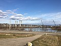
Construction of a $158.5 million replacement bridge began in January 2015, scheduled to open to traffic in September 2017. The original bridge had been set to close in November 2016, [22] but was moved up to August 21, 2016, by a mechanical problem that would have cost $1 million to repair. [12] [13] [11]

The new structure was designed by a joint venture of Hardesty & Hanover and Figg Engineering and constructed by Cianbro Corp. Rather than being constructed of structural steel, the bridge employs cantilevered, post-tensioned concrete spans, allowing eleven fewer piers than the original and an improved ability to absorb ship impact. Its vertical clearance of 56 feet (17 m) when closed to "IC-standard" is approximately 35 feet (11 m) higher than the original bridge, allowing an estimated 68% fewer openings. [11] The bridge deck also has wider shoulders for bicycle lanes.[ citation needed ]

An award of $25 million was made by the U.S. Department of Transportation for the railroad portion of the work, reflecting its role in supporting the Portsmouth Naval Shipyard downriver. [23] The result is a dual-purpose single 300-foot (91 m) lift span [24] with an integrated set of rails, which lowers to railroad level when rail traffic must cross.

The new bridge was scheduled to open on September 1, 2017, but construction delays pushed this back into 2018. Maine and New Hampshire's DOT officials maintain the bridge was "commissioned" in late January 2018 following several simulated lifting scenarios, allowing the states to take possession. [25] The replacement bridge was officially opened on March 30, 2018. [26] [27]

In March 2019, the project was recognized as New Hampshire's most outstanding engineering achievement of the prior year by the American Council of Engineering Companies (ACEC). [28] The project was also one of 16 finalists for ACEC's national award. [29]

Original bridge

Present bridge

See also

Related Research Articles

<span class="mw-page-title-main">Portsmouth, New Hampshire</span> City in Rockingham County, New Hampshire

Portsmouth is a city in Rockingham County, New Hampshire, United States. At the 2020 census it had a population of 21,956. A historic seaport and popular summer tourist destination on the Piscataqua River bordering the state of Maine, Portsmouth was formerly the home of the Strategic Air Command's Pease Air Force Base, since converted to Portsmouth International Airport at Pease.

<span class="mw-page-title-main">Eliot, Maine</span> Town in Maine, United States

Eliot is a town in York County, Maine, United States. Originally settled in 1623, it was formerly a part of Kittery, to its east. After Kittery, it is the next most southern town in the state of Maine, lying on the Piscataqua River across from Portsmouth and Newington, New Hampshire. The population was 6,717 at the 2020 census. It is part of the Portland–South Portland–Biddeford, Maine metropolitan statistical area.

<span class="mw-page-title-main">Kittery, Maine</span> Town in the state of Maine, United States

Kittery is a town in York County, Maine, United States, and the oldest incorporated town in Maine. Home to the Portsmouth Naval Shipyard on Seavey's Island, Kittery includes Badger's Island, the seaside district of Kittery Point, and part of the Isles of Shoals. The southernmost town in the state, it is a tourist destination known for its many outlet stores.

<span class="mw-page-title-main">Piscataqua River</span> River in Maine and New Hampshire, United States

The Piscataqua River is a 12-mile-long (19 km) tidal river forming the boundary of the U.S. states of New Hampshire and Maine from its origin at the confluence of the Salmon Falls River and Cochecho River to the Atlantic Ocean. The drainage basin of the river is approximately 1,495 square miles (3,870 km2), including the subwatersheds of the Great Works River and the five rivers flowing into Great Bay: the Bellamy, Oyster, Lamprey, Squamscott, and Winnicut.

<span class="mw-page-title-main">Seacoast Region (New Hampshire)</span>

The Seacoast Region is the southeast area of the U.S. state of New Hampshire that is centered around the city of Portsmouth. It includes the eastern portion of Rockingham County and the southern portion of Strafford County. At its narrowest definition, the region stretches 13 miles (21 km) along the Atlantic Ocean from New Hampshire's border with Salisbury, Massachusetts, to the Piscataqua River and New Hampshire's border with Kittery, Maine. The shoreline alternates between rocky and rough headlands and areas with sandy beaches. Some of the beaches are bordered by jetties or groins, particularly in the towns of Rye and Hampton. Most definitions of the Seacoast Region includes some inland towns as well, including the Great Bay area cities of Dover and Rochester, the college town of Durham, and areas as far west as Epping. Some definitions also include nearby portions of York County, Maine that are culturally aligned with the Portsmouth area rather than the Portland, Maine metropolitan area.

<span class="mw-page-title-main">Waldo–Hancock Bridge</span> Bridge in Bucksport, Maine

The Waldo–Hancock Bridge was the first long-span suspension bridge erected in Maine, as well as the first permanent bridge across the Penobscot River downstream from Bangor. The name comes from connecting Waldo and Hancock counties. The bridge was built in 1931 and retired in 2006, when the new Penobscot Narrows Bridge was opened just a few yards away, and it was demolished in 2013.

<span class="mw-page-title-main">Interstate 95 in Maine</span> Section of Interstate Highway in Maine, United States

Interstate 95 (I-95) is a part of the Interstate Highway System that runs north–south from Miami, Florida to Houlton, Maine. The highway enters Maine from the New Hampshire state line in Kittery and runs for 303 miles (488 km) to the Canada–United States border at Houlton. It is the only primary Interstate Highway in Maine. In 2004, the highway's route between Portland and Gardiner was changed so that it encompasses the entire Maine Turnpike, a toll road running from Kittery to Augusta.

<span class="mw-page-title-main">Interstate 95 in New Hampshire</span> Interstate Highway in New Hampshire, United States

Interstate 95 (I-95) is an Interstate Highway on the east coast of the United States, connecting Florida to Maine. Within the state of New Hampshire, it serves the Seacoast Region and is a toll road named the Blue Star Turnpike or New Hampshire Turnpike. The 16-mile (26 km) turnpike is maintained by the New Hampshire Department of Transportation (NHDOT) Bureau of Turnpikes and has a single toll plaza near Hampton.

<span class="mw-page-title-main">U.S. Route 1 Bypass (Portsmouth, New Hampshire–Kittery, Maine)</span>

U.S. Route 1 Bypass is a 4.3-mile-long (6.9 km) bypass of U.S. Route 1 in Portsmouth, New Hampshire and Kittery, Maine. Most of its north section, northeast of the Portsmouth Traffic Circle where it meets the Blue Star Turnpike and Spaulding Turnpike, is built to rudimentary freeway standards, with no cross traffic but driveway access. The southern portion is similarly constructed, although there are two four-way intersections with traffic lights just south of the circle and a third at its south end, just before intersecting with US 1.

The Portsmouth Traffic Circle is a four-point rotary in the city of Portsmouth, New Hampshire.

<span class="mw-page-title-main">Piscataqua River Bridge</span> Bridge in Portsmouth, New Hampshire and Kittery, Maine

The Piscataqua River Bridge is a through arch bridge that crosses the Piscataqua River, connecting Portsmouth, New Hampshire with Kittery, Maine, United States. Carrying six lanes of Interstate 95, the bridge is the third modern span and first fixed crossing of the Piscataqua between Portsmouth and Kittery. The two other spans, the Memorial Bridge and the Sarah Mildred Long Bridge, are both lift bridges, built to accommodate ship traffic along the Piscataqua. The high arch design of the Piscataqua River Bridge eliminates the need for a movable roadway.

<span class="mw-page-title-main">Memorial Bridge (Portsmouth, New Hampshire)</span> Vertical-lift bridge across the Piscataqua River

The World War I Memorial Bridge is a vertical-lift bridge that carries U.S. Route 1 across the Piscataqua River between Portsmouth, New Hampshire, and Badger's Island in Kittery, Maine, United States. The current bridge was opened in 2013, replacing a bridge of similar design that existed from 1923 to 2012. A large overhead plaque carried over from the original reads "Memorial to the Sailors and Soldiers of New Hampshire who gave their lives in the World War 1917–1919."

<span class="mw-page-title-main">Little Bay Bridge</span> Bridge in Dover and Newington, New Hampshire

The Little Bay Bridge, or Little Bay Bridges, are a pair of four-lane girder bridges that carry a concurrency of U.S. Route 4, NH Route 16, and the Spaulding Turnpike across the mouth of Little Bay where it meets the Piscataqua River, between the city of Dover and the town of Newington in New Hampshire. As of August 2019, the bridges carry seven motor vehicle lanes with four shoulders, and one non-motorized multi-use path while the General Sullivan Bridge is closed.

<span class="mw-page-title-main">U.S. Route 1 in New Hampshire</span>

U.S. Route 1 (US 1) is a north–south U.S. Route is the U.S. state of New Hampshire through Hampton and Portsmouth. It lies between Interstate 95 (I-95) and New Hampshire Route 1A (NH 1A).

<span class="mw-page-title-main">Gundalow</span> Type of New England sailing barge

A gundalow is a type of flat-bottomed sailing barge once common in Maine and New Hampshire rivers, United States. It first appeared in the mid-1600s, reached maturity of design in the 1700 and 1800s, and lingered into the early 1900s before nearly vanishing as a commercial watercraft.

<span class="mw-page-title-main">Maine State Route 103</span> State highway in York County, Maine, US

State Route 103 (SR 103) is a 16.3-mile (26.2 km) long state highway in extreme southern Maine. The route is signed east–west, but forms a half-loop, with most of its western segment running strongly southeast slightly inland of the Piscataqua River and the state border with New Hampshire, its central skirting the Piscataqua generally easterly, and its eastern strongly northeast slightly inland from the Atlantic Ocean. The route piggybacks on different roads with many turns throughout its length.

<span class="mw-page-title-main">Badger's Island</span> Small island in Maine

Badger's Island is located in the Piscataqua River at Kittery, Maine, United States, directly opposite Portsmouth, New Hampshire. It carries U.S. Route 1 between the states, connecting to the Kittery mainland by the Badger's Island Bridge, and to New Hampshire by the Memorial Bridge. Now largely a suburb of Portsmouth, the island features houses, condominiums, restaurants and marinas.

<span class="mw-page-title-main">Arch Bridge (Bellows Falls)</span> Bridge in Vermont to North Walpole, New Hampshire

The Bellows Falls Arch Bridge was a three-hinged steel through arch bridge over the Connecticut River between Bellows Falls, Vermont and North Walpole, New Hampshire. It was structurally significant as the longest arch bridge in the United States when it was completed in 1905.

<span class="mw-page-title-main">Contoocook Railroad Bridge</span> United States historic place

The Contoocook Railroad Bridge is a covered bridge on the former Contoocook Valley Railroad line spanning the Contoocook River in the center of the village of Contoocook, New Hampshire, United States. It is referred to in the National Register of Historic Places as the Hopkinton Railroad Covered Bridge, for the town of Hopkinton, New Hampshire, in which the village of Contoocook is located.

References

  1. 1 2 "Sarah Mildred Long Bridge Replacement". cianbro.com. Retrieved April 2, 2018.
  2. "Summary of The Sarah Mildred Long Bridge: A History of the Maine-New Hampshire Interstate Bridge from Portsmouth, New Hampshire, to Kittery, Maine". nh.gov. Retrieved October 2, 2006.
  3. "Bill for New Bridge Signed by President". The Portsmouth Herald . Portsmouth, New Hampshire. July 29, 1937. p. 1. Retrieved March 31, 2018 via newspapers.com.
  4. Nationalbridges.com. "National Bridge Inventory Bridges - 021702510010800". Archived from the original on September 27, 2007. Retrieved September 29, 2006.
  5. "New Interstate Bridge Opened". Fitchburg Sentinel . Fitchburg, Massachusetts. AP. November 8, 1940. p. 4. Retrieved March 31, 2018 via newspapers.com.
  6. "Portsmouth Herald Obituaries from: Tuesday, March 2, 2004". Archived from the original on April 27, 2006. Retrieved October 2, 2006.
  7. "FIRM CITED BEFORE WORKER'S DEATH" . The Boston Globe . October 25, 1989. p. 33. Retrieved March 31, 2018 via pqarchiver.com.
  8. "Bridge operator places blame on victim". The Burlington Free Press . Burlington, Vermont. AP. October 21, 1989. p. 15. Retrieved March 31, 2018 via newspapers.com.
  9. "Sarah Long Bridge sustains 'severe structural damage' in crash, DOT says; Bridge closed to vehicular traffic after incident". WMUR-9. Retrieved April 2, 2013.
  10. McDermott, Deborah (May 14, 2013). "Sarah Mildred Long Bridge reopens ahead of schedule". Seacoast Online. Retrieved August 24, 2016.
  11. 1 2 3 4 "A Maine-N.H. Lift Span Retires Early Due to Stuck Sheave". Engineering News-Record. bnp media. September 5–12, 2016.
  12. 1 2 DeCosta-Klipa, Nik. "New Hampshire lift bridge to Maine stuck in raised position, may not ever come down". Boston Globe. Retrieved August 23, 2016.
  13. 1 2 "Sarah Long Bridge permanently closed to traffic". WGME-TV. August 24, 2016. Retrieved August 24, 2016.
  14. Tranchemontagne, Cam (October 15, 2016). "DOT Crews remove middle section of Sarah Mildred Long Bridge". WMUR-TV. Retrieved October 22, 2016.
  15. Early, Brian. "Removal of Sarah Long Bridge's lift towers begins". Seacoast Online. Seacoast Media Group. Retrieved October 22, 2016.
  16. "Eliot History Time Line". Old Berwick Historical Society. March 16, 2001. Retrieved March 31, 2018.
  17. "Train Wreck Takes Two Lives". The Portsmouth Herald . Portsmouth, New Hampshire. September 11, 1939. p. 1. Retrieved March 31, 2018 via newspapers.com.
  18. "Boston & Maine Train Accident 1939 Portsmouth NH". Archived from the original on December 22, 2021. Retrieved March 31, 2018 via YouTube.
  19. "TrainWreck #3666, in the Piscataqua River, NH". Archived from the original on December 22, 2021. Retrieved March 31, 2018 via YouTube.
  20. "York Beach Branch is to be Closed by B&M Next Month". The Portsmouth Herald . Portsmouth, New Hampshire. May 15, 1925. p. 1. Retrieved March 31, 2018 via newspapers.com.
  21. "Cianbro Prepares for Milestone Project to Replace Sarah Mildred Long Bridge". cianbro.com. September 26, 2014. Retrieved March 31, 2018.
  22. Nadeau, Gregory (January 6, 2015). "Breaking ground: A new year, a new bridge". FHWA. US Government. Archived from the original on November 19, 2016. Retrieved August 24, 2016.
  23. Koeing, Seth (September 25, 2014). "States agree on price for Kittery-Portsmouth bridge replacement". Bangor Daily News . Retrieved September 25, 2014.
  24. "Sarah Mildred Long Bridge Replacement, New Hampshire". roadtraffic-technology.com. Retrieved March 31, 2018.
  25. Portsmouth Herald Staff (February 9, 2018). "State officials rebut 'rumors' that new $170M bridge is unsafe". Bangor Daily News. Retrieved February 9, 2018.
  26. "New bridge between Maine, New Hampshire opens to traffic". Boston.com . AP. March 30, 2018. Retrieved March 31, 2018.
  27. LaCasse, Alex (March 30, 2018). "Sarah Long Bridge opens to traffic amid dispute". seacoastonline.com . Retrieved March 31, 2018.
  28. "Sarah Mildred Long Bridge Wins Top Prize at ACEC NH Engineering Excellence Awards Ceremony". hardestyhanover.com. March 28, 2019. Retrieved July 11, 2019.
  29. "2019 Gala Evening". American Council of Engineering Companies. May 7, 2019. Retrieved July 11, 2019 via docs.acec.org.

Further reading