Related Research Articles
GLONASS is a Russian satellite navigation system operating as part of a radionavigation-satellite service. It provides an alternative to Global Positioning System (GPS) and is the second navigational system in operation with global coverage and of comparable precision.
Iridium Communications Inc. is a publicly traded American company headquartered in McLean, Virginia, United States. Iridium operates the Iridium satellite constellation, a system of 75 satellites: 66 are active satellites and the remaining nine function as in-orbit spares. Iridium Satellites are used for worldwide voice and data communication from handheld satellite phones, satellite messenger communication devices and integrated transceivers, as well as for two-way satellite messaging service from supported conventional mobile phones. The nearly polar orbit and communication between satellites via inter-satellite links provide global service availability.

An emergency position-indicating radiobeacon (EPIRB) is a type of emergency locator beacon for commercial and recreational boats, a portable, battery-powered radio transmitter used in emergencies to locate boaters in distress and in need of immediate rescue. In the event of an emergency, such as a ship sinking or medical emergency onboard, the transmitter is activated and begins transmitting a continuous 406 MHz distress radio signal, which is used by search-and-rescue teams to quickly locate the emergency and render aid. The signal is detected by satellites operated by an international consortium of rescue services, COSPAS-SARSAT, which can detect emergency beacons anywhere on Earth transmitting on the distress frequency of 406 MHz. The satellites calculate the position or utilize the GPS coordinates of the beacon and quickly passes the information to the appropriate local first responder organization, which performs the search and rescue. As Search and Rescue approach the search areas, they use Direction Finding (DF) equipment to locate the beacon using the 121.5 MHz homing signal, or in newer EPIRBs, the AIS location signal. The basic purpose of this system is to help rescuers find survivors within the so-called "golden day" during which the majority of survivors can usually be saved. The feature distinguishing a modern EPIRB, often called GPIRB, from other types of emergency beacon is that it contains a GPS receiver and broadcasts its position, usually accurate within 100 m (330 ft), to facilitate location. Previous emergency beacons without a GPS can only be localized to within 2 km (1.2 mi) by the COSPAS satellites and relied heavily upon the 121.5 MHz homing signal to pin-point the beacons location as they arrived on scene.
Ultra high frequency (UHF) is the ITU designation for radio frequencies in the range between 300 megahertz (MHz) and 3 gigahertz (GHz), also known as the decimetre band as the wavelengths range from one meter to one tenth of a meter. Radio waves with frequencies above the UHF band fall into the super-high frequency (SHF) or microwave frequency range. Lower frequency signals fall into the VHF or lower bands. UHF radio waves propagate mainly by line of sight; they are blocked by hills and large buildings although the transmission through building walls is strong enough for indoor reception. They are used for television broadcasting, cell phones, satellite communication including GPS, personal radio services including Wi-Fi and Bluetooth, walkie-talkies, cordless phones, satellite phones, and numerous other applications.

A pager, also known as a beeper or bleeper, is a wireless telecommunications device that receives and displays alphanumeric or voice messages. One-way pagers can only receive messages, while response pagers and two-way pagers can also acknowledge, reply to, and originate messages using an internal transmitter.
A distress signal, also known as a distress call, is an internationally recognized means for obtaining help. Distress signals are communicated by transmitting radio signals, displaying a visually observable item or illumination, or making a sound audible from a distance.
The Global Maritime Distress and Safety System (GMDSS) is a worldwide system for automated emergency signal communication for ships at sea developed by the United Nations' International Maritime Organization (IMO) as part of the SOLAS Convention.

A satellite telephone, satellite phone or satphone is a type of mobile phone that connects to other phones or the telephone network by radio link through satellites orbiting the Earth instead of terrestrial cell sites, as cellphones do. Therefore, they can work in most geographic locations on the Earth's surface, as long as open sky and the line-of-sight between the phone and the satellite are provided. Depending on the architecture of a particular system, coverage may include the entire Earth or only specific regions. Satellite phones provide similar functionality to terrestrial mobile telephones; voice calling, text messaging, and low-bandwidth Internet access are supported through most systems. The advantage of a satellite phone is that it can be used in such regions where local terrestrial communication infrastructures, such as landline and cellular networks, are not available.
The aircraft emergency frequency is a frequency used on the aircraft band reserved for emergency communications for aircraft in distress. The frequencies are 121.5 MHz for civilian, also known as International Air Distress (IAD), International Aeronautical Emergency Frequency, or VHF Guard, and 243.0 MHz—the second harmonic of VHF guard—for military use, also known as Military Air Distress (MAD), NATO Combined Distress and Emergency Frequency, or UHF Guard. Earlier emergency locator transmitters used the guard frequencies to transmit. As of February 1, 2009 satellite monitoring of the 121.5 and 243 MHz ELT (EPIRB) frequencies ceased, whereas an additional band from 406.0 to 406.1 MHz is now used exclusively by modern emergency locator transmitters (EPIRB).

The automatic identification system (AIS) is an automatic tracking system that uses transceivers on ships and is used by vessel traffic services (VTS). When satellites are used to receive AIS signatures, the term Satellite-AIS (S-AIS) is used. AIS information supplements marine radar, which continues to be the primary method of collision avoidance for water transport. Although technically and operationally distinct, the ADS-B system is analogous to AIS and performs a similar function for aircraft.
The International Cospas-Sarsat Programme is a satellite-aided search and rescue (SAR) initiative. It is organized as a treaty-based, nonprofit, intergovernmental, humanitarian cooperative of 45 nations and agencies. It is dedicated to detecting and locating emergency locator radio beacons activated by persons, aircraft or vessels in distress, and forwarding this alert information to authorities that can take action for rescue. Member countries support the distribution of distress alerts using a constellation of around 65 satellites orbiting the Earth which carry transponders and signal processors capable of locating an emergency beacon anywhere on Earth transmitting on the Cospas-Sarsat frequency of 406 MHz.
A GPS tracking unit, geotracking unit, satellite tracking unit, or simply tracker is a navigation device normally on a vehicle, asset, person or animal that uses satellite navigation to determine its movement and determine its WGS84 UTM geographic position (geotracking) to determine its location. Satellite tracking devices may send special satellite signals that are processed by a receiver.

A fire alarm system is a building system designed to detect, alert occupants, and alert emergency forces of the presence of fire, smoke, carbon monoxide, or other fire-related emergencies. Fire alarm systems are required in most commercial buildings. They may include smoke detectors, heat detectors, and manual fire alarm activation devices. All components of a fire alarm system are connected to a fire alarm control panel. Fire alarm control panels are usually found in an electrical or panel room. Fire alarm systems generally use visual and audio signalization to warn the occupants of the building. Some fire alarm systems may also disable elevators, which are unsafe to use during a fire under most circumstances.
The Radio Technical Commission for Maritime Services (RTCM) is a non-profit international standards organization. Although started in 1947 as a U.S. government advisory committee, RTCM is now an independent organization supported by its member organizations from all over the world.
A Mountain Locator Unit or MLU was a radio transmitter for use by mountain climbers as an emergency locator beacon when the wearer needs rescue.

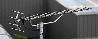
In navigation, a radio beacon or radiobeacon is a kind of beacon, a device that marks a fixed location and allows direction-finding equipment to find relative bearing. But instead of employing visible light, radio beacons transmit electromagnetic radiation in the radio wave band. They are used for direction-finding systems on ships, aircraft and vehicles.

Radio is the technology of communicating using radio waves. Radio waves are electromagnetic waves of frequency between 3 hertz (Hz) and 300 gigahertz (GHz). They are generated by an electronic device called a transmitter connected to an antenna which radiates oscillating electrical energy, often characterized as a wave. They can be received by other antennas connected to a radio receiver, this is the fundamental principle of radio communication. In addition to communication, radio is used for radar, radio navigation, remote control, remote sensing, and other applications.
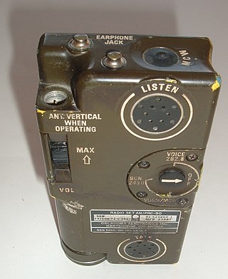
Survival radios are carried by pilots and search and rescue teams to facilitate rescue in an emergency. They are generally designed to transmit on international distress frequencies. Maritime systems have been standardized under the Global Maritime Distress Safety System. Civil and military organisation's utilized different frequencies to communicate and no infringement on either sector would take place. For emergencies involving civilian aircraft, the radio frequency used is VHF 121.5 MHz and for military aircraft incidents, the frequency used is UHF 243 MHz.
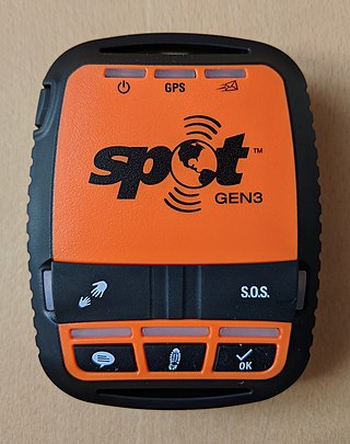
SPOT is a GPS tracking device that uses the Globalstar satellite network to provide text messaging and GPS tracking. It has a coverage area that includes a large portion of the planet, with the exception of extreme northern and southern latitudes and parts of the Pacific Ocean. Depending on the product, SPOT can send and receive communications.
An emergency locator beacon is a radio beacon, a portable battery powered radio transmitter, used to locate airplanes, vessels, and persons in distress and in need of immediate rescue. Various types of emergency locator beacons are carried by aircraft, ships, vehicles, hikers and cross-country skiers. In case of an emergency, such as the aircraft crashing, the ship sinking, or a hiker becoming lost, the transmitter is deployed and begins to transmit a continuous radio signal, which is used by search and rescue teams to quickly find the emergency and render aid. The purpose of all emergency locator beacons is to help rescuers find survivors within the so-called "golden day", the first 24 hours following a traumatic event, during which the majority of survivors can usually be saved.
References
- ↑ Yellowbrick two-way messenger datasheet
- ↑ GEOS Search and Rescue
- ↑ NSARC minutes from December 2009
- ↑ Emerging technologies in commercially available alerting devices from ICAO/IMO JOINT WORKING GROUP, October 2009
- ↑ NATIONAL GMDSS IMPLEMENTATION TASK FORCE
- ↑ SPOT Satellite Messenger FIRST LOOK – EQUIPPED TO SURVIVE (tm)
- ↑ SPOT Emergency Response
- ↑ How SPOT works
- ↑ Yellowbrick Website Archived 2014-07-22 at the Wayback Machine
https://www.garmin.com/en-US/blog/outdoor/get-to-know-garmin-response/