Scaftworth

Last updated

Scaftworth
Civil parish
Scaftworth Hall (geograph 4803601).jpg
Scaftworth Hall
Scaftworth
Parish map
Nottinghamshire UK location map.svg
Red pog.svg
Scaftworth
Location within Nottinghamshire
Area1.66 sq mi (4.3 km2)
Population44 (Census 2021)
  Density 27/sq mi (10/km2)
OS grid reference SK 66474 91708
  London 135 mi (217 km)  SE
District
Shire county
Region
Country England
Sovereign state United Kingdom
Post town DONCASTER
Postcode district DN10
Dialling code 01302
Police Nottinghamshire
Fire Nottinghamshire
Ambulance East Midlands
UK Parliament
List of places
UK
England
Nottinghamshire
53°25′05″N1°00′04″W / 53.418°N 1.001°W / 53.418; -1.001

Scaftworth is a hamlet and civil parish within the Bassetlaw district of north Nottinghamshire, England.

Contents

Geography

The area is 1 mile south east of Bawtry, 10 miles north east of Worksop, and 33 miles north of Nottingham.

Within Nottinghamshire, Misson bounds Scaftworth to the north east, Scrooby to the south west, Mattersey to the south, Everton to the east.

Austerfield and Bawtry, both in the county of South Yorkshire lie to the north and west.

The A631 Sheffield-Gainsborough-Louth road passes through the parish, with the settlement itself some 200–400 metres away from the road. The A631 bypass was built in 1936. [1]

Predominantly, the parish is a scattering of farms, farmhouses and cottages amongst a wider rural setting. The core centre residences are mainly grouped around a village only access road called Village Street to the south of the A631 road.

The area is very low-lying at nearly sea level, with the exception of the area around Scaftworth Hall at 10 metres (33 ft) and Barrow Hills at 40 metres (130 ft). Forested areas include Cobblety Row and Ling's Wood to the south of the village, and Barrow Hills to the east.

The River Idle forms the western and northern boundary of the parish, as well as the county border, and runs alongside the village area. Due to the overall low elevation, the area is well known for flooding during periods of high rainfall because of the river's proximity, although this has been alleviated somewhat in recent years with flood prevention schemes in place further along the river, [2] notably the Barrier Bank in the north of the parish, and a Mother Drain running alongside, which allow the low-lying areas to be drained for agriculture.

Governance and demography

For 2021 census purposes, Scaftworth's population is reported as totalling 44 people. [3]

Bassetlaw district council administer the next tier of services, with Nottinghamshire County Council actioning the highest level of local public duties.

The core of the village has a conservation area designation by the district council which restricts inappropriate development. [4] [5]

History

Toponymy

The place name Scaftworth is possibly derived from 'Skapti's enclosure'. If there was a person named as such in local history, it is unclear. [6] It was recorded in 1086 within the Domesday Book as Scafteorde. [7]

Heritage

The wider area contains a wealth of archaeology, with various artefacts being found, likely relating to local Roman occupation. [8] By the time of the Domesday Book, the landowner was the Archbishop of York. [9] By the 18th century he was still getting quit rent on these lands, from Richard Acklom who was by then the main landowner and Lord of the Manor. There were other small holdings for Bawtry chapel on lease to the Duke of Newcastle, and for the Vicar of Everton parish. [8] It was associated as being a township of the neighbouring Everton parish. The common land was enclosed in 1772–3.

The A631 road follows the route of an old Roman road. The village was bypassed by an 0.3 mile extension in 1937. [10] Bawtry Road Bridge was built in 1810 and widened in 1940. This is the present boundary of the parish and Nottinghamshire, with Bawtry and South Yorkshire. [11]

Bawtry railway viaduct was previously within Scaftworth parish until the parish/county boundaries were moved further inward in 1991 to follow the changed river alignment over the railway cut. [12] This cut was built by the Great Northern Railway in 1849 to allow continued river navigation, and the railway presently is used for the East Coast Main Line (Kings Cross to Edinburgh). Train speeds are restricted to 115 mph across the viaduct because of the boggy ground alongside the river. [13]

Scaftworth Hall

Scaftworth is an estate village associated with Scaftworth Hall from the 18th century. In 1835, the manor comprised the whole township as under the Viscount Althorp (3rd Earl Spencer) acquired through marriage into the Acklom family who owned estates at nearby Wiseton and Everton. All were sold in 1848. [14]

Roman fort and road

A fort was in place 300 metres (980 ft) east of Bawtry Bridge in the 4th century AD. Earthworks were still in place until at least 1770 when these were added to John Chapman's map of Nottinghamshire. [15] White's Directory of 1835 also confirmed that there were Roman artefacts found locally, [16] but the field had been farmed over since and the location forgotten. Rediscovery took place in the 1940s when aerial surveying of the area took place, with the elevation of the crops on the land betraying the layout of the fort, [17] excavations confirmed the fort and scheduled monument designation was subsequently placed on the site. A Roman road layout was also determined as being north of the site, and this has also been added into the designation. [18] [19]

Facilities

Farming is the key industry with much of the available land and buildings used to support this activity.

There is one public house, named The King William.

Protected locations

Related Research Articles

<span class="mw-page-title-main">Nottinghamshire</span> County of England

Nottinghamshire is a ceremonial county in the East Midlands of England. The county borders South Yorkshire to the north-west, Lincolnshire to the east, Leicestershire to the south, and Derbyshire to the west. The largest settlement is the city of Nottingham (323,632).

<span class="mw-page-title-main">Bawtry</span> Market town in South Yorkshire, England

Bawtry is a market town and civil parish in the City of Doncaster in South Yorkshire, England. It lies 8 miles (13 km) south-east of Doncaster, 10 miles (16 km) west of Gainsborough and 8 miles (13 km) north-west of Retford, on the border with Nottinghamshire and close to Lincolnshire. The town was historically divided between the West Riding of Yorkshire and Nottinghamshire. Its population of 3,204 in the 2001 UK census increased to 3,573 in 2011, and was put at 3,519 in 2019. Nearby settlements include Austerfield, Everton, Scrooby, Blyth, Bircotes and Tickhill.

<span class="mw-page-title-main">West Lindsey</span> District in England

West Lindsey is a local government district in Lincolnshire, England. Its council is based in Gainsborough, the district's largest town. The district also includes the towns of Caistor and Market Rasen, along with numerous villages and surrounding rural areas. The east of the district includes part of the Lincolnshire Wolds, a designated Area of Outstanding Natural Beauty.

<span class="mw-page-title-main">Bassetlaw District</span> Northernmost district of Nottinghamshire, England

Bassetlaw is a local government district in north Nottinghamshire, England. Its council is based in the town of Worksop; the other towns in the district are Retford, Tuxford and Harworth Bircotes. The district also contains numerous villages and surrounding rural areas.

<span class="mw-page-title-main">River Idle</span> River in Nottinghamshire, England

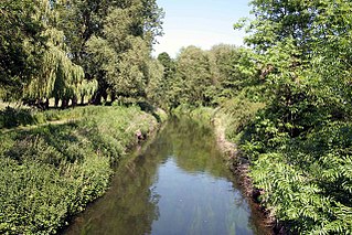
The River Idle is a river in Nottinghamshire, England whose source is the confluence of the River Maun and River Meden near Markham Moor. The Idle flows north from its source through Retford and Bawtry before entering the River Trent at West Stockwith. Its main tributaries are the River Poulter and the River Ryton. The river is navigable to Bawtry, and there is a statutory right of navigation to Retford. Most of the land surrounding the river is a broad flood plain and the river is important for conservation, with Sites of Special Scientific Interest being designated along its course.

<span class="mw-page-title-main">Finningley</span> Village and civil parish in South Yorkshire, England

Finningley is a village and civil parish in the City of Doncaster, South Yorkshire, England. Historically in Nottinghamshire, it lies on the A614 road between Bawtry and Thorne, about 6 miles south-east of Doncaster. In the 2011 census, it had a population of 1,497. The Finningley ward of Doncaster Metropolitan Borough Council covers 16.8 square miles, including the villages of Auckley, Branton, Blaxton, Hayfield and Bessacarr Grange, and part of Cantley.

<span class="mw-page-title-main">Rossington</span> Civil parish and former mining village in South Yorkshire, England

Rossington is a civil parish and former mining village in the Metropolitan Borough of Doncaster in South Yorkshire, England and is surrounded by countryside and the market towns of Bawtry and Tickhill.

<span class="mw-page-title-main">A638 road</span> Road in England

The A638 is a major road in England. It runs between the A1 at Markham Moor, Nottinghamshire and Chain Bar Interchange – Junction 26 of the M62 motorway, south of Bradford in West Yorkshire.

<span class="mw-page-title-main">A631 road</span> Road in England

The A631 is a road running from Sheffield, South Yorkshire to Louth, Lincolnshire in England. It passes through the counties of South Yorkshire, Nottinghamshire and Lincolnshire. The road has many towns on its route including Rotherham, Maltby, Gainsborough and Market Rasen. It is mostly single road throughout its length but has some stretches of dual carriageway as well.

<span class="mw-page-title-main">Everton, Nottinghamshire</span> Human settlement in England

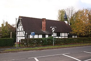
Everton is a village and civil parish in Nottinghamshire, England. Located on the A631 between Gainsborough and Bawtry, it is part of Bassetlaw district. The parish includes the village of Harwell. The population of the civil parish at the 2011 census was 839. There are 23 grade II listed buildings in the village. The village is recorded in the Domesday Book of 1086–7 as Evretone. Everton was originally a Danish settlement by the name of Eofor-tun. For the majority of its history Everton's inhabitants have been farmers.
Everton is twinned with the French village of Bouy in Champagne Ardenne, France.

<span class="mw-page-title-main">Welham, Nottinghamshire</span> Settlement in Nottinghamshire, England

Welham is a hamlet in the civil parish of Clarborough and Welham, of Bassetlaw district, in the county of Nottinghamshire, England. It is 130 miles north of London, 28 miles north east of the city of Nottingham, and 2 miles north east of the market town of Retford.

<span class="mw-page-title-main">Harwell, Nottinghamshire</span> Human settlement in England

Harwell is a hamlet in the civil parish of Everton, in Bassetlaw district, northern Nottinghamshire, England. It is located off the A631 road, less than a mile to the northwest of Everton and three miles northeast of Bawtry. Although only a small settlement, historically Harwell had a separate manor. The hamlet had a population of 112 people in the mid 19th century and the Corporation of Newark were lords of the manor at that time. Today, the main feature of Harwell is the Grade II listed Pear Tree House and the Barrow Hills woodland, immediately to the northwest.

<span class="mw-page-title-main">A1500 road</span> Road in Lincolnshire, England

The A1500 is an 'A' road entirely within the English county of Lincolnshire. It links the A156 at Marton with the A15 south of RAF Scampton via Sturton by Stow.

<span class="mw-page-title-main">Hodsock</span> Settlement and civil parish in Nottinghamshire, England

Hodsock is a settlement and civil parish about 4 miles from Worksop, in the Bassetlaw district, in the county of Nottinghamshire, England. The parish includes the village of Langold and the country house Hodsock Priory. In 2021 the parish had a population of 2,603. The parish is surrounded by the settlements of Babworth, Barnby Moor, Blyth, Carlton in Lindrick, Costhorpe, Firbeck, Letwell, Maltby, Styrrup with Oldcotes and Torworth.

<span class="mw-page-title-main">Styrrup with Oldcotes</span> Civil parish in England

Styrrup with Oldcotes is a civil parish in the Bassetlaw district, within the county of Nottinghamshire, England. The overall area had a population of 731 at the 2021 census, an increase from 684 at the 2011 census. The parish lies in the north of the county. It is 138 miles north west of London, 31 miles north of the city of Nottingham, and 15 miles east of the city of Sheffield. The parish rests alongside the county border with South Yorkshire.

<span class="mw-page-title-main">Headon, Nottinghamshire</span> Human settlement in England

Headon is a village in Headon cum Upton civil parish, in the Bassetlaw district, of the county of Nottinghamshire, England. The village is adjacent to the villages of Upton, Nether Headon, East Drayton, Eaton, Gamston, Woodbeck and Stokeham. In 2011 the parish, together with Stokeham had a population of 253. The area is 3.5 miles south east of the nearest market town Retford, 26 miles north east of the county town Nottingham and 125 miles north of London. There are 2 listed buildings in Headon village.

<span class="mw-page-title-main">South Wheatley, Nottinghamshire</span> Settlement in Nottinghamshire, England

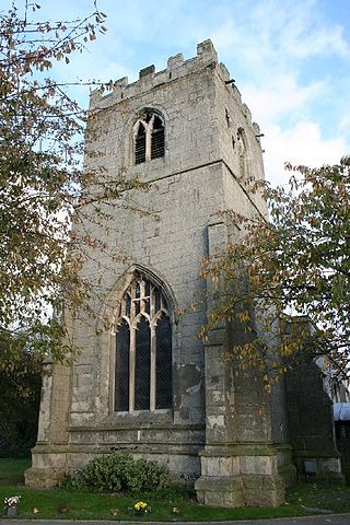
South Wheatley is a village and former civil parish, now within the North and South Wheatley civil parish, of Bassetlaw district, in the county of Nottinghamshire, England. In 2001 South Wheatley parish had a population of 102. It is 130 miles north of London, 30 miles north east of the county town of Nottingham, and 5 miles north east of the Nottinghamshire town of Retford. There are 4 listed buildings in South Wheatley.

<span class="mw-page-title-main">North and South Wheatley</span> Civil parish in Nottinghamshire, England

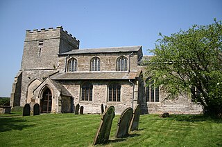
North and South Wheatley is a civil parish in the Bassetlaw district, in the county of Nottinghamshire, England. The parish includes the villages of North Wheatley and South Wheatley. In 2011 North Wheatley parish had a population of 509. It is 130 miles north of London, 30 miles north east of the county town of Nottingham, and 5 miles north east of the Nottinghamshire town of Retford. The parish touches Bole, Clarborough and Welham, Clayworth, Hayton, Saundby, Sturton Le Steeple and West Burton. There are 18 listed buildings in North and South Wheatley.

<span class="mw-page-title-main">Newington, Nottinghamshire</span> Hamlet in Nottinghamshire, England

Newington is a hamlet in the Bassetlaw district of northern Nottinghamshire, England. It is 138 miles (222 km) north west of London, 34 miles (55 km) north of the county town and city of Nottingham, and 1 mile (1.6 km) north east of the nearest town Bawtry. It is in the civil parish of Misson.

Scaftworth is a civil parish in the Bassetlaw District of Nottinghamshire, England. The parish contains three listed buildings that are recorded in the National Heritage List for England. All the listed buildings are designated at Grade II, the lowest of the three grades, which is applied to "buildings of national importance and special interest". The parish contains the hamlet of Scaftworth and the surrounding countryside, and the listed buildings consist of a house, a barn and a road bridge.

References

  1. Retford Times Friday 13 August 1982, page 6
  2. "Farm Of The Week: River that's causing flood of problems". www.yorkshirepost.co.uk. Retrieved 12 November 2020.
  3. UK Census (2021). "2021 Census Area Profile – Scaftworth parish (E04007834)". Nomis. Office for National Statistics . Retrieved 12 January 2024.
  4. "History of Scaftworth, in Bassetlaw and Nottinghamshire | Map and description". www.visionofbritain.org.uk. Retrieved 11 November 2020.
  5. "Scaftworth conservation area" (PDF).
  6. "Key to English Place-names". kepn.nottingham.ac.uk. Retrieved 11 November 2020.
  7. "Scaftworth :: Survey of English Place-Names". epns.nottingham.ac.uk. Retrieved 13 November 2020.
  8. 1 2 "Everton, Scaftworth, Harwell". www.british-history.ac.uk. Retrieved 11 November 2020.
  9. "Scaftworth". opendomesday.org. Retrieved 13 November 2020.
  10. "Network changes - 1930s - Roader's Digest: The SABRE Wiki". www.sabre-roads.org.uk. Retrieved 11 November 2020.
  11. Historic England. "Bawtry Bridge, Bawtry (1239428)". National Heritage List for England . Retrieved 12 November 2020.
  12. "The North Yorkshire, South Yorkshire and Nottinghamshire (County Boundaries) Order 1991".
  13. "David Heys steam diesel photo collection - 80 - BR North-East Railmen 5". David Heys collection. Retrieved 12 November 2020.
  14. "[PDF] A guide to family and estate archives held at the Northamptonshire Record Office Samwell to Strong - Free Download PDF". silo.tips. Retrieved 13 November 2020.
  15. "John Chapman's Map of Nottinghamshire 1774". Chapman et al. 27 August 2015. Retrieved 12 November 2020.
  16. "Genuki: White's Directory of Nottinghamshire, 1853, Nottinghamshire". www.genuki.org.uk. Retrieved 12 November 2020.
  17. "28a Lincoln to Doncaster". roadsofromanbritain.org. Retrieved 12 November 2020.
  18. 1 2 Historic England. "Roman fort and a section of Roman road 350m north west of Holly House Farm, Scaftworth (1018529)". National Heritage List for England . Retrieved 12 November 2020.
  19. Feeley, Mark (17 September 2020). "The Mystery of Morbio - Scaftworth Revisited". Roman Fables. Retrieved 12 November 2020.
  20. Historic England. "Kersall Lodge Farmhouse, Kersall (1370135)". National Heritage List for England . Retrieved 11 November 2020.
  21. Historic England. "Bawtry Bridge, Bawtry (1314826)". National Heritage List for England . Retrieved 12 November 2020.