Sekgakgapeng

Last updated

Sekgakgapeng
South Africa Limpopo location map.svg
Red pog.svg
Sekgakgapeng
South Africa adm location map.svg
Red pog.svg
Sekgakgapeng
Coordinates: 24°06′40″S29°02′46″E / 24.111°S 29.046°E
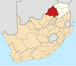
 / -24.111; 29.046
Country South Africa
Province Limpopo
District Waterberg
Municipality Mogalakwena
Area
[1]
  Total4.64 km2 (1.79 sq mi)
Population
 (2011) [1]
  Total11,979
  Density2,600/km2 (6,700/sq mi)
Racial makeup (2011)
[1]
   Black African 99.5%
   Coloured 0.1%
   Indian/Asian 0.2%
  Other0.1%
First languages (2011)
[1]
   Northern Sotho 65.4%
   S. Ndebele 21.8%
   Sotho 6.2%
   Tsonga 1.5%
  Other5.2%
Time zone UTC+2 (SAST)
PO box
0651
Area code 015

About the area

Sekgakgapeng is a large, semi-urban rural township located just north of Mokopane on the N11 road in the Waterberg district of the Limpopo province of South Africa.

Contents

The settlement has grown to increasingly encroach into the town of Mokopane, previously known as Potgietersrus. Therefore, the settlement of Sekgakgapeng provides a convenient residential location to those seeking work opportunities in the nearby Mokopane and Mahwelereng.

Education

The following schools are located in Sekgakgapeng:

Primary schools: Sokgedlwa Primary School; Mageme Primary School; and Madiphatlo Primary School.

High schools: Nkakabidi Secondary School; and Gwenane Secondary School.

Notable people

Notable people from Sekgakgapeng include:

Matshela Koko - Former CEO of Eskom [2]

Features

Notable features in Sekgakgapeng include:

A mountain painted with the word Jesus

River of Mogalakwena, used as a fishing spot by locals.

Entertainment zone and night club called Apollong.

Service delivery

Sekgakgapeng has long suffered from service delivery backlogs, including roads, water, sanitation, and waste management. Lack of opportunities in the area has led to social ills that include teenage drug abuse, house breaking, and other forms of criminal deviant behaviours.

Notable progress include electrification programmes and water reticulation. A new clinic called Manyonga Clinic was opened in 2019 1

The private sector has invested some retail facilities in the area, for example Shoprite, further easing the cost of traveling to the nearby town. But this has had a negative impact on small retailers in the area. Mining companies have taken interest in the area. Ivanplats, a platinum mining company, supports science and technology related initiatives in schools 2 .

The use of animal drawn carts, mainly donkeys, remains prevalent in the area. The donkey carts are used to collect and deliver groceries for the locals. The flat terrain makes Sekgakgapeng easy for this form of transport and cycling.

Related Research Articles

<span class="mw-page-title-main">Stawell, Victoria</span> Town in Victoria, Australia

Stawell ( "stall"), is an Australian town in the Wimmera region of Victoria 237 kilometres (147 mi) west-north-west of the state capital, Melbourne. Located within the Shire of Northern Grampians local government area, it is a seat of local government for the shire and its main administrative centre. At the 2021 census, Stawell had a population of 6,220.

<span class="mw-page-title-main">Methil</span> Human settlement in Scotland

Methil is an eastern coastal town in Scotland. It was first recorded as "Methkil" in 1207, and belonged to the Bishop of St Andrews. Two Bronze Age cemeteries have been discovered which date the settlement as over 8,000 years old. Famous for its High Street that used to have the most pubs per mile in Scotland, it was part of its own barony in 1614 and also part of the former burgh of Buckhaven and Methil. This burgh existed between 1891 and 1975. It is situated within a continuous urban area described as Levenmouth.

<span class="mw-page-title-main">Totton and Eling</span> Human settlement in England

Totton and Eling is a civil parish in Hampshire, England, with a population of about 28,100 people. It contains the town of Totton and is situated between the eastern edge of the New Forest and the River Test, close to the city of Southampton but outside the city boundary; the town is within the New Forest non-metropolitan district. Surrounding towns and villages include Ashurst, Marchwood, Cadnam and Ower.

<span class="mw-page-title-main">Pearcedale, Victoria</span> Town in Victoria, Australia

Pearcedale is a township and coastal rural locality in Victoria, Australia, 49 km south-east of Melbourne's Central Business District, located within the City of Casey and the Shire of Mornington Peninsula local government areas. Pearcedale recorded a population of 3,867 at the 2021 census.

<span class="mw-page-title-main">Inchinnan</span> Human settlement in Scotland

Inchinnan is a small village in Renfrewshire, Scotland. The village is located on the main A8 road between Renfrew and Greenock, just south east of the town of Erskine.

<span class="mw-page-title-main">Welkom</span> City in Free State, South Africa

Welkom is the second-largest city in the Free State province of South Africa, located about 140 kilometres (90 mi) northeast of Bloemfontein, the provincial capital. Welkom is also known as Circle City, City Within A Garden, Mvela and Matjhabeng. The city's Sesotho name, Matjhabeng means 'where nations meet', derived from the migrant labour system, where people of various countries such as Lesotho, Malawi and Mozambique etc. met to work in the mines of the gold fields.

Lephalale, formerly known as Ellisras, is a coal mining town in the Limpopo province of South Africa immediately east of the Waterberg Coalfield. The town was established as Ellisras in 1960 and named after Patrick Ellis and Piet Erasmus who settled on a farm there in the 1930s. In 2002, Ellisras was renamed Lephalale by the provincial government of Limpopo, after the main river that crosses the municipality. Lephalale is derived from the setswana language meaning "to flow".

<span class="mw-page-title-main">Mokopane</span> Place in Limpopo, South Africa

Mokopane, formerly known as Potgietersrus, is a town in the Limpopo province of South Africa.

Couva is an urban town in west-central Trinidad, south of Port of Spain and Chaguanas and north of San Fernando and Point Fortin. It is the capital and main urban centre of Couva–Tabaquite–Talparo, and the Greater Couva area includes the Point Lisas industrial estate and the port of Point Lisas. It is one of the fastest-growing towns in the country. Couva's southern boundary is at the village of California and Point Lisas, and to the north Couva stretches to McBean. To the east of Couva is Preysal. To the west of Couva is the road to Waterloo and Carli Bay, which are located on the Gulf of Paria. Couva was part of the Caroni County. Couva is considered a major power base for the United National Congress, whose headquarters was previously located here.

<span class="mw-page-title-main">Francistown</span> City in North-East District, Botswana

Francistown is the second-largest city in Botswana, with a population of about 103,417 and 147,122 inhabitants for its agglomeration at the 2022 census. It is located in eastern Botswana, about 400 kilometres (250 mi) north-northeast from the capital, Gaborone. Francistown is located at the confluence of the Tati and Ntshe rivers, and near the Shashe River and 90 kilometres (56 mi) from the international border with Zimbabwe.

<span class="mw-page-title-main">Victoria Falls, Zimbabwe</span> Resort City in Matabeleland North, Zimbabwe

Victoria Falls, popularly known as Vic Falls, is a resort town and city in the province of Matabeleland North, Zimbabwe. It lies on the southern bank of the Zambezi River at the western end of Victoria Falls themselves. According to the 2022 Population Census, the town had a population of 35,199.

Shurugwi, originally known as Selukwe, is a small town and administrative centre in Midlands Province, southern Zimbabwe, located about 350 km south of Harare, with a population of 22,900 according to the 2022 census. The town was established in 1899 on the Selukwe Goldfield, which itself was discovered in the early 1890s not long after the annexation of Rhodesia by the Pioneer Column.

<span class="mw-page-title-main">Khayelitsha</span> Suburb of Cape Town, in Western Cape, South Africa

Khayelitsha is a township in Western Cape, South Africa, on the Cape Flats in the City of Cape Town Metropolitan Municipality. The name is Xhosa for New Home. It is reputed to be one of the largest and fastest-growing townships in South Africa.

Chatsworth is a small settlement in the Masvingo Province of Zimbabwe. It is located about 58 km north of Masvingo on the Masvingo-Gweru railway line. The settlement started in 1911 as a railway station. It administered under the Gutu Rural District Council.

<span class="mw-page-title-main">Lupane District</span> Administrative district in Matabeleland North, Zimbabwe

Lupane ( luːpɑːnɛ) District is located in the Matabeleland North Province of Zimbabwe, and it is also the Provincial Capital. The District is situated at an elevation of 976 m with a population of 107,000 inhabitants by 2022. Lupane Town is the main center of the district located 172 km from Bulawayo along the A8 Victoria Falls Road. The Government Provincial Administrative offices are located at the Town Centre. A new university near the Town has been established under the name Lupane State University, which caters for the region and beyond. The word Lupane is thought to be a Kalanga or Lozwi word.

Mahwelereng is a township in the Mogalakwena Local Municipality of the Waterberg District Municipality of the Limpopo Province of South Africa, It is about 2 km from Mokopane. The township is a product of Apartheid South Africa's policies in the former Bantustan of Lebowa. Most of the original residents of Mahwelereng were from an area which old residents call "Ol' Location". Ol' Location was too close to town and the residents had to be moved further away from town. There are still remnants of Ol' Location such as the "Bar" and the Lutheran Church Mission on the Sekgakgapeng site. The township is bordered by Sekgakgapeng, Mountainview, Moshate, Phola Park, and Ga-Madiba.

<span class="mw-page-title-main">Mwenezi District</span> District in Masvingo, Zimbabwe

Mwenezi, originally known as Nuanetsi, is a small district situated in southern Zimbabwe. It is bisected by the Mwenezi River and the A4 highway, the main thoroughfare that connects the town of Beitbridge, on the border with South Africa, to Masvingo.

Phoenix is a South African town about 25 kilometres (15 mi) northwest of Durban Central, in KwaZulu-Natal, South Africa. It was established as a town by the apartheid government in 1976, but it has a long history of Indian occupation. It is associated with the Phoenix Settlement, built by Mahatma Gandhi.

<span class="mw-page-title-main">Rietoog</span> Settlement in the Hardap region of Namibia

Rietoog is a settlement in the Hardap Region of Namibia. It is situated 112 kilometres (70 mi) southwest of Rehoboth and 130 kilometres (81 mi) north of Maltahöhe along the M47 gravel road and belongs to the Rehoboth Rural electoral constituency. The name Rietoog means Cane-eye in Afrikaans, named after a spring that looks like an eye, surrounded by canes, near the town.

Masehlaneng is a village situated northwest of the town of Mokopane in the Waterberg District of the Limpopo province of South Africa. It is about 8 km from Mokopane, which is two hours from Gauteng by road. The population is multiethnic. The dominant languages in the area are Northern Sotho and Northern Ndebele.

References

  1. 1 2 3 4 "Main Place Sekgakgapeng". Census 2011. Archived from the original on 26 April 2023. Retrieved 25 March 2019.
  2. "Engineer Matšhela Koko, MBL". Twitter. Archived from the original on 27 October 2022. Retrieved 27 October 2022.