
Bernwood Forest is a forest in England. Historically it was one of several forests of the ancient Kingdom of England and was a Royal hunting forest. It is thought to have been set aside as Royal hunting land when the Anglo-Saxon kings had a palace at Brill and church in Oakley, in the 10th century and was a particularly favoured place of Edward the Confessor, who was born in nearby Islip.

The Berkshire, Buckinghamshire and Oxfordshire Wildlife Trust (BBOWT), is a Wildlife Trust covering the counties of Berkshire, Buckinghamshire and Oxfordshire in England.

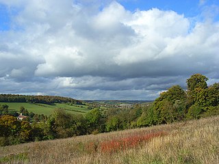
Hartslock, also known as Hartslock Woods, is a 41.8-hectare (103-acre) biological Site of Special Scientific Interest (SSSI) in a wooded area on the north bank of the River Thames to the south-east of Goring-on-Thames in the English county of Oxfordshire. An area of 29.4 hectares is a Special Area of Conservation and an area of 10 hectares is a nature reserve owned and managed by the Berkshire, Buckinghamshire and Oxfordshire Wildlife Trust (BBOWT). The site is well known for the variety of wild orchids that grow on its sloping grassland, and especially for the monkey orchid that grows in very few other places in England.

Moor Copse is a 65-hectare (160-acre) nature reserve west of Reading in Berkshire. It is managed by the Berkshire, Buckinghamshire and Oxfordshire Wildlife Trust. Parts of it are in Sulham and Tidmarsh Woods and Meadows, which is a Site of Special Scientific Interest.

Broadmoor to Bagshot Woods and Heaths is a 1,696.3-hectare (4,192-acre) biological Site of Special Scientific Interest (SSSI) in Berkshire and Surrey that extend from a minority of the parish of Crowthorne including around Broadmoor Hospital in the west to Bagshot south-east, Bracknell north-east, and Sandhurst, south. It is part of the Thames Basin Heaths Special Protection Area. Two nature reserves which are managed by the Surrey Wildlife Trust are in the SSSI, Barossa nature reserve and Poors Allotment. Broadmoor Bottom, which is part of Wildmoor Heath, also falls within the SSSI; this reserve is managed by the Berkshire, Buckinghamshire and Oxfordshire Wildlife Trust.

Bowdown and Chamberhouse Woods is a 67.9-hectare (168-acre) biological Site of Special Scientific Interest south of Thatcham in Berkshire. An area of 55 hectares is a nature reserve managed by the Berkshire, Buckinghamshire and Oxfordshire Wildlife Trust.
Sulham and Tidmarsh Woods and Meadows is a 75.7-hectare (187-acre) biological Site of Special Scientific Interest west of Reading in Berkshire. Previously known as Pang Valley SSSI, the site is mostly sandwiched between the River Pang and the Sulham Road and includes Broom Copse, Herridge's Copse, Hogmoor Copse, Park Wood, Moor Copse and Barton's Copse. Much of the southern part of the site is the Berkshire, Buckinghamshire and Oxfordshire Wildlife Trust's Moor Copse Nature Reserve. The whole site lies within the North Wessex Downs Area of Outstanding Natural Beauty.

Bucklebury Common is an elevated common consisting of woodland with a few relatively small clearings in the English county of Berkshire, within the civil parish of Bucklebury centred 3 miles (4.8 km) northeast of Thatcham and encircling the settled localities of Upper Bucklebury and Chapel Row. It is one of the largest commons in Southern England covering 350 hectares. Since Inclosure the area is privately owned by the Bucklebury Manor estate, but has public access on a network of public rights of way bolstered by the Countryside and Rights of Way Act 2000.

Foxcote Reservoir and Wood is a 48.3-hectare (119-acre) biological Site of Special Scientific Interest between Akeley and Maids Moreton in Buckinghamshire, England. An area of 34 hectares is managed by the Berkshire, Buckinghamshire and Oxfordshire Wildlife Trust.

Hollowhill and Pullingshill Woods is a 23-hectare biological Site of Special Scientific Interest near Marlow in Buckinghamshire. It is in the Chilterns Area of Outstanding Natural Beauty, and the Chilterns Beechwoods Special Area of Conservation. The local planning authorities are Wycombe District Council and Buckinghamshire County Council. Pullingshill Wood is owned by the Woodland Trust, and Hollowhill Wood was formerly owned by Buckinghamshire County Council, but was transferred to the Berkshire, Buckinghamshire and Oxfordshire Wildlife Trust. Since November 2015 the 7.8-hectare site has been managed by the Trust as "Hog and Hollowhill Woods".

Homefield Wood is a 6.1-hectare (15-acre) Site of Special Scientific Interest in Hambleden in Buckinghamshire. It is owned by the Forestry Commission, and managed by the Berkshire, Buckinghamshire and Oxfordshire Wildlife Trust. It is part of the Chilterns Area of Outstanding Natural Beauty.

Dancersend is an 81.3-hectare (201-acre) Site of Special Scientific Interest (SSSI) south of Aston Clinton in Buckinghamshire. Part of the site is managed by the Forestry Commission and part by the Berkshire, Buckinghamshire and Oxfordshire Wildlife Trust (BBOWT). The BBOWT's 47 hectare nature reserve, called Dancersend with Pavis Woods, extends into fields west of the SSSI. It is in the Chilterns Areas of Outstanding Natural Beauty.
Millfield Wood is a 9.5-hectare (23-acre) biological Site of Special Scientific Interest north of High Wycombe in Buckinghamshire. It is owned and managed by the Berkshire, Buckinghamshire and Oxfordshire Wildlife Trust, and it is in the Chilterns Areas of Outstanding Natural Beauty.

Swain's Wood is a 16.2-hectare (40-acre) biological Site of Special Scientific Interest west of Turville in Buckinghamshire. It is in the Chilterns Area of Outstanding Natural Beauty, and is managed by the Berkshire, Buckinghamshire and Oxfordshire Wildlife Trust.

Long Herdon Meadow is a 4.5-hectare (11-acre) biological Site of Special Scientific Interest south of Marsh Gibbon in Buckinghamshire. It is part of Upper Ray Meadows nature reserve, which is managed by the Berkshire, Buckinghamshire and Oxfordshire Wildlife Trust.

Upper Ray Meadows is a 181-hectare nature reserve, managed by the Berkshire, Buckinghamshire and Oxfordshire Wildlife Trust, south of Marsh Gibbon in Buckinghamshire. It is composed of a number of areas, one of which, Long Herdon Meadow, is a biological Site of Special Scientific Interest.

Chawridge Bourne is a 9.4-hectare (23-acre) biological Site of Special Scientific Interest in Berkshire, England Part of the site is a 5-hectare (12-acre) nature reserve called Chawridge Bank, which is managed by the Berkshire, Buckinghamshire and Oxfordshire Wildlife Trust.
Whitecross Green and Oriel Woods is a 63-hectare (160-acre) biological Site of Special Scientific Interest between Oxford and Bicester in Oxfordshire. It is owned and managed by the Berkshire, Buckinghamshire and Oxfordshire Wildlife Trust under the name Whitecross Green Wood.

Bould Wood is a 58.2-hectare (144-acre) biological Site of Special Scientific Interest north of Shipton-under-Wychwood in Oxfordshire. An area of 23 hectares is Foxholes nature reserve, which is managed by the Berkshire, Buckinghamshire and Oxfordshire Wildlife Trust.
