Taplow is a village and civil parish in the Unitary Authority of Buckinghamshire, England. It sits on the left bank of the River Thames, facing Maidenhead in the neighbouring county of Berkshire, with Cippenham and Burnham to the east. It is the south-westernmost settlement in Buckinghamshire.

Aston Rowant Cutting is a 3.5-hectare (8.6-acre) geological Site of Special Scientific Interest south of Aston Rowant in Oxfordshire. It is a Geological Conservation Review site.

Boxford Chalk Pit is a 0.4-hectare (0.99-acre) geological Site of Special Scientific Interest in Boxford in Berkshire. It is a Geological Conservation Review site.
Southerham Works Pit is a 1-hectare (2.5-acre) geological Site of Special Scientific Interest in Lewes in East Sussex. It is a Geological Conservation Review site.

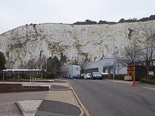
Kensworth Chalk Quarry is a 131.3-hectare (324-acre) geological Site of Special Scientific Interest in Kensworth in Bedfordshire. It was notified under Section 28 of the Wildlife and Countryside Act 1981, and the local planning authority is Central Bedfordshire.

Dancersend is an 81.3-hectare (201-acre) Site of Special Scientific Interest (SSSI) south of Aston Clinton in Buckinghamshire. Part of the site is managed by the Forestry Commission and part by the Berkshire, Buckinghamshire and Oxfordshire Wildlife Trust (BBOWT). The BBOWT's 47 hectare nature reserve, called Dancersend with Pavis Woods, extends into fields west of the SSSI. It is in the Chilterns Areas of Outstanding Natural Beauty.
Stone SSSI is a 0.12-hectare (0.30-acre) geological Site of Special Scientific Interest in Stone in Buckinghamshire. It is listed by the Joint Nature Conservation Committee as a Geological Conservation Review site.
Bugle Quarry is a 0.08-hectare (0.20-acre) geological Site of Special Scientific Interest in Hartwell in Buckinghamshire. The local planning authority is Aylesbury Vale District Council. It has two entries in the Geological Conservation Review of the Joint Nature Conservation Committee.

Bolter End Sand Pit is a 0.33-hectare (0.82-acre) geological Site of Special Scientific Interest at Bolter End Common in Buckinghamshire.

Fern House Gravel Pit is a 1.3-hectare (3.2-acre) geological Site of Special Scientific Interest in Fern, near Bourne End in Buckinghamshire. It is also a Geological Conservation Review site.

Purfleet Chalk Pits is a 10.7-hectare (26-acre) geological Site of Special Scientific Interest in Purfleet in Essex. It is a Geological Conservation Review site.

Barrington Chalk Pit is a 97.1-hectare (240-acre) geological Site of Special Scientific Interest near Barrington in Cambridgeshire. It is a Geological Conservation Review site.

Winterbourne Chalk Pit is a 0.05-hectare (0.12-acre) geological Site of Special Scientific Interest west of Winterbourne in Berkshire. It is a Geological Conservation Review site. It is located within the North Wessex Downs.

Chinnor Chalk Pit is a 20.4-hectare (50-acre) geological Site of Special Scientific Interest south of Chinnor in Oxfordshire. It is a Geological Conservation Review site.

Duncroft Farm Pit is a 0.1-hectare (0.25-acre) geological Site of Special Scientific Interest west of Kingsclere in Hampshire. It is a Geological Conservation Review site.
