Bacombe and Coombe Hills

Last updated

Bacombe and Coombe Hills
Site of Special Scientific Interest
Ridgeway on Bacombe Hill - geograph.org.uk - 580111.jpg
Ridgeway on Bacombe Hill
Location Buckinghamshire
Grid reference SP852068
InterestBiological
Area76.4 hectares
Notification 1999
Location map Magic Map

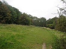
Bacombe and Coombe Hills is a 76.4-hectare (189-acre) biological Site of Special Scientific Interest in Upper Bacombe in Buckinghamshire. [1] [2] Bacombe Hill was formerly owned by Buckinghamshire County Council, which transferred it to Berkshire, Buckinghamshire and Oxfordshire Wildlife Trust in 2014. [3] [4] Coombe Hill is owned by the National Trust. [5]

The site is in the Chilterns Area of Outstanding Natural Beauty [6] and Bacombe Hill is a Local Nature Reserve. [7] [8] The Ridgeway National Trail crosses the site. [6]

The site is chalk grassland which has a rich variety of species. including the entire British population of fringed gentian, and there are areas of juniper and mixed scrub. Invertebrates include scarce species, such as chalkhill blue and brown argus butterflies. [1] Bacombe Hill is noted for orchids. [7]

There is access from Ellesbrough Road. [6]

Related Research Articles

<span class="mw-page-title-main">Upper and Lower Bacombe</span>

Upper Bacombe and Lower Bacombe are two hamlets in the parish of Wendover, in Buckinghamshire, England. They are located to the south east of the main town, on and at the foot of Bacombe Hill, which is a Local Nature Reserve, and part of the Bacombe and Coombe Hills Site of Special Scientific Interest.

<span class="mw-page-title-main">Berkshire, Buckinghamshire and Oxfordshire Wildlife Trust</span> Wildlife conservation charity

The Berkshire, Buckinghamshire and Oxfordshire Wildlife Trust (BBOWT), is a wildlife trust covering the counties of Berkshire, Buckinghamshire and Oxfordshire in England.

<span class="mw-page-title-main">Windsor Hill</span> Biological Site

Windsor Hill is a 61.8 hectare biological Site of Special Scientific Interest in Princes Risborough in Buckinghamshire. It lies within the Chilterns Area of Outstanding Natural Beauty, and it is featured in the Nature Conservation Review. A small part is managed by the Berkshire, Buckinghamshire and Oxfordshire Wildlife Trust, and access to this area requires a permit.

<span class="mw-page-title-main">Chimney Meadows</span>

Chimney Meadows is a 49.6-hectare (123-acre) biological Site of Special Scientific Interest between Abingdon-on-Thames and Faringdon in Oxfordshire. It is also a national nature reserve, and part of the 308-hectare (760-acre) Chimney Meadows nature reserve, which is managed by the Berkshire, Buckinghamshire and Oxfordshire Wildlife Trust.

<span class="mw-page-title-main">Gomm Valley</span>

Gomm Valley is a 4.1-hectare (10-acre) biological Site of Special Scientific Interest in Micklefield, a district of High Wycombe in Buckinghamshire. It is managed by the Berkshire, Buckinghamshire and Oxfordshire Wildlife Trust and is part of the Chilterns Area of Outstanding Natural Beauty. The local planning authority is Wycombe District Council.

<span class="mw-page-title-main">Grangelands and Pulpit Hill</span>

Grangelands and Pulpit Hill is a 25.5-hectare (63-acre) biological Site of Special Scientific Interest in Cadsden in Buckinghamshire. It lies within the Chilterns Area of Outstanding Natural Beauty, and the planning authorities are Wycombe District Council and Buckinghamshire County Council.

<span class="mw-page-title-main">Hollowhill and Pullingshill Woods</span>

Hollowhill and Pullingshill Woods is a 23-hectare biological Site of Special Scientific Interest near Marlow in Buckinghamshire. It is in the Chilterns Area of Outstanding Natural Beauty, and the Chilterns Beechwoods Special Area of Conservation. The local planning authorities are Wycombe District Council and Buckinghamshire County Council. Pullingshill Wood is owned by the Woodland Trust, and Hollowhill Wood was formerly owned by Buckinghamshire County Council, but was transferred to the Berkshire, Buckinghamshire and Oxfordshire Wildlife Trust. Since November 2015 the 7.8-hectare site has been managed by the Trust as "Hog and Hollowhill Woods".

<span class="mw-page-title-main">Homefield Wood</span>

Homefield Wood is a 6.1 hectare Site of Special Scientific Interest in Hambleden in Buckinghamshire. It is owned by the Forestry Commission, and managed by the Berkshire, Buckinghamshire and Oxfordshire Wildlife Trust. It is part of the Chilterns Area of Outstanding Natural Beauty.

<span class="mw-page-title-main">College Lake nature reserve</span>

College Lake is a 65 hectare nature reserve in a former chalk quarry in Pitstone in the Aylesbury Vale district of Buckinghamshire. It is one of the flagship reserves of the Berkshire, Buckinghamshire and Oxfordshire Wildlife Trust, and it has an information centre, education facilities, a café, toilets and a shop. It is in the Chilterns Area of Outstanding Natural Beauty. The area east of the lake is a geological Site of Special Scientific Interest called Pitstone Quarry.

<span class="mw-page-title-main">Aston Clinton Ragpits</span>

Aston Clinton Ragpits is a 2.9-hectare (7.2-acre) biological Site of Special Scientific Interest in Aston Clinton in Buckinghamshire. It is a former chalk quarry, which is now a nature reserve managed by the Berkshire, Buckinghamshire and Oxfordshire Wildlife Trust. It is in the Chilterns Area of Outstanding Natural Beauty.

<span class="mw-page-title-main">Dancersend</span>

Dancersend is an 81.3 hectare Site of Special Scientific Interest (SSSI) south of Aston Clinton in Buckinghamshire. Part of the site is managed by the Forestry Commission and part by the Berkshire, Buckinghamshire and Oxfordshire Wildlife Trust (BBOWT). The BBOWT's 47 hectare nature reserve, called Dancersend with Pavis Woods, extends into fields west of the SSSI. It is in the Chilterns Areas of Outstanding Natural Beauty.

<span class="mw-page-title-main">Millfield Wood</span>

Millfield Wood is a 9.5-hectare (23-acre) biological Site of Special Scientific Interest north of High Wycombe in Buckinghamshire. It is owned and managed by the Berkshire, Buckinghamshire and Oxfordshire Wildlife Trust, and it is in the Chilterns Areas of Outstanding Natural Beauty.

<span class="mw-page-title-main">Swain's Wood</span>

Swain's Wood is a 16.2 hectare biological Site of Special Scientific Interest west of Turville in Buckinghamshire. It is in the Chilterns Area of Outstanding Natural Beauty, and is managed by the Berkshire, Buckinghamshire and Oxfordshire Wildlife Trust.

<span class="mw-page-title-main">Rushbeds Wood</span> Nature reserve in Ireland

Rushbeds Wood is a 56-hectare (140-acre) nature reserve near Wotton Underwood in Buckinghamshire, managed by the Berkshire, Buckinghamshire and Oxfordshire Wildlife Trust (BBOWT). It is a surviving fragment of the ancient Bernwood Forest. The reserve is part of Rushbeds Wood and Railway Cutting, an 80.2-hectare (198-acre) biological Site of Special Scientific Interest. This includes a section of the Chiltern Main Line railway cutting, which runs along the north-east side of the BBOWT reserve.

References

  1. 1 2 "Bacombe and Coombe Hills citation" (PDF). Sites of Special Scientific Interest. Natural England. Archived from the original (PDF) on 31 December 2014. Retrieved 4 January 2015.
  2. "Map of Bacombe and Coombe Hills". Sites of Special Scientific Interest. Natural England. Retrieved 4 January 2015.
  3. "Officer Executive Decision - Divestment of land at Bacombe Hill to Berkshire, Buckinghamshire & Oxfordshire Wildlife Trust" (PDF). Buckinghamshire County Council. 5 October 2014.
  4. "COMMUNITY WILDLIFE OFFICER (BUCKS)" (PDF). Berkshire, Buckinghamshire & Oxfordshire Wildlife Trust. Archived from the original (PDF) on 29 September 2015. Retrieved 28 September 2015.
  5. "Chilterns Countryside". National Trust. Retrieved 28 September 2015.
  6. 1 2 3 "Bacombe Hill Local Nature Reserve". Chilterns Conservation Board. Retrieved 4 January 2015.
  7. 1 2 "Bacombe Hill". Local Nature Reserves. Natural England. 8 August 2013. Archived from the original on 4 January 2015. Retrieved 4 January 2015.
  8. "Map of Bacombe Hill". Local Nature Reserves. Natural England. Retrieved 4 January 2015.

Coordinates: 51°45′12″N0°46′02″W / 51.7534°N 0.7671°W / 51.7534; -0.7671