Shadwell Basin is a housing and leisure complex built around a disused dock in Wapping, London. The old dock was formerly part of the London Docks, a group of docks built by the London Dock Company at Shadwell and Wapping as part of the wider docks of the Port of London.
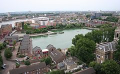
Today Shadwell Basin is one of the most significant bodies of water surviving from the historical London Docks. It is situated on the north side of the river Thames east (downstream) of the Tower of London and Tower Bridge and west (upstream) of Limehouse.
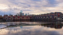
Unlike some of the London Docks which have been landfilled, Shadwell Basin, the most easterly part of the complex, has been retained. It is now a maritime square of 2.8 hectares used for recreational purposes (including sailing, canoeing and fishing) and is surrounded on three sides by a waterside housing development designed by British architects MacCormac, Jamieson, Prichard and Wright (MJPW) and constructed 1986–1988.[1]
The residential buildings are four and five storeys with façades of alternating open arches and enclosed structure, echoing the scale of traditional 19th century dockside warehouses, with a colonnade at quayside. It took inspiration from the Royal Albert Dock in Liverpool.[1] The development, made up of buildings on Newlands Quay, Maynards Quay and Peartree Lane, was added to the National Heritage List for England by Historic England as Grade II listed in 2018, part of a listing of postmodern buildings.[1][2]
Shadwell Basin has Benson Quay on its south-west corner with its south side overlooked by Riverside Mansions in Milk Yard and the Monza Building in Monza Street and, at its south-eastern end, the former Wapping Hydraulic Power Station building.
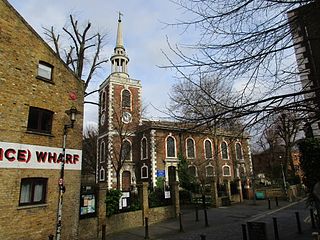
On the north side of Shadwell Basin, east of Newlands Quay, St Paul's Church provides a dramatic backdrop with its spire and the St Paul's Church Conservation Area extends to the water's edge with a terraced quayside that includes an outdoor gym.
Shadwell Basin is a popular public route for cyclists, joggers and pedestrians with a walkway alongside the water as part of the linked open spaces and canals between the river and Hermitage Basin near St Katharine Docks to the west.
History
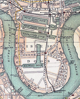
The London Docks expanded eastward in the 1830s with the opening of the Eastern Dock and Shadwell Basin (built 1828–32). To provide these new docks with access to the river, a new entrance at Shadwell was built. Opened in 1832, it was named Shadwell Entrance (the main entrance to the London Dock was through Wapping Entrance with a third entrance at Hermitage Basin).
Part of the Shadwell Basin Housing built in the 1980s and now Grade II listed
By the 1850s, the London Dock Company had recognised that the entrances at both Wapping and Shadwell were too small to accommodate the newer and larger ships coming into service. In 1854-58 the company built a new larger entrance (45 feet wide) and a new basin at Shadwell (the only element of the London Docks system to have survived redevelopment to this day) linked to the west part of the docks by Eastern Dock and the short Tobacco Dock.
The small size of the London Docks made them outdated by the early 20th century as steam power meant ships were built too large to fit into them. Cargoes were unloaded downriver and then ferried by barge to warehouses in Wapping. This system was uneconomic and inefficient and one of the main reasons that London's western docks (St Katharine Dock and the London Docks) were the first to close in the 1960s.
The London Docks complex closed to shipping in 1969. Purchased by the London Borough of Tower Hamlets, Shadwell Basin and the western part of the London Docks fell into a derelict state,[4] mostly a large open tract of land and water. Acquired in 1981 by the London Docklands Development Corporation (LDDC), redevelopment of Shadwell Basin took place in 1987 resulting in 169 houses and flats being built around the retained historic dock.
Jane Randolph Jefferson (1720–1776), mother of President of the United States Thomas Jefferson, was born in Shakespeare Walk (a road which ran from north to south in the middle of what is now Shadwell Basin) and was baptised at St. Paul's Church, Shadwell
London Docklands is the riverfront and former docks in London. It is located in inner east and southeast London, in the boroughs of Southwark, Tower Hamlets, Lewisham, Newham and Greenwich. The docks were formerly part of the Port of London, at one time the world's largest port. After the docks closed, the area had become derelict and poverty-ridden by the 1980s. The Docklands' regeneration began later that decade; it has been redeveloped principally for commercial and residential use. The name "London Docklands" was used for the first time in a government report on redevelopment plans in 1971 and has since been almost universally adopted. The redevelopment created wealth, but also led to some conflict between the new and old communities in the area.
Limehouse is a district in the London Borough of Tower Hamlets in East London. It is 3.9 miles (6.3 km) east of Charing Cross, on the northern bank of the River Thames. Its proximity to the river has given it a strong maritime character, which it retains through its riverside public houses and steps, such as The Grapes and Limehouse Stairs. It is part of the traditional county of Middlesex. It became part of the ceremonial County of London following the passing of the Local Government Act 1888, and then part of Greater London in 1965.
Rotherhithe is a district of South London, England, and part of the London Borough of Southwark. It is on a peninsula on the south bank of the Thames, facing Wapping, Shadwell and Limehouse on the north bank, with the Isle of Dogs to the east. It borders Bermondsey to the west and Deptford to the south-east. The district is a part of the Docklands area.
Wapping is an area in London, England and is located in the London Borough of Tower Hamlets. It is in East London and part of the East End. Wapping is on the north bank of the River Thames between St Katharine Docks to the west, and Shadwell to the east. This position gives the district a strong maritime character.
The London Borough of Tower Hamlets is a borough of London, England. Situated on the north bank of the River Thames and immediately east of the City of London, the borough spans much of the traditional East End of London and includes much of the regenerated London Docklands area. The 2019 mid-year population for the borough is estimated at 324,745.
St Katharine Docks is a former dock and now a mixed-used district in Central London, in the London Borough of Tower Hamlets and within the East End. It lies on the north bank of the River Thames, immediately downstream of the Tower of London and Tower Bridge. From 1828 to 1968, it was one of the commercial docks that made up the Port of London. It is in the redevelopment zone known as Docklands and is now a popular housing and leisure complex.
Shadwell is an area in London, England and is located in the London Borough of Tower Hamlets. It is in East London and part of the East End. Shadwell is on the north bank of the River Thames between Wapping and Ratcliff and Limehouse and is 3 miles (4.8 km) east of Charing Cross. This riverside location has meant the area's history and character have been shaped by the maritime trades.
The West India Docks are a series of three docks, quaysides, and warehouses built to import goods from, and export goods and occasionally passengers to the British West Indies. Located on the Isle of Dogs in London, the first dock opened in 1802. Following their commercial closure in 1980, the Canary Wharf development was built around the wet docks by narrowing some of their broadest tracts.
The London Docks were one of several sets of docks in the historic Port of London.
The Royal Victoria Dock is the largest of three docks in the Royal Docks of east London, now part of the redeveloped Docklands.
Salford Quays is an area of Salford, Greater Manchester, England, near the end of the Manchester Ship Canal. Previously the site of Manchester Docks, it faces Trafford across the canal.
Salthouse Dock is a dock on the River Mersey, England, and part of the Port of Liverpool. It is situated in the southern dock system, connected to Canning Dock to the north, Wapping Dock via Wapping Basin to the south and Albert Dock to the west.
Duke's Dock is a dock on the River Mersey, England, and part of the Port of Liverpool. It is in the southern dock system, connected to Salthouse Dock and Wapping Dock to the east. The Albert Dock is located immediately north, although not directly accessible by water.
Cable Street is a road in the East End of London, England, with several historic landmarks nearby. It was made famous by the Battle of Cable Street in 1936.
The Highway, part of which was formerly known as the Ratcliffe Highway, is a road in the London Borough of Tower Hamlets, in the East End of London. The route dates back to Roman times. In the 19th century it had a reputation for vice and crime and was the location of the Ratcliff Highway murders. Prior to a renaming programme of 1937, different parts of the route had different names depending on what district they were in.
St Paul's Church, Shadwell, is a Grade II* listed Church of England church, located between The Highway and Shadwell Basin, on the edge of Wapping, in the East End of London, England. The church has had varying fortunes over many centuries, and is now very active, having been supported recently by Holy Trinity Brompton Church.
The Grapes is a public house situated directly on the north bank of the Thames in London's Limehouse area, with a veranda overlooking the water. To its landward side, the pub is found at number 76 in Narrow Street, flanked by former warehouses now converted to residential and other uses. It is listed Grade II on the National Heritage List for England.
Silvertown Quays is a redevelopment scheme of 50 acres (20 ha) of former London docklands warehousing in the East London district of Silvertown. It is situated on the northside of the River Thames, the southside of the Royal Victoria Dock on the opposite quay to ExCeL exhibition centre, and immediately west of London City Airport.
St George in the East, historically known as Wapping-Stepney, was an ancient parish, in the London Borough of Tower Hamlets, England. The place name is no longer widely used.
This page is based on this Wikipedia article Text is available under the CC BY-SA 4.0 license; additional terms may apply. Images, videos and audio are available under their respective licenses.