Petticoat Lane Market

Last updated

Petticoat Lane Market:
Middlesex Street Market
and Wentworth Street Market
Petticoat Lane Market.jpg
The market in 2006
Location Spitalfields
London, E1
United Kingdom
Coordinates 51°31′0″N0°4′24″W / 51.51667°N 0.07333°W / 51.51667; -0.07333 Coordinates: 51°31′0″N0°4′24″W / 51.51667°N 0.07333°W / 51.51667; -0.07333
Management Tower Hamlets London Borough Council
OwnerTower Hamlets London Borough Council
EnvironmentOutdoor
Goods soldClothing, general goods
Days normally openSunday (Middlesex Street)
Sunday–Friday (Wentworth Street)
Number of tenants202 (Middlesex Street)
138 (Wentworth Street)

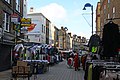
Petticoat Lane Market is a fashion and clothing market in Spitalfields, London. It consists of two adjacent street markets. Wentworth Street Market is open six days a week [1] and Middlesex Street Market is open on Sunday only. [2]

Contents

The modern market

It is one of a number of traditional markets located to the east of the City of London. A few hundred yards to the north is Old Spitalfields Market, which has been refurbished, and across Commercial Street, to the east, lies Brick Lane Market. A half mile further east is the Columbia Road Flower Market. Petticoat Lane Market was not formally recognised until an Act of Parliament in 1936,[ citation needed ] but its long history as an informal market makes it possibly one of the oldest surviving markets in Britain.

The market is open Monday to Friday on Wentworth Street; on Sunday it extends over many of the surrounding streets, with over a thousand stalls. It is closed on Saturday, and on Sunday closes at about 2 pm. The markets are well signed from local stations. Petticoat Lane market is listed as a tourist attraction on VisitLondon.com, the official visitor guide for London. [3] The name Petticoat Lane came from not only the sale of petticoats but from the fable that "they would steal your petticoat at one end of the market and sell it back to you at the other."

History of the market

In Tudor times, Middlesex Street was known as Hogs Lane, a pleasant lane lined by hedgerows and elms. It is thought city bakers were allowed to keep pigs in the lane, outside the city wall; [4] or possibly that it was an ancient droving trail. The lane's rural nature changed, and by 1590, country cottages stood by the city walls. [5] By 1608, it had become a commercial district where second-hand clothes and cheap goods were sold and exchanged, known as 'Peticote Lane'. [6] This was also where the Spanish ambassador had his house, and the area attracted many Spaniards from the reign of James I. Peticote Lane was severely affected by the Great Plague of 1665; the rich fled, and London lost a fifth of its population.

Middlesex Street Market, circa 1890 MiddlesexStretcEddowes.Ripper..c.1890.jpg
Middlesex Street Market, circa 1890
Petticoat Lane in the 1920s London Petticoat Lane 1920s.jpg
Petticoat Lane in the 1920s
Petticoat Lane in 1947 Overzicht van de markt, Bestanddeelnr 191-0944.jpg
Petticoat Lane in 1947
Petticoat Lane in 1971 Petticoat Lane London 1971.jpg
Petticoat Lane in 1971

Huguenots fleeing persecution arrived in the late 17th century; many settled in the area, and master weavers settled in the new town of Spitalfields. The area already had an association with clothing, with dyeing a local industry. The cloth was pegged out on hooks in the surrounding fields. These were known as tentergrounds. From the mid-18th century, Petticoat Lane became a centre for manufacturing clothes. The market served the well-to-do in the City, selling new garments. About 1830, Peticote Lane's name changed to Middlesex Street, to record the boundary between Portsoken Ward, in the City of London, and Whitechapel, which coincided with the Lane. But the old name continues to be associated with the area. [7]

From 1882, a wave of Jewish immigrants fleeing persecution in eastern Europe settled in the area. The chapels, which had previously served the Huguenot community, were adapted as synagogues. Many Jewish relief societies were founded to aid the poor. [8] Jewish immigrants entered the local garment industry and maintained the traditions of the market. The severe damage inflicted throughout the East End during the Blitz and later bombing in World War II served to disperse the Jewish communities to new areas. The area around Middlesex Street suffered a decline, but the market continued to prosper. Beginning in the 1970s, a new wave of immigration from India and east Asia restored the area's vitality - centred on nearby Brick Lane.

In previous times the market was unpopular with the authorities, as it was largely unregulated and in some sense illegal. As recently as the 1930s, police cars and fire engines were driven down The Lane, with alarm bells ringing, to disrupt the market. The rights of the market were finally protected by Act of Parliament in 1936. [9] As late as the 1990s, if Christmas Day fell on a Sunday (which in that decade only occurred in 1994), many of the local Jewish traders would still assert their right to open on a Sunday. 'The Lane' was always renowned for the 'patter' and showmanship of the market traders. Some, selling crockery, would pile an entire setting onto a large plate, and then send the lot, high into the air. Catching the construction on its way down was to demonstrate the skill of the vendor, and the robustness of the porcelain.

A prominent businessman, Alan Sugar, got his start as a stall holder in the market. The market remains busy and vibrant, reflecting both its immigrant history and its continuing popularity with locals and tourists.

Transport

See also

Related Research Articles

Whitechapel Human settlement in England

Whitechapel is a district in East London and the future administrative centre of the London Borough of Tower Hamlets. It is a part of the East End of London, 3.4 miles (5.5 km) east of Charing Cross. It was part of the ancient parish of Stepney, Middlesex. It was split off as a separate parish in the 14th century. It became part of the County of London in 1889 and Greater London in 1965. Because the area is close to the London Docklands and east of the City of London, it has been a popular place for immigrants and the working class.

Commercial Street, London

Commercial Street is an arterial road in Tower Hamlets, east London that runs north to south from Shoreditch High Street to Whitechapel High Street through the East End district of Spitalfields. The road is a section of the A1202 London Inner Ring Road and as such forms part of the boundary of the London congestion charge zone.

Aldgate Human settlement in England

Aldgate was a gate in the former defensive wall around the City of London. It gives its name to Aldgate High Street, the first stretch of the A11 road, which included the site of the former gate.

Aldgate East tube station London Underground station

Aldgate East is a London Underground station on Whitechapel High Street in Whitechapel, in London, England. It takes its name from the City of London ward of Aldgate, the station lying to the east of the ward. It is on the Hammersmith & City line between Liverpool Street and Whitechapel, and on the District line between Tower Hill and Whitechapel, in Travelcard Zone 1.

Spitalfields Human settlement in England

Spitalfields is a district in the East End of London and within the London Borough of Tower Hamlets. The area is formed around Commercial Street and includes the locale around Brick Lane, Christ Church, Toynbee Hall and Commercial Tavern. It has several markets, including Spitalfields Market, the historic Old Spitalfields Market, Brick Lane Market and Petticoat Lane Market. It was part of the ancient parish of Stepney in the county of Middlesex and was split off as a separate parish in 1729. Just outside the City of London, the parish became part of the Metropolitan Board of Works area in 1855 as part of the Whitechapel District. It formed part of the County of London from 1889 and was part of the Metropolitan Borough of Stepney from 1900. It was abolished as a civil parish in 1921.

Metropolitan Borough of Stepney

The Metropolitan Borough of Stepney was a Metropolitan borough in the County of London created in 1900. In 1965 it became part of the London Borough of Tower Hamlets.

Brick Lane Street in East London, England

Brick Lane is a street in the East End of London, in the borough of Tower Hamlets. It runs from Swanfield Street in Bethnal Green in the north, crosses the Bethnal Green Road before reaching the busiest, most commercially active part which runs through Spitalfields, or along its eastern edge. Brick Lane’s southern end is connected to Whitechapel High Street by a short extension called Osborn Street.

Chuts is the name applied to Jews who immigrated to London from the Netherlands during the latter part of the 19th century. They typically came from Amsterdam and practised trades they had already learned there, most notably cigar, cap and slipper making.

A tenterground, tenter ground or teneter-field was an area used for drying newly manufactured cloth after fulling. The wet cloth was hooked onto frames called "tenters" and stretched taut using "tenter hooks", so that the cloth would dry flat and square.

Fournier Street Human settlement in England

Fournier Street, formerly Church Street, is a street of 18th-century houses in Spitalfields in the East End of London. It is in the London Borough of Tower Hamlets and runs between Commercial Street and Brick Lane. The street is named after a man of Huguenot extraction, George Fournier.

Whitechapel Road Street in the London Borough of Tower Hamlets

Whitechapel Road is a major arterial road in Whitechapel, Tower Hamlets, in the East End of London. It is named after a small chapel of ease dedicated to St Mary and connects Whitechapel High Street to the west with Mile End Road to the east. The road is part of the historic Roman road from London to Colchester, now the A11.

Whitechapel High Street Street in London

Whitechapel High Street is a street in the Borough of Tower Hamlets in the East End of London. It is about 0.2 miles long, making it “one of the shortest high streets in London”. It links Aldgate High Street to the south-west with Whitechapel Road to the north-east, and includes junctions with Commercial Street to the north and Commercial Road to the east.

East Smithfield Human settlement in England

East Smithfield is a small locality in the London Borough of Tower Hamlets, east London, and also a short street, a part of the A1203 road. Once broader in scope, the name came to apply to the part of the ancient parish of St Botolph without Aldgate that was outside of the City of London.

Spitalfields Market

Spitalfields Market is a traders' market as well as a food and art market located in Spitalfields, Central London. Traders began operating around 1666, after the Great Fire of London, where the market stands today. The Spitalfields regeneration programme that ended in 2005, resulted in two new public spaces – Bishops Square and Crispin Place, which restored several historic streets and resulted in more independent retailers and restaurants. Spitalfields Market is situated in the London Borough of Tower Hamlets. It is surrounded by Lamb Street, Old Spitalfields market, Brushfield Street and Bishops Square.

East End of London Area of London, England

The East End of London, often referred to within the London area simply as the East End, is the historic core of wider East London, east of the Roman and medieval walls of the City of London and north of the River Thames. It does not have universally accepted boundaries to the north and east, though the River Lea is sometimes seen as the eastern boundary. Parts of it may be regarded as lying within Central London. The term "East of Aldgate Pump" is sometimes used as a synonym for the area.

Brick Lane Mosque Brick Lane Jamme Masjid, formerly known as the London Jamme Masjid

Brick Lane Jamme Masjid, formerly known as the London Jamme Masjid, is a Muslim place of worship in Central London and is in the East End of London. The building at 59 Brick Lane, on the corner of Fournier Street, has been home to a succession of Christian, Jewish, and Muslim communities since its construction in the mid-eighteenth century, reflecting the waves of immigration in the neighbourhood of Spitalfields. The former Great Synagogue is a Grade II* listed building; the adjacent former school buildings is listed Grade II.

Columbia Road Flower Market

Columbia Road Flower Market is a street market in Bethnal Green in London, England. Columbia Road is a road of Victorian shops situated off Hackney Road in the London Borough of Tower Hamlets. The market is open on Sundays only.

Brick Lane Market London market centered on Brick Lane, in Tower Hamlets, in east London

Brick Lane Market is the collective name for a number of London markets centred on Brick Lane, in Tower Hamlets in east London. The original market was located at the northern end of Brick Lane and in the heart of east London's Bangladeshi community but now commonly refers to the various markets that are housed along the famous London street. The various markets that stretch the length of Brick Lane operate both weekdays but most historically weekends: Saturday from 11 a.m. to 6 p.m. and Sunday from 10 a.m. to 6 p.m.

Brick Lane is a 2006 British documentary directed and produced by Minoo Bhatia. The documentary is about the personal stories and journeys of people who have made the street Brick Lane their home, how these different groups have shaped the town and the changing cultural markers that define the area. It was broadcast by BBC Two on 25 March 2006.

References

  1. "National Market Traders Federation - Find a market". Nmtf.co.uk. Archived from the original on 16 November 2013. Retrieved 1 August 2016.
  2. "National Market Traders Federation - Find a market". Nmtf.co.uk. Archived from the original on 16 November 2013. Retrieved 1 August 2016.
  3. "Petticoat Lane Market". VisitLondon.com. Retrieved 4 January 2013.
  4. Strype (1720) in 'Middlesex Street', A Dictionary of London (1918). Date accessed: 24 November 2008.
  5. Petticoat Lane article at East London History Archived 2006-06-13 at the Wayback Machine . Date accessed: 7 October 2006.
  6. Ryther's Map of 1608
  7. There is a popular canard that the name change was to protect Victorian sensibilities about undergarments, but the change occurred during the reign of William IV, not Queen Victoria.
  8. Some of the buildings of Jewish relief agencies can still be seen in the area. Many have recently been converted to luxury flats in another round of adaptation.
  9. whitechapelsociety.com