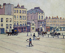
Robert Bevan. The Weigh House, Cumberland Market, c. 1914.
Cumberland Market was a London market between Regent's Park and Euston railway station. It was built in the early 19th century and was London's hay and straw market for a hundred years until the late 1920s. An arm of the Regent's Canal was built to the market. The market was surrounded by modest housing, and in the early 20th century became an artistic community. The original houses were demolished during and after World War II and it is now a housing estate, known as Regent's Park Estate.
The land to the east of John Nash's Regent's Park development had originally been laid out as a service district with small houses for tradesmen and three large squares intended for the marketing of hay, vegetables and meat.,[1][2] Only Cumberland Market, the northernmost square survived as a commercial area. London's hay market relocated here from the Haymarket (near Piccadilly Circus) in 1830 although it was never to prove a great success, being described in 1878 as "never [having] been very largely attended".[3]
The Regent's Canal was developed as a means of delivering goods into the North of London. It linked the Grand Junction Canal's Paddington Arm with the River Thames at Limehouse.[4] The Cumberland Arm was built as a spur off it and led between Nash's Park Village West and Park Village East to the Cumberland Basin which was lined by a collection of wharfs and warehouses. Hay and straw were brought in for sale at the Market and for the nearby Albany Streetcavalrybarracks.[5]Barges, each capable of carrying thirty tons, would also arrive with heavy goods such as stone and lime for building; coal and timber for the neighbouring coach-building and furniture trade. Ice, too, was brought in for the ice-merchant, William Leftwich, who had an icehouse that was eighty-two feet deep and with a capacity of 1,500 tons under the Market.[6] Vegetables and cattle were carried in as well, thus reducing the need for the latter to be driven into the city.
Clarence Market, the next square to the south, was intended to be a centre for the distribution of fresh vegetables brought in from the market gardens of Middlesex. It was later cultivated as a nursery garden and became Clarence Gardens.[7] The houses in Clarence and Cumberland Markets were modest and the work of speculative builders who put up "run-of-the-mill products without the slightest obligation to make architecture."[8] The southernmost square began as York Market but it never found use as a trading place and the name was later changed to Munster Square. Although its houses were tiny, with a single window on each of their three storeys, they were well-designed and perfectly proportioned.[9]
In the NW corner of Cumberland Market, in Albany Street, John Nash had built the Ophthalmic Hospital for Sir William Adams, George IV's oculist. For several years Adams gave his services free to soldiers whose eyesight had been affected in the military campaigns in Egypt. The hospital was closed in 1822 and for a time it was used as a factory for manufacturing Bacon's and Perkin's 'steam guns'. In 1826 it was purchased by Sir Goldsworthy Gurney for the construction of his famed 'steam carriages', one of which made the journey from London to Bath and back, in July 1829. However, unable to market these vehicles Gurney was forced to sell the premises in 1832. Bought by Sir Felix Booth, the gindistiller the building survived as a landmark, although badly bombed, until demolition in 1968.
Park Village East from the Cumberland Arm. From an original study by Thomas Hosmer Shepherd (1793–1864), pub 1831. Produced from Shepherd's series "Metropolitan Improvements; or London in the Nineteenth Century".
Beside the Ophthalmic Hospital was Christ Church (now St. George's Cathedral), built by Nash's assistant, Sir James Pennethorne in 1837 to serve the largely working class district.[10] However, a series of later alterations gradually made the church more appropriate for high-church worship, and in time the windows were filled with stained glass, including a panel by Dante Gabriel Rossetti, whose family worshipped there.[11]
The steeple of Christ Church, dominated Cumberland Market as did the nearby chimney of William Grimble's gin distillery, also in Albany Street. In 1840 Grimble decided to embark on producing vinegar from spirit left over from the distilling process. He went into partnership with Sir Felix Booth, and they set up premises in the North East corner of the Market. The venture was unsuccessful so they turned to the more conventional method of vinegar brewing. The brewery burnt down in 1864 and was rebuilt and extended soon after.[12]
Growth of railways
The growth of the railway network and the opening of Euston Station in 1837 caused enormous upheaval and was one of the factors that led to the rapid decline of the area. Bringing in "noise, dirt, Irishnavvies, and semi-itinerant railway workers"[13]Charles Dickens likened the railway works cutting their way through Camden Town to a "great earthquake".[14] More industry developed in the area than was originally planned as factories began to spring up near the canal and railway and this put even more pressure on land for housing. Houses that were originally built for middle-class families were taken over by incomers. The terraces of Mornington Crescent and Arlington Road, for example, were ideal for multi occupation for as many as nine or ten people could be accommodated in each.[15]
By 1852 the Midland Railway was transporting around a fifth of the total coal to London through both Euston and King's Cross.[citation needed] Ironically the canal proved useful in the construction of both King's Cross and St Pancras in terms of getting the building materials to the site.[citation needed] Although still in use the Regent's Canal carried less and less until by the 1850s the Cumberland Basin was described as "no better than a stagnant putrid ditch".[16]Cholera spread through the families of men who were employed on the barges and in the wharves around it and took hold in the overcrowded neighbourhood.
The housing situation was to become worse in the following decade. Some 4,000 houses were demolished in the area to the east of Cumberland Market to make way for the new St Pancras Station in 1868. As many as 32,000 people were displaced, most with no form of compensation.[17] By the late nineteenth century a dramatic social divide had developed in this part of London with Cumberland Market in the middle. Just over one hundred metres to the west were the wealthy occupants of Nash's Chester Terrace while a short distance to the east were areas characterised by Charles Booth, the social commentator, as being occupied by the very poor, of those in "chronic want".
Throughout its existence the hay market operated for three days a week alongside a general produce market. The central cobbled market place, enclosed by cast-iron posts linked with chains, was surrounded by modest houses of varying styles. Most of the houses were of three storeys, some with a basement. Although originally they do not appear to have had shops the lower floors of many were subsequently converted to business.[18] Twenty-one separate businesses are recorded in Cumberland Market at the beginning of the twentieth century together with four pubs.
The canal had proved to be a very efficient means of bringing in stone to the Cumberland Basin and a number of monumental masonry and statuary businesses had sprung up in the Euston Road to take advantage of this.
Artistic community
As well as monumental statuary the availability of stone, combined with cheap rents and its proximity to the centre of town had attracted a number of sculptors and artists to set up studios in the Cumberland Market area. Amongst the former were Mario Raggi; John Henry Foley and Sir Thomas Brock.[19] Sir Frederic (later Lord) Leighton also had his sculptor's studio in Osnaburgh Street.
Fred Winter, the treasurer of the New English Art Club, sculpted at No.13 Robert Street and Walter Sickert painted in the next door studio in 1894 sharing it for a while with his former master Whistler. Some years later C.R.W. Nevinson rented the same studio and it was there that he painted his works for his second exhibition of War Paintings at the Leicester Galleries of 1918.[20]
In 1909-10 Sickert had taken a studio at No. 21 Augustus Street, which he called the "Vinegar Factory" as it had been part of Grimble's Factory.[21] Here he taught etching. His Cumberland Market painting of ca. 1910 which was made at the south end of Augustus Street shows the side window of Charles Chase's bakers shop at No. 24 Cumberland Market.[22]
Today Cumberland Market is best remembered as the home of Robert Bevan's Cumberland Market Group for it was in his first floor studio of No. 49 that he and his colleagues held their Saturday afternoon "At Homes" in the early days of World War I.
The artist William Roberts also worked in the Market at this time and mentioned other neighbours as having been Bernard Meninsky, John Flanagan, Colin Gill, and Geoffrey Nelson.[23]
In her "The Hay-Market" of 1914 Charlotte Mew, the poet, gave a vivid picture of Cumberland Market and its residents. Her account of a woman walking across it with her young daughter might almost have been a description of one of Bevan's better-known paintings of this period.[24]
Another writer attracted to the area was the American "Tramp Poet" Harry Kemp, who rented two rooms in the Market in late 1913.[25] It was there one morning, woken from an absinthe-induced hangover, by the tap-tapping of a blind man in the Market below that he wrote "Blind".
Social conditions
A few years beforehand, concerned by the poor conditions in which many were living Mary Neal, a philanthropist, set out to help girls working in the dressmaking trade. With Emmeline Pethick-Lawrence she established the Espérance Girls' Club at No. 50 Cumberland Market. This was open nearly every night of the week from 8 to 10 o'clock. One evening every week was set apart for a singing class, another for musical drill, another for games, or sewing or cooking.[26] Having heard of Cecil Sharp's collection of folk songs in 1905 she asked him for suitable ones that might be taught to the girls. This proved to be such a success that he was asked to recommend dances to go with the songs. Within a short time the Espérance girls were putting on demonstrations around the country.[27] Sharp collaborated with Herbert MacIlwaine, the musical director of the club, to produce the first of the Morris books.
Mary Neal had been an early supporter of the Women's Social and Political Union and the Espérance Club danced at many of their events. This proved to be one of the reasons for Sharp and Neal to fall out and although she went on to publish two Espérance Morris books, the Club closed during World War I.
The theme of social change remained strong in Cumberland Market, for in 1916 Miss M.M. Jeffery, who had been the reformer Octavia Hill's secretary, took over three rooms at No. 42. She had been appointed to manage the Cumberland Market (London) Estate of the Commissioners of Crown Lands (later the Crown Estate Commissioners). This was an estate 'of about 850 houses divided into about 2,000 tenancies, occupied by a population of about 7,000'.[28]
Decline
A market continued on the site right up until the late 1920s, and the last trading barges ceased sometime in 1930. Local businesses were in terminal decline and by 1931 only five remained and the King's Head was the sole surviving pub. In the same year the buildings on the north side of the Market were demolished, including Grimble's Vinegar Factory, and replaced by council housing.
In August 1938 the Cumberland Basin was dammed off and drained and in the next two years it was formally abandoned. By 15 January 1941 the Basin had been filled in with rubble from London's bombing and in the years following World War II the site was covered with topsoil and turned into allotments.[29]
Being so close to both Euston and King's Cross stations it was inevitable that the area would have been so heavily bombed during World War II. A V1 rocket landed on the NE corner in 1944 and the buildings on the SE corner were damaged beyond repair. General blast damage was also sustained in the SW corner.[30]
The remaining buildings were demolished in 1950 and in 1951 the Crown Estate Commissioners sold the 32 acres (130,000m2) on which Munster Square, Clarence Gardens and Cumberland Market stood to St Pancras Borough Council for the building of a housing estate, known as Regent's Park Estate.
Notes and references
↑ Much of this has been taken from "Straws from Cumberland Market" by Patrick Baty in the catalogue for "A Countryman in Town: Robert Bevan and the Cumberland Market Group" at Southampton City Art Gallery. The exhibition ran from 26 September to 14 December 2008 before moving to Abbot Hall Art Gallery in Kendal from 13 January to 21 March 2009.
↑ Ann Saunders. Regent's Park. A Study of the Development of the Area from 1086 to the Present Day. David & Charles. 1969. p.83.
↑ Edward Walford. Old and New London. 1878. p.299.
↑ Malcolm Holmes. Euston & Regent's Park 1870. Old Ordnance Survey Maps. Sheet 49. Consett. Alan Godfrey. 2000.
↑ This was replaced by a ship constantly engaged in bringing ice from Norway to the Thames, where it was transferred to Regent's Canal barges. This was eventually filled in with clay from the work on the Cockfostersunderground railway extension in the early 1930s.
↑ John Summerson. Georgian London. Pleiades Books. 1945. p.167.
↑ John Summerson. The Life and Works of John Nash Architect. George Allen & Unwin. 1980. p.128.
↑ See photograph of 1936 in Michael Mansbridge. John Nash. A Complete Catalogue. Phaidon. 1991. p.183.
↑ The church was built in a severe Greek Revival style and is now St. George's Greek Orthodox Cathedral. George Orwell's funeral was held here in 1950.
↑ Geoffrey Tyack. Sir James Pennethorne and the making of Victorian London. Cambridge University Press. 1992. pp.35-36.
↑ John Yeates. NW1. The Camden Town Artists. Heale Gallery. 2007. p.8.
↑ 'The Cholera'. The Medical Times and Gazette. New Series, Volume Seven. 2 July – 31 December 1853. p.429. In 1847 Pickfords transferred their entire freight business from the canals to the railways.
↑ Steven P. Swensen. Mapping Poverty in Agar Town: Economic Conditions Prior to the Development of St. Pancras Station in 1866. LSE. June 2006 (p.10) quoting "Working Man", II (8 Sept. 1866), pp.110-11.
↑ "The Hay-Market." The New Statesman, 14 February 1914. pp. 595-597. Compare this with Robert Bevan's Cumberland Market.
↑ William Brevda. Harry Kemp: The Last Bohemian. Bucknell University Press. 1986. p. 94.
↑ Emmeline Pethick-Lawrence. "Working Girls' Clubs" in W. Reason (ed.) University and Social Settlements. Methuen. 1898. p.104.
↑ Janet Dowling. "Revival of Morris dance in early twentieth century". Morris Federation Newsletter. Summer 2007. pp.17-19.
↑ Marion Brion. Women in the Housing Service. Routledge. 1995.
↑ Hugh Compton & Alan Faulkner. "The Cumberland Market Branch of the Regent's Canal". Journal of the Railway and Canal Historical Society. 2006. No.194, pp.254-261.
↑ The London County Council Bomb Damage Maps 1939–1945. London Topographical Society. LTS Publication No. 164. 2005. Map 49.
King's Cross is a district in the London Boroughs of Camden and Islington, on either side of Euston Road in north London, England, 1.5 miles (2.4 km) north of Charing Cross, bordered by Barnsbury to the north, Clerkenwell to the southeast, Angel to the east, Holborn and Bloomsbury to the south, Euston to the west and Camden Town to the northwest. It is served by two major rail termini, St Pancras and King's Cross. King's Cross station is the terminus of one of the major rail routes between London and the North.
Camden Town, often shortened to Camden, is an area in the London Borough of Camden, around 2.5 miles (4.1 km) north-northwest of Charing Cross. Historically in Middlesex, it is identified in the London Plan as one of 34 major centres in Greater London.
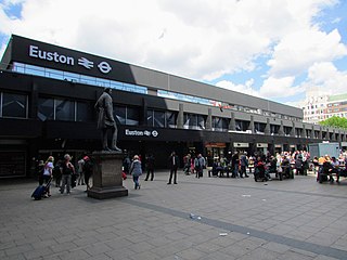
Euston railway station is a major central London railway terminus managed by Network Rail in the London Borough of Camden. It is the southern terminus of the West Coast Main Line, the UK's busiest inter-city railway. Euston is the tenth-busiest station in Britain and the country's busiest inter-city passenger terminal, being the gateway from London to the West Midlands, North West England, North Wales and Scotland.
Euston Road is a road in Central London that runs from Marylebone Road to King's Cross. The route is part of the London Inner Ring Road and forms part of the London congestion charge zone boundary. It is named after Euston Hall, the family seat of the Dukes of Grafton, who had become major property owners in the area during the mid-19th century.
Somers Town is an inner-city district in North West London. It has been strongly influenced by the three mainline north London railway termini: Euston (1838), St Pancras (1868) and King's Cross (1852), together with the Midland Railway Somers Town Goods Depot (1887) next to St Pancras, where the British Library now stands. It was named after Charles Cocks, 1st Baron Somers (1725–1806). The area was originally granted by William III to John Somers (1651–1716), Lord Chancellor and Baron Somers of Evesham.
Regent's Park is one of the Royal Parks of London. It occupies 410 acres (170 ha) in north-west Inner London, administratively split between the City of Westminster and the Borough of Camden. In addition to its large central parkland and ornamental lake, it contains various structures and organizations both public and private, generally on its periphery, including Regent's University and London Zoo.
Limehouse Basin is a body of water 2 miles east of London Bridge that is also a navigable link between the River Thames and two of London's canals. First dug in 1820 as the eastern terminus of the new Regent's Canal, its wet area was less than 5 acres originally, but it was gradually enlarged in the Victorian era, reaching a maximum of double that size, when it was given its characteristic oblique entrance lock, big enough to admit 2,000-ton ships.
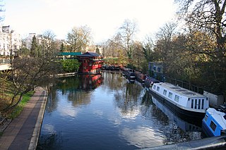
Regent's Canal is a canal across an area just north of central London, England. It provides a link from the Paddington Arm of the Grand Union Canal, 550 yards (500 m) north-west of Paddington Basin in the west, to the Limehouse Basin and the River Thames in east London. The canal is 8.6 miles (13.8 km) long.
Cumberland Terrace is a neoclassical terrace on the eastern side of Regent's Park in the London Borough of Camden, completed in 1826. It is a Grade I listed building.
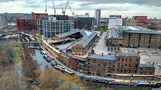
King's Cross Central (KXC) is a mixed-use development in the north-east of central London. The site is owned and controlled by the King's Cross Central Limited Partnership. It consists of approximately 67 acres (27 ha) of former railway lands to the north of King's Cross and St Pancras mainline railway stations. The site is largely determined by three boundaries: the existing East Coast Main Line railway leading out of King's Cross; York Way, a road marking the division between Camden and Islington boroughs; and the new railway line, High Speed 1 (HS1), formerly known as the Channel Tunnel Rail Link, which curves around the site to the north and west.
Grosvenor Canal was a canal in the Pimlico area of London, opened in 1824. It was progressively shortened, as first the railways to Victoria Station and then the Ebury Bridge housing estate were built over it. It remained in use until 1995, enabling barges to be loaded with refuse for removal from the city, making it the last canal in London to operate commercially. A small part of it remains within the Grosvenor Waterside development.
Regent's Park Estate is a large housing estate in the London Borough of Camden. The estate consists of nearly 2,000 homes across 49 buildings and lies on either side of Robert Street, between Albany Street and Hampstead Road. It is immediately to the east of the Regent's Park estate owned by the Crown Estate. The estate includes the sites of Cumberland Market, Munster Square and Clarence Gardens.
Cumberland Basin was a canal basin near to Euston railway station in London, England and a part of the Regent's Canal. It was originally known as Jew's Harp Basin in the 1880s, after a nearby public house.
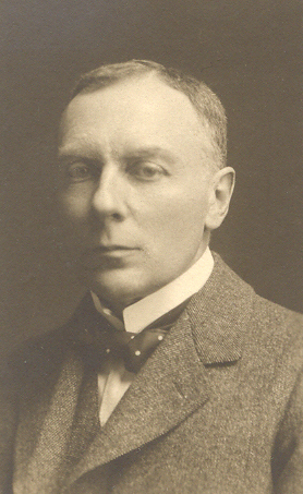
Robert Polhill Bevan was a British painter, draughtsman and lithographer who was married to the Polish-born artist Stanisława de Karłowska. He was a founding member of the Camden Town Group, the London Group, and the Cumberland Market Group.
The Cumberland Market Group was a short-lived artistic grouping in early twentieth century London. The group met in the studio of Robert Bevan in Cumberland Market, the old hay and straw market off Albany Street, and held one exhibition.
Maida Hill Tunnel is a canal tunnel on the Regent's Canal in London, England. The two other tunnels on the Regent's Canal are Islington Tunnel and Eyre's Tunnel.
The London Borough of Camden was created in 1965 from the former area of the metropolitan boroughs of Hampstead, Holborn, and St Pancras, which had formed part of the County of London. The borough was named after Camden Town, which had gained its name from Charles Pratt, 1st Earl Camden in 1795. Since the 17th century, many famous people have lived in its various districts and neighbourhoods.
The London Borough of Camden is a borough in Inner London, England. Camden Town Hall, on Euston Road, lies 1.4 mi (2.3 km) north of Charing Cross. The borough was established on 1 April 1965 from the former metropolitan boroughs of Holborn, St Pancras and Hampstead.
This is a list of the etymology of street names in the area of Regent's Park in London ; the area has no formal boundaries, though it generally thought to be delimited by Prince Albert Road to the north, Park Village East and Hampstead Road/the Euston railway line/Eversholt Street to the east, Euston Road and Marylebone Road to the south and Park Road and Baker Street to the west.
Chalton Street Market is a street market in Camden, North London.
This page is based on this Wikipedia article Text is available under the CC BY-SA 4.0 license; additional terms may apply. Images, videos and audio are available under their respective licenses.