Shelby, Oceana County, Michigan

Last updated

Shelby, Michigan
Oceana County Michigan Incorporated and Unincorporated areas Shelby Highlighted.svg
Location of Shelby, Michigan
Coordinates: 43°36′42″N86°21′52″W / 43.61167°N 86.36444°W / 43.61167; -86.36444
Country United States
State Michigan
County Oceana
Area
[1]
  Total1.64 sq mi (4.25 km2)
  Land1.64 sq mi (4.25 km2)
  Water0.00 sq mi (0.00 km2)
Elevation
817 ft (249 m)
Population
 (2020)
  Total1,964
  Density1,196.10/sq mi (461.80/km2)
Time zone UTC-5 (Eastern (EST))
  Summer (DST) UTC-4 (EDT)
ZIP code
49455
Area code 231
FIPS code 26-72840 [2]
GNIS feature ID1621579 [3]
Website Village website

Shelby is a village in Oceana County in the U.S. state of Michigan. The population was 2,065 at the 2010 census.

Contents

Schools

Shelby Public Schools operate within the village boundaries. There are four schools which serve the village:

Geography

According to the United States Census Bureau, the village has a total area of 1.70 square miles (4.40 km2), all land. [4]

Major highways

Demographics

Historical population
CensusPop.Note
1880 81
1890 9941,127.2%
1900 1,0818.8%
1910 1,26016.6%
1920 1,2882.2%
1930 1,152−10.6%
1940 1,36718.7%
1950 1,5009.7%
1960 1,6036.9%
1970 1,7036.2%
1980 1,624−4.6%
1990 1,87115.2%
2000 1,9142.3%
2010 2,0657.9%
2020 1,964−4.9%
U.S. Decennial Census [5]

2020 census

As of the 2020 United States Census, [6] [7] there were 2,520 people living in the village. 42.7% were non-Hispanic White, 1.9% Black or African American, 0.1% Asian, 1.4% Native American, and 13.2% of two or more races. 51.6% were Hispanic or Latino (which makes it the highest percent and only community with a Hispanic-majority in the state).

2010 census

As of the census [8] of 2010, there were 2,065 people, 689 households, and 496 families living in the village. The population density was 1,214.7 inhabitants per square mile (469.0/km2). There were 772 housing units at an average density of 454.1 per square mile (175.3/km2). The racial makeup of the village was 68.7% White, 0.4% African American, 1.5% Native American, 0.2% Asian, 25.5% from other races, and 3.7% from two or more races. Hispanic or Latino of any race were 45.6% of the population.

There were 689 households, of which 41.8% had children under the age of 18 living with them, 51.8% were married couples living together, 13.6% had a female householder with no husband present, 6.5% had a male householder with no wife present, and 28.0% were non-families. 24.7% of all households were made up of individuals, and 13.8% had someone living alone who was 65 years of age or older. The average household size was 2.98 and the average family size was 3.56.

The median age in the village was 30.1 years. 33.2% of residents were under the age of 18; 10.1% were between the ages of 18 and 24; 24.7% were from 25 to 44; 19.5% were from 45 to 64; and 12.5% were 65 years of age or older. The gender makeup of the village was 47.9% male and 52.1% female.

2000 census

As of the census [2] of 2000, there were 1,914 people, 698 households, and 504 families living in the village. The population density was 1,098.8 inhabitants per square mile (424.2/km2). There were 749 housing units at an average density of 430.0 per square mile (166.0/km2). The racial makeup of the village was 81.35% White, 0.10% African American, 1.41% Native American, 0.05% Asian, 0.10% Pacific Islander, 15.41% from other races, and 1.57% from two or more races. Hispanic or Latino of any race were 27.27% of the population.

There were 698 households, out of which 38.3% had children under the age of 18 living with them, 55.0% were married couples living together, 13.6% had a female householder with no husband present, and 27.7% were non-families. 24.4% of all households were made up of individuals, and 14.6% had someone living alone who was 65 years of age or older. The average household size was 2.73 and the average family size was 3.26.

In the village, the population was spread out, with 31.5% under the age of 18, 10.3% from 18 to 24, 25.6% from 25 to 44, 17.9% from 45 to 64, and 14.7% who were 65 years of age or older. The median age was 33 years. For every 100 females, there were 88.0 males. For every 100 females age 18 and over, there were 80.6 males.

The median income for a household in the village was $28,710, and the median income for a family was $36,607. Males had a median income of $28,875 versus $21,300 for females. The per capita income for the village was $13,468. About 13.9% of families and 16.7% of the population were below the poverty line, including 24.1% of those under age 18 and 6.3% of those age 65 or over.

See also

Related Research Articles

<span class="mw-page-title-main">Coosa County, Alabama</span> County in Alabama, United States

Coosa County is located in the east central portion of the U.S. state of Alabama. As of the 2020 census the population was 10,387. Its county seat is Rockford. Its name derives from a town of the Creek tribe and the Coosa River, which forms one of the county borders.

<span class="mw-page-title-main">Shelby County, Alabama</span> County in Alabama, United States

Shelby County is located in the central portion of the U.S. state of Alabama. As of the 2020 census the population was 223,024, making it the sixth-most populous county in Alabama. The county seat is Columbiana. Its largest city is Alabaster. The county is named in honor of Isaac Shelby, Governor of Kentucky from 1792 to 1796 and again from 1812 to 1816. Shelby County is included in the Birmingham–Hoover, AL Metropolitan Statistical Area.

<span class="mw-page-title-main">Kimberly, Idaho</span> City in Idaho, United States

Kimberly is a city in Twin Falls County, Idaho, United States. The population was 3,264 at the 2010 census, up from 2,614 in 2000. It is part of the Twin Falls Metropolitan Statistical Area.

<span class="mw-page-title-main">Morristown, Indiana</span> Town in Indiana, United States

Morristown is a town in Hanover Township, Shelby County, in the U.S. state of Indiana. The population was 1,218 at the 2010 census.

<span class="mw-page-title-main">Harlan, Iowa</span> City in Iowa, United States

Harlan is a city in Shelby County, Iowa, along the West Nishnabotna River. The population was 4,893 at the time of the 2020 census. It is the county seat of Shelby County.

<span class="mw-page-title-main">Three Rivers, Massachusetts</span> Former CDP in Massachusetts, United States

Three Rivers is a village and former census-designated place (CDP) in the city of Palmer in Hampden County, Massachusetts, United States. It is part of the Springfield, Massachusetts Metropolitan Statistical Area. It is named for the confluence of the Ware and Quaboag rivers, which form the Chicopee River.

Boston Township is a civil township of Ionia County in the U.S. state of Michigan. As of the 2020 census, the township population was 6,021.

<span class="mw-page-title-main">Hart, Michigan</span> City in Michigan, United States

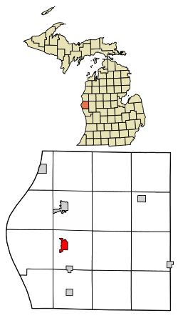
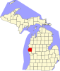
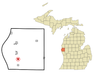
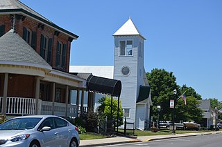
Hart is a city and county seat of Oceana County, Michigan. The population was 2,126 at the time of the 2010 census. The city is located within Hart Township, but is politically independent.

<span class="mw-page-title-main">New Era, Michigan</span> Village in Michigan, United States

New Era is a village in Shelby Township, Oceana County in the U.S. state of Michigan. The population was 451 at the 2010 census.

<span class="mw-page-title-main">Perry, Michigan</span> City in Michigan, United States

Perry is a city in Shiawassee County in the U.S. state of Michigan. The population was 2,188 at the 2010 census. The city is surrounded by Perry Township, but the two are administered autonomously.

<span class="mw-page-title-main">Leonard, Missouri</span> Village in Missouri, United States

Leonard is a village in northwestern Shelby County, Missouri, United States. The population was 57 at the 2020 census.

<span class="mw-page-title-main">Shelbyville, Missouri</span> City in Missouri, United States

Shelbyville is a city in Shelby County, Missouri, United States. The population was 518 at the 2020 census. It is the county seat of Shelby County.

<span class="mw-page-title-main">Waterville, Ohio</span> City in Ohio, United States

Waterville is a city in Lucas County, Ohio, United States, along the Maumee River. A suburb of Toledo, the population was 6,003 at the 2020 census.

<span class="mw-page-title-main">Botkins, Ohio</span> Village in Ohio, United States

Botkins is a village in Shelby County, Ohio, United States. The population was 1,155 at the 2020 census.

<span class="mw-page-title-main">Jackson Center, Ohio</span> Village in Ohio, United States

Jackson Center is a village in Shelby County, Ohio, United States. The population was 1,441 at the 2020 census.

<span class="mw-page-title-main">Kettlersville, Ohio</span> Village in Ohio, United States

Kettlersville is a village in Shelby County, Ohio, United States. The population was 164 at the 2020 census.

<span class="mw-page-title-main">North Vandergrift-Pleasant View, Pennsylvania</span> Former CDP in Pennsylvania, United States

North Vandergrift-Pleasant View was a census-designated place (CDP) in Armstrong County, Pennsylvania, United States. The population was 1,355 at the 2000 census. For the 2010 census, the area was split into two CDPs, North Vandergrift and Pleasant View.

<span class="mw-page-title-main">Gray Court, South Carolina</span> Town in South Carolina, United States

Gray Court is a town in Laurens County, South Carolina, United States. The population was 795 at the 2010 census. It is part of the Greenville–Mauldin–Easley Metropolitan Statistical Area.

<span class="mw-page-title-main">Haugen, Wisconsin</span> Village in Wisconsin, United States

Haugen is a village in Barron County in the U.S. state of Wisconsin. The population was 287 at the 2010 census.

<span class="mw-page-title-main">Marion, Waushara County, Wisconsin</span> Town in Wisconsin, United States

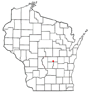
Marion is a town in Waushara County, Wisconsin, United States. The population was 2,065 at the 2000 census. The unincorporated communities of Silver Lake and Spring Lake are located in the town. The ghost town of Rodney was also located partially in the town.

References

  1. "2020 U.S. Gazetteer Files". United States Census Bureau. Retrieved May 21, 2022.
  2. 1 2 "U.S. Census website". United States Census Bureau . Retrieved January 31, 2008.
  3. "US Board on Geographic Names". United States Geological Survey. October 25, 2007. Retrieved January 31, 2008.
  4. "US Gazetteer files 2010". United States Census Bureau. Archived from the original on January 25, 2012. Retrieved November 25, 2012.
  5. "Census of Population and Housing". Census.gov. Retrieved June 4, 2015.
  6. "Zip Atlas". Community Profile . Retrieved May 9, 2024.
  7. "Data USA". Community Profile . Retrieved May 9, 2024.
  8. "U.S. Census website". United States Census Bureau . Retrieved November 25, 2012.

43°36′31″N86°21′50″W / 43.60861°N 86.36389°W / 43.60861; -86.36389