Shelley, Idaho | |
---|---|
Coordinates: 43°22′46″N112°7′26″W / 43.37944°N 112.12389°W | |
Country | United States |
State | Idaho |
County | Bingham |
Area | |
• Total | 1.81 sq mi (4.68 km2) |
• Land | 1.81 sq mi (4.68 km2) |
• Water | 0.00 sq mi (0.00 km2) |
Elevation | 4,633 ft (1,412 m) |
Population | |
• Total | 4,409 |
• Estimate (2019) [3] | 4,466 |
• Density | 2,472.87/sq mi (954.83/km2) |
Time zone | UTC-7 (Mountain (MST)) |
• Summer (DST) | UTC-6 (MDT) |
ZIP code | 83274 |
Area code(s) | 208, 986 |
FIPS code | 16-73450 |
GNIS feature ID | 0397154 |
Website | ci |
Shelley is a city in Bingham County, Idaho, United States. The population was 4,409 at the 2010 census.
Since 1927 Shelley has been home to the "Idaho Annual Spud Day", which is celebrated on the 3rd Saturday of September. It typically features a parade, live bands, a Spud Tug, a spud-picking Contest, and free baked potatoes. [4]
Shelley was established in 1904. It was named for John F. Shelley, who moved to the area in 1892. He'd moved to the area intending to open a small store, and needed lumber and other supplies to build it. Since the site was some distance from the nearest existing community, he asked the railroad company to make a special stop to offload the supplies he'd ordered. They consented, provided he could offload the supplies in under 20 minutes. His daughter, Lottie, wrote the following in her personal history:
With the help of Chris Mickelson and others, the lumber was thrown off the train on both sides of the track. Later a spur was put in here by the railroad company.
Now they needed a name for the town. Mother suggested 'Shelco'; Father said, 'Shelton,' so they drew cuts and Mother won."
Shelco was submitted to the railroad company and they replied: 'Call your town what you wish, but we have already named the spur, Shelley '. That is how the town got its name.
— Charlotte Shelley, [5]
On September 4, 1902 a large fire destroyed seven buildings on State Street. Only two buildings, a general merchandise store and Nalder's furniture store, were saved. Soren Yorgesen, a local Justice of the Peace and proprietor of the first hotel in Shelley recounts the experience as follows:
...One windy afternoon in the heat of the summer, a fire started in a small grocery store operated by James Jensen. It did not take long until the wind was fanning a flame that wiped out quite a long string of frame buildings - two saloons, restaurant, Odd Fellows Hall, Post Office and Confectionery, Grocery Store, and dwelling.
— Soren Yorgesen, [5]
Shelley is located at 43°22′46″N112°7′26″W / 43.37944°N 112.12389°W (43.379490, -112.123846). [6]
According to the United States Census Bureau, the city has a total area of 1.81 square miles (4.69 km2), all of it land. [7]
Shelley is located on the eastern side of the Snake River, facing the Blackfoot Mountains.
Beginning at the fire department, across the street from Shelley High School, lies the Shelley Greenbelt. This fully paved trail, a collaborative project between Shelley and Bingham County, follows the Snake River for 2 miles before terminating at North Bingham County Park. The trail includes picnic tables, benches, and activities for families throughout. [8]
In September, 1927, Shelley hosted its first Spud Day (Now called The Idaho Spud Day), now a yearly tradition usually taking place on the third Saturday each September. During this first Spud day, 10,000 people were served hot baked potatoes with butter. This tradition continues each year, along with several other events. These events have included a parade that features the various clubs and bands of the schools in the area, as well as local businesses and groups. Other events include the spud tug - where teams play a game of tug of war over a pit of mashed potatoes blended together in a cement truck, spud run - a set of 1-mile and 5k races, [9] concerts, fairground booths and games, and a demolition derby hosted at nearby North Bingham County Park. [10] This event is usually the beginning of Spud Harvest, a 2-week break from school to allow students to assist in the seasons potato harvest.
Census | Pop. | Note | %± |
---|---|---|---|
1910 | 537 | — | |
1920 | 1,223 | 127.7% | |
1930 | 1,447 | 18.3% | |
1940 | 1,751 | 21.0% | |
1950 | 1,856 | 6.0% | |
1960 | 2,612 | 40.7% | |
1970 | 2,614 | 0.1% | |
1980 | 3,300 | 26.2% | |
1990 | 3,536 | 7.2% | |
2000 | 3,813 | 7.8% | |
2010 | 4,409 | 15.6% | |
2019 (est.) | 4,466 | [3] | 1.3% |
U.S. Decennial Census [11] |
As of the census [2] of 2010, there were 4,409 people, 1,445 households, and 1,123 families residing in the city. The population density was 2,435.9 inhabitants per square mile (940.5/km2). There were 1,531 housing units at an average density of 845.9 per square mile (326.6/km2). The racial makeup of the city was 89.0% White, 0.3% African American, 0.8% Native American, 0.7% Asian, 0.2% Pacific Islander, 7.0% from other races, and 2.1% from two or more races. Hispanic or Latino of any race were 14.0% of the population.
There were 1,445 households, of which 49.1% had children under the age of 18 living with them, 61.6% were married couples living together, 12.1% had a female householder with no husband present, 4.0% had a male householder with no wife present, and 22.3% were non-families. 19.6% of all households were made up of individuals, and 7.1% had someone living alone who was 65 years of age or older. The average household size was 3.05 and the average family size was 3.53.
The median age in the city was 27.8 years. 36.1% of residents were under the age of 18; 9.6% were between the ages of 18 and 24; 25.6% were from 25 to 44; 19.2% were from 45 to 64; and 9.5% were 65 years of age or older. The gender makeup of the city was 49.4% male and 50.6% female.
As of the census [12] of 2000, there were 3,813 people, 1,201 households, and 989 families residing in the city. The population density was 2,884.5 inhabitants per square mile (1,113.7/km2). There were 1,253 housing units at an average density of 947.9 per square mile (366.0/km2). The racial makeup of the city was 89.93% White, 0.18% African American, 0.68% Native American, 0.26% Asian, 0.03% Pacific Islander, 6.74% from other races, and 2.18% from two or more races. Hispanic or Latino of any race were 11.78% of the population.
There were 1,201 households, out of which 48.9% had children under the age of 18 living with them, 67.0% were married couples living together, 13.0% had a female householder with no husband present, and 17.6% were non-families. 15.3% of all households were made up of individuals, and 7.2% had someone living alone who was 65 years of age or older. The average household size was 3.14 and the average family size was 3.50.
In the city, the population was spread out, with 35.6% under the age of 18, 11.5% from 18 to 24, 25.5% from 25 to 44, 16.8% from 45 to 64, and 10.6% who were 65 years of age or older. The median age was 27 years. For every 100 females, there were 96.2 males. For every 100 females age 18 and over, there were 90.3 males.
The median income for a household in the city was $39,318, and the median income for a family was $41,223. Males had a median income of $32,154 versus $20,121 for females. The per capita income for the city was $13,921. About 7.9% of families and 9.6% of the population were below the poverty line, including 10.6% of those under age 18 and 2.0% of those age 65 or over.
Power County is a county located in the U.S. state of Idaho. As of the 2020 Census, the county had a population of 7,878. The county seat and largest city is American Falls. The county was created by the Idaho Legislature on January 30, 1913, by a partition of Cassia County. It is named for an early hydroelectric power plant (1902) at the American Falls.
Oneida County is a county located in the U.S. state of Idaho. As of the 2020 Census the county had a population of 4,564. The county seat and largest city is Malad City. Most of the county's population lives in Malad City and the surrounding Malad Valley.
Jefferson County is a county located in the U.S. state of Idaho. As of the 2020 Census, the county's population was 30,891. The county seat and largest city is Rigby. The county was established in 1913 and named after Thomas Jefferson, the third U.S. President. Jefferson County is part of the Idaho Falls, ID Metropolitan Statistical Area.
Butte County is a rural county located in the U.S. state of Idaho. As of the 2020 census, the population was 2,574, making it the third-least populous county in Idaho. Its county seat and largest city is Arco. The county was established in 1917 from parts of Bingham, Blaine, and Jefferson counties. The county gained territory in the Clyde area from Custer County in 1937 to reach its present boundary.
Bonneville County is a county located in the U.S. state of Idaho. As of the 2020 census, the county had a population of 123,964, making it the fourth-most populous county in Idaho and the most populous in eastern Idaho. Its county seat and largest city is Idaho Falls. Bonneville County was established in 1911 and named after Benjamin Bonneville (1796–1878), a French-born officer in the U.S. Army, fur trapper, and explorer in the American West. Benjamin was the son of Nicholas Bonneville of France, an Illuminati member who had written the "Illuminati Manifesto for World Revolution" in 1792, which played a significant role in the French revolution. Bonneville County is part of the Idaho Falls Metropolitan Statistical Area.
Bingham County is a county in the U.S. state of Idaho. As of the 2020 United States Census, the population was 47,992. The county seat and largest city is Blackfoot.
Eagle is a city in Ada County, Idaho, United States, 10 miles (16 km) northwest of Boise. The population was 30,346 at the 2020 census.
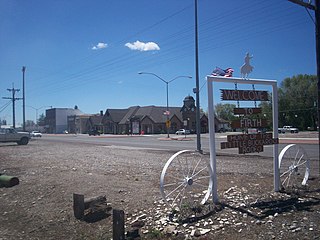
Fort Hall is a census-designated place (CDP) in the southeastern part of the U.S. state of Idaho which is split between Bannock County in the south and Bingham County in the north. It is located on the Fort Hall Indian Reservation along the Snake River north of Pocatello and near the site of the original Fort Hall in the Oregon Country. The population was 3,201 at the 2010 census.
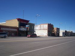
Aberdeen is a city in Bingham County, Idaho, United States. The community was named after Aberdeen, in Scotland. The population was 1,994 at the 2010 census, up from 1,840 in 2000.
Blackfoot is a city in Bingham County, Idaho, United States. The population was 12,355 at the time of the 2020 census. The city is the county seat of Bingham County. Blackfoot is the principal city of the Blackfoot, Idaho, Micropolitan Statistical Area, which includes Bingham County.
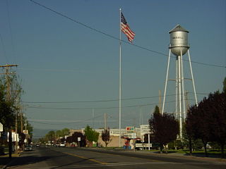
Firth is a city in Bingham County, Idaho, United States. The population was 517 at the 2020 census.
Dayton is a city in Franklin County, Idaho, United States. The population was 463 at the 2010 census. It is part of the Logan, Utah-Idaho Metropolitan Statistical Area.
Lewisville is a city in Jefferson County, Idaho, United States. The population was 458 at the 2010 census.
Deary is a city in Latah County, Idaho. The population was 506 at the time of the 2010 census, down from 552 in 2000. It is located 24 miles (39 km) east of Moscow and 43 miles (69 km) northeast of Lewiston.
Heyburn is a city in Minidoka County, Idaho, United States. The population was 3,700 at the 2020 census, up from 3,089 in 2010. It is part of the Burley micropolitan area.
Driggs is a city in the western United States in eastern Idaho, and is the county seat of Teton County. Part of the Jackson, WY-ID Micropolitan Statistical Area, it is located in Teton Valley, the headwaters of the Teton River. The population was 1,660 at the 2010 census, up from 1,100 in 2000.
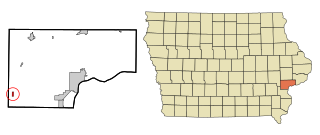
Conesville is a city in Muscatine County, Iowa, United States. The population was 352 at the 2020 census. It is part of the Muscatine Micropolitan Statistical Area.
Bingham Lake is a city in Cottonwood County, Minnesota, United States. The population was 126 at the 2010 census.
Merrill is a city in Klamath County, Oregon, United States. The population was 844 at the 2010 census.
Ridgefield is a city in northern Clark County, Washington, United States. The population was 10,319 at the time of the 2020 census, up from 4,763 in 2010, making it the fastest growing city in the state of Washington.