Sandwich is a town and civil parish in the Dover District of Kent, south-east England. It lies on the River Stour and has a population of 4,985. Sandwich was one of the Cinque Ports and still has many original medieval buildings, including several listed public houses and gates in the old town walls, churches, almshouses and the White Mill. While once a major port, it is now 2 miles (3 km) from the sea due to the disappearance of the Wantsum Channel. Its historic centre has been preserved. Sandwich Bay is home to nature reserves and two world-class golf courses, Royal St George's and Prince's. The town is also home to many educational and cultural events. Sandwich also gave its name to the food by way of John Montagu, 4th Earl of Sandwich, and the word sandwich is now found in several languages.

Eythorne is a civil parish and small village located 7.3 miles north-northwest of Dover in Kent, with a combined population of approximately 2,500 residents including nearby villages Barfrestone and Elvington. Although not classed as one of the former pit villages of Kent, it was only about a mile from Tilmanstone – which closed in 1986. Today many of its residents commute to work in Dover, Deal and Canterbury.
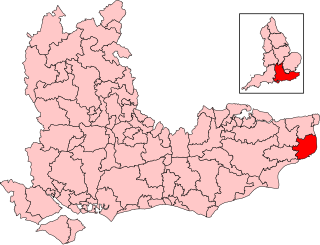
Dover is a local government district in Kent, England. It is named after its largest town, the port town of Dover. The council is based in Whitfield on the outskirts of Dover. The district also covers the towns of Deal, Sandwich and Walmer as well as the surrounding rural areas.

Reculver is a village and coastal resort about 3 miles (5 km) east of Herne Bay on the north coast of Kent in south-east England. It is in the ward of the same name, in the City of Canterbury district of Kent.

Eastry is a village and civil parish in the Dover district, in Kent, England, around 2+1⁄2 miles (4 km) southwest of Sandwich. It was voted "Kent Village of the Year 2005". The parish includes the hamlets of Heronden and Selson. In 2011 the parish had a population of 2492.

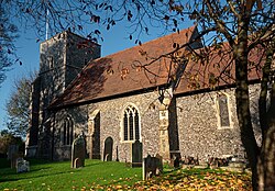
Ash is a village and civil parish in the Dover district of east Kent about three miles west of Sandwich.

Wingham is a village and civil parish in the Dover District of Kent, England. The village lies along the ancient coastal road, now the A257, from Richborough to London, and is close to Canterbury.

Barfrestone is a village and a former civil parish, now in the parish of Eythorne, in the Dover district, in east Kent, England. It is between Shepherdswell, Eythorne and Nonington, close to the former pit villages of Elvington and Snowdown. In 1931 the parish had a population of 91. On 1 April 1935 the parish was abolished and merged with Eythorne.
Dover and Deal is a constituency represented in the House of Commons of the UK Parliament since 2024 by Mike Tapp representing the Labour Party.

Elvington is a small pit village on a ridge in between Canterbury and Dover in the county of Kent in Southeast England. Located near Eythorne, Elvington was mostly built in the early 20th century to serve the nearby coal mine at Tilmanstone, as were other Kent Coalfield villages including Snowdown, Aylesham and Betteshanger.

Aylesham is a village and civil parish in the Dover district of Kent, England. The village is 6.5 miles (10.5 km) south-east of the cathedral city of Canterbury, and 8.5 miles (13.7 km) north-west of the town and port of Dover. According to the 2001 Census, the parish had a population of 3,884 including Drellingore and Snowdown; it increased to 3,999 at the 2011 Census.

Nonington, is a civil parish and village in east Kent, halfway between the historic city of Canterbury and the channel port town of Dover. The civil parish includes the hamlets of Easole Street, to which it is conjoined, Holt Street and Frogham. The 2021 census gives the population of the parish as 920. The area of the parish at 31 December 2020 is 2,510 acres (1,020 ha).

Shepherdswell is a village and former civil parish, now in the parish of Shepherdswell with Coldred, in the Dover district of Kent, England. In 2011 it had a population of 1630.
Tilmanstone is a small village and civil parish in Kent, in the South East of England, near Eastry, a much bigger and more developed area. Tilmanstone no longer has a village school; however, the independent Northbourne Park School is close to the parish boundary. The name of Tilmanstone has historically been famous for its colliery, although it is located in the village of Eythorne, operated from 1906 to 1986 as one of the four main pits of the Kent coalfield. The population taken at the 2011 Census also included that of the nearby hamlet of Ashley.

Cliffsend is a village and civil parish situated almost 2 miles (3 km) west of Ramsgate, Kent, United Kingdom, in the Thanet local government district.

Finglesham is a village in the civil parish of Northbourne, and near Deal in Kent, England, which was the location of the Finglesham Anglo-Saxon cemetery, site of a seventh-century Anglo-Saxon archaeology find known as "Finglesham man," as described in 1965 by Sonia Chadwick Hawkes and Hilda Ellis Davidson. The village takes its name from the Old English Pengles-ham, meaning 'prince's manor', with the Anglo-Saxon cemetery containing a number of aristocratic burials. The population of the village is included in the civil parish of Northbourne.

Northbourne is a village and civil parish near Deal in Kent, England. It has a public house, The Hare and Hounds, a primary school and is the home of the current, and prior, Baron Northbourne. It should not be confused with an area in Bournemouth of the same name.

Betteshanger is a village and former civil parish. now in the parish of Northbourne, in the Dover district, in east Kent, UK, near Deal. It gave its name to the largest of the four chief collieries of the Kent coalfield. In 1931 the parish had a population of 55. On 1 April 1935 the parish was abolished and merged with Northbourne.

Betteshanger Park is a park near Deal, in Kent, England. It covers the site of a former colliery spoil tip.

The Miner's Way Trail is a long-distance circular footpath in England, starting at Sholden, Kent. Linking up the coalfield parishes of East Kent. Including; the parishes of Deal, Ash, Aylesham, Chillenden, Eastry, Eythorne, Elvington, Goodnestone, Nonington, Northbourne, Coldred, Staple, Tilmanstone and Wingham.