This article needs additional citations for verification .(June 2021) |

A shut-in is a type of rock formation found in streams in the Ozarks, comprising pools, rivulets, rapids and plunge pools. The term has an origin in Appalachia.
This article needs additional citations for verification .(June 2021) |
A shut-in is a type of rock formation found in streams in the Ozarks, comprising pools, rivulets, rapids and plunge pools. The term has an origin in Appalachia.
A shut-in is a rock formation that carve through a mountain ranges, causing a complex of pools, rivulets, rapids and plunge pools. They are found in streams in the Ozarks. Shut-ins are inherently confined to a narrow valley or canyon, with the river valley widening out both above and below the formation. Because the rock resists downcutting, streams typically descend at relatively steep gradient through shut-ins, with the downstream terminus of the formation often marked by a very large plunge pool. The river becomes unnavigable at shut-ins even by canoe due to the rapids and narrow channels.
The term has an origin in Appalachia, where it was used to refer to a narrow river gorge confined by resistant rock layers. [1]
Johnson's Shut-Ins State Park in Missouri, with its hard rhyolite and a diabase dike that divert the Black River into many small streamlets following a complex joint system, is the most well known example. [1] More than ninety other shut–ins occur within and around the St. Francois Mountains region of southeast Missouri. [1] In southern Illinois, the Burden Falls Wilderness area includes a narrow canyon below a waterfall that is confined by a resistant sandstone layer; the gorge is referred to as a shut–in, following the Appalachian usage for the term.

A valley is an elongated low area often running between hills or mountains, which will typically contain a river or stream running from one end to the other. Most valleys are formed by erosion of the land surface by rivers or streams over a very long period of time. Some valleys are formed through erosion by glacial ice. These glaciers may remain present in valleys in high mountain or polar areas. At lower latitudes and altitudes, these glacially formed valleys may have been created or enlarged during ice ages but now are ice-free and occupied by streams or rivers. In desert areas, valleys may be entirely dry or carry a watercourse only rarely. In areas of limestone bedrock, dry valleys may also result from drainage taking place underground rather than at the surface. Rift valleys arise principally from earth movements, rather than erosion. Many different types of valley are described by geographers, using terms that may be global in use or else applied only locally.

A waterfall is a point in a river or stream where water flows over a vertical drop or a series of steep drops. Waterfalls also occur where meltwater drops over the edge of a tabular iceberg or ice shelf.

An entrenched river, or entrenched stream is a river or stream that flows in a narrow trench or valley cut into a plain or relatively level upland. Because of lateral erosion streams flowing over gentle slopes over a time develops meandering course. Meanders form where gradient is very gentle, for example in floodplain and delta. Meandering is the feature of the middle and final course of the river. But very deep and wide meanders can also be found cutting hard rocks. Such meanders are called incised or entrenched meanders. The exception is that entrenched meanders are formed during the upliftment of land where river is young. They widen and deepen over time and can be found as deep gorges or canyons in hard rock. In the case of or either an entrenched stream or river, it is often presumed that the watercourse has inherited its course by cutting down into bedrock from a pre-existing plain with little modification of the original course. The down-cutting of the river system could be the result not only of tectonic uplift but also of other factors such as river piracy, decrease of load, increase of runoff, extension of the drainage basin, or change in base level such as a fall in sea level. General, nongeneric terminology for either a river or stream that flows in a narrow trench or valley, for which evidence of a preexisting plain or relatively level upland can be either absent or present is either valley meander or meander valley with the latter term being preferred in literature.

A canyon, or gorge, is a deep cleft between escarpments or cliffs resulting from weathering and the erosive activity of a river over geologic time scales. Rivers have a natural tendency to cut through underlying surfaces, eventually wearing away rock layers as sediments are removed downstream. A river bed will gradually reach a baseline elevation, which is the same elevation as the body of water into which the river drains. The processes of weathering and erosion will form canyons when the river's headwaters and estuary are at significantly different elevations, particularly through regions where softer rock layers are intermingled with harder layers more resistant to weathering.

The Ozarks is a physiographic region in northern Arkansas and southern Missouri, United States.

In geography and geology, fluvial processes are associated with rivers and streams and the deposits and landforms created by them. When the stream or rivers are associated with glaciers, ice sheets, or ice caps, the term glaciofluvial or fluvioglacial is used.
Landforms are categorized by characteristic physical attributes such as their creating process, shape, elevation, slope, orientation, rock exposure, and soil type.

Watkins Glen State Park is in the village of Watkins Glen, south of Seneca Lake in Schuyler County in New York's Finger Lakes region. The park's lower part is near the village, while the upper part is open woodland. It was opened to the public in 1863 and was privately run as a tourist resort until 1906, when it was purchased by New York State. Initially known as Watkins Glen State Reservation, the park was first managed by the American Scenic and Historic Preservation Society before being turned over to full state control in 1911. Since 1924, it has been managed by the Finger Lakes Region of the New York State Office of Parks, Recreation and Historic Preservation.

The geology of the Grand Canyon area includes one of the most complete and studied sequences of rock on Earth. The nearly 40 major sedimentary rock layers exposed in the Grand Canyon and in the Grand Canyon National Park area range in age from about 200 million to nearly 2 billion years old. Most were deposited in warm, shallow seas and near ancient, long-gone sea shores in western North America. Both marine and terrestrial sediments are represented, including lithified sand dunes from an extinct desert. There are at least 14 known unconformities in the geologic record found in the Grand Canyon.

The geology of the Zion and Kolob canyons area includes nine known exposed formations, all visible in Zion National Park in the U.S. state of Utah. Together, these formations represent about 150 million years of mostly Mesozoic-aged sedimentation in that part of North America. Part of a super-sequence of rock units called the Grand Staircase, the formations exposed in the Zion and Kolob area were deposited in several different environments that range from the warm shallow seas of the Kaibab and Moenkopi formations, streams and lakes of the Chinle, Moenave, and Kayenta formations to the large deserts of the Navajo and Temple Cap formations and dry near shore environments of the Carmel Formation.

A body of water or waterbody is any significant accumulation of water on the surface of Earth or another planet. The term most often refers to oceans, seas, and lakes, but it includes smaller pools of water such as ponds, wetlands, or more rarely, puddles. A body of water does not have to be still or contained; rivers, streams, canals, and other geographical features where water moves from one place to another are also considered bodies of water.
Fluvial terraces are elongated terraces that flank the sides of floodplains and fluvial valleys all over the world. They consist of a relatively level strip of land, called a "tread", separated from either an adjacent floodplain, other fluvial terraces, or uplands by distinctly steeper strips of land called "risers". These terraces lie parallel to and above the river channel and its floodplain. Because of the manner in which they form, fluvial terraces are underlain by fluvial sediments of highly variable thickness.

In geomorphology a river is said to be rejuvenated when it is eroding the landscape in response to a lowering of its base level. The process is often a result of a sudden fall in sea level or the rise of land. The disturbance enables a rise in the river's potential energy, increasing its riverbed erosion rate. The erosion occurs as a result of the river adjusting to its new base level.

Zion Canyon is a deep and narrow gorge in southwestern Utah, United States, carved by the North Fork of the Virgin River. Nearly the entire canyon is located within the western half of Zion National Park.

Johnson's Shut-Ins State Park is a public recreation area covering 8,781 acres (3,554 ha) on the East Fork Black River in Reynolds County, Missouri. The state park is jointly administered with adjoining Taum Sauk Mountain State Park, and together the two parks cover more than sixteen thousand acres in the St. Francois Mountains region of the Missouri Ozarks.

A plunge pool is a deep depression in a stream bed at the base of a waterfall or shut-in. It is created by the erosional forces of cascading water on the rocks at formation's base where the water impacts. The term may refer to the water occupying the depression, or the depression itself.

Downcutting, also called erosional downcutting, downward erosion or vertical erosion is a geological process by hydraulic action that deepens the channel of a stream or valley by removing material from the stream's bed or the valley's floor. The speed of downcutting depends on the stream's base level, the lowest point to which the stream can erode. Sea level is the ultimate base level, but many streams have a higher "temporary" base level because they empty into another body of water that is above sea level or encounter bedrock that resists erosion. A concurrent process called lateral erosion refers to the widening of a stream channel or valley. When a stream is high above its base level, downcutting will take place faster than lateral erosion; but as the level of the stream approaches its base level, the rate of lateral erosion increases. This is why streams in mountainous areas tend to be narrow and swift, forming V-shaped valleys, while streams in lowland areas tend to be wide and slow-moving, with valleys that are correspondingly wide and flat-bottomed. The term gradient refers to the elevation of a stream relative to its base level. The steeper the gradient, the faster the stream flows. Sometimes geological uplift will increase the gradient of a stream even while the stream downcuts toward its base level, a process called "rejuvenation." This happened in the case of the Colorado River in the western United States, resulting in the process that created the Grand Canyon.

The Geology of Pennsylvania consists of six distinct physiographic provinces, three of which are subdivided into different sections. Each province has its own economic advantages and geologic hazards and plays an important role in shaping everyday life in the state. They are: the Atlantic Coastal Plain Province, the Piedmont Province, the New England Province, the Ridge and Valley Province, the Appalachian Plateau Province, and the Central Lowlands Province.

Canyon Lake Gorge is a limestone gorge in Texas, which is around 1 mile (1.6 km) long, hundreds of yards (metres) wide, and up to 50 feet (15 m) or more deep, which was exposed in 2002 when extensive flooding of the Guadalupe River led to a huge amount of water going over the spillway from Canyon Lake reservoir and removing the sediment from the gorge. The gorge provides a valuable exposure of rock strata as old as 111 million years showing fossils and a set of dinosaur tracks, and forms a new ecosystem for wildlife with carp and other creatures in a series of pools fed by springs and waterfalls.
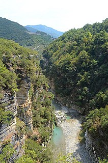
The Osum Gorge is a river gorge in southern Albania, near the town of Çorovodë. The river Osum, which passes through the town of Berat, flows through the canyon.
| | This article about geography terminology is a stub. You can help Wikipedia by expanding it. |