Rosebud also Sicanġu is a census-designated place (CDP) in Todd County, South Dakota, United States. The population was 1,455 at the 2020 census.
Chester is an unincorporated community and census-designated place (CDP) in Lake County, South Dakota, United States. The population was 257 as of the 2020 census. Chester has been assigned the ZIP code of 57016.
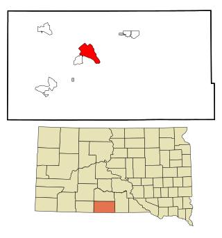
Saint Onge is an unincorporated community and census-designated place (CDP) in Lawrence County, South Dakota, United States. As of the 2020 census, the population was 170.
Winfred is an unincorporated community and census-designated place (CDP) in Lake County, South Dakota, United States, approximately 12 miles (19 km) west of Madison. The population was 38 as of the 2020 census. Winfred has been assigned the ZIP code of 57076.
Shindler is an unincorporated community and census-designated place (CDP) in Lincoln County, South Dakota, United States. The population was 607 at the 2020 census.
Morningside is a census-designated place (CDP) in Beadle County, South Dakota, United States. The population was 70 at the 2020 census.
Lake Poinsett is a census-designated place (CDP) in Hamlin and Brookings counties in South Dakota, United States. The population was 501 at the 2020 census.
Crocker is an unincorporated community and census-designated place (CDP) in Clark County, South Dakota, United States. The population was 19 at the 2020 census.
Brant Lake South is a census-designated place (CDP) in Lake County, South Dakota, United States. The population was 140 at the 2020 census. It was established after the 2010 census.
Prairiewood Village is an unincorporated community and census-designated place (CDP) in Brown County, South Dakota, United States. It was first listed as a CDP prior to the 2020 census. The CDP had a population of 303 at the 2020 census.
Clearfield Colony is a Hutterite colony and census-designated place (CDP) within the Yankton Indian Reservation in Charles Mix County, South Dakota, United States. It was first listed as a CDP prior to the 2020 census. The population of the CDP was 99 at the 2020 census.
Platte Colony is a Hutterite colony and census-designated place (CDP) in Charles Mix County, South Dakota, United States. It was first listed as a CDP prior to the 2020 census. The population of the CDP was 299 at the 2020 census.
Dudley is an unincorporated community and census-designated place (CDP) in Fall River County, South Dakota, United States. The population was 28 at the 2020 census. It was first listed as a CDP prior to the 2020 census.
Boulder Canyon is an unincorporated area and census-designated place (CDP) in Lawrence County, South Dakota, United States. The population was 561 at the 2020 census. It was first listed as a CDP prior to the 2020 census.
Wonderland Homes is an unincorporated, developed "neighborhood" community in Meade County, South Dakota, United States, consisting of numerous homes in subdivisional layout and several small businesses. Its origins are unknown, as is its relationship to other places or real estate development businesses called "Wonderland Homes". It is in the southwest part of Meade county, on the eastern edge of the Black Hills. It is bordered to the southwest by the town of Summerset and to the north by the town of Piedmont, to which towns it is sometimes connected as might be a subdivision. Exit 48 on Interstate 90 is 0.5 miles (1 km) to the west; I-90 leads northwest 17 miles (27 km) to Sturgis, the county seat, and southeast 11 miles (18 km) to Rapid City.
Horse Creek is an unincorporated community and census-designated place (CDP) in Mellette County, South Dakota, United States. It was first listed as a CDP prior to the 2020 census. The population of the CDP was 187 at the 2020 census.
Shannon Colony is a census-designated place (CDP) and Hutterite colony in Miner County, South Dakota, United States. It was first listed as a CDP prior to the 2020 census. The population of the CDP was 1 at the 2020 census.
White Rock Colony is a census-designated place (CDP) and Hutterite colony in Roberts County, South Dakota, United States, partly within the Lake Traverse Indian Reservation. It was first listed as a CDP prior to the 2020 census. The population of the CDP was 0 at the 2020 census.
Clark Colony is a census-designated place (CDP) and Hutterite colony in Spink County, South Dakota, United States. It was first listed as a CDP prior to the 2020 census. The population of the CDP was 92 at the 2020 census.
Bridger is an unincorporated community and census-designated place (CDP) in Ziebach County, South Dakota, United States, within the Cheyenne River Indian Reservation. The population was 48 at the 2020 census. It was first listed as a CDP prior to the 2020 census.


