Spring Creek, South Dakota

Last updated

Spring Creek, South Dakota
CDP
Todd County South Dakota Incorporated and Unincorporated areas Spring Creek Highlighted.svg
Location in Todd County and the state of South Dakota
Coordinates: 43°07′13″N100°59′32″W / 43.12028°N 100.99222°W / 43.12028; -100.99222
Country United States
State South Dakota
Counties Todd
Area
  Total9.3 sq mi (24.1 km2)
  Land9.3 sq mi (24.1 km2)
  Water0 sq mi (0 km2)
Elevation
[1]
2,667 ft (813 m)
Population
 (2020)
  Total236
  Density28.8/sq mi (11.1/km2)
GNIS feature ID2393246 [1]

Spring Creek is a census-designated place (CDP) in Todd County, South Dakota, United States. The population was 236 at the 2020 census. [2]

Contents

Geography

According to the United States Census Bureau, the CDP has a total area of 9.3 square miles (24.1 km2), all land.

Demographics

As of the census [3] of 2000, there were 136 people, 29 households, and 26 families residing in the CDP. The population density was 14.6 people per square mile (5.6/km2). There were 33 housing units at an average density of 3.5/sq mi (1.4/km2). The racial makeup of the CDP was 0.00% White and 100.00% Native American.

There were 29 households, out of which 37.9% had children under the age of 18 living with them, 27.6% were married couples living together, 51.7% had a female householder with no husband present, and 10.3% were non-families. 6.9% of all households were made up of individuals, and none had someone living alone who was 65 years of age or older. The average household size was 4.69 and the average family size was 4.92.

In the CDP, the population was spread out, with 43.4% under the age of 18, 14.7% from 18 to 24, 22.1% from 25 to 44, 14.0% from 45 to 64, and 5.9% who were 65 years of age or older. The median age was 21 years. For every 100 females, there were 97.1 males. For every 100 females age 18 and over, there were 87.8 males.

The median income for a household in the CDP was $28,194, and the median income for a family was $28,194. Males had a median income of $0 versus $21,250 for females. The per capita income for the CDP was $4,045. There were 30.8% of families and 44.8% of the population living below the poverty line, including none under 18 and none of those over 64.

Education

The CDP is served by Todd County School District 66-1.

Related Research Articles

Birch Creek is a census-designated place (CDP) in Yukon-Koyukuk Census Area, Alaska, United States. The population was 33 at the 2010 census, up from 28 in 2000.

<span class="mw-page-title-main">Wheatland, North Dakota</span> Census-designated place in North Dakota, United States

Wheatland is a census-designated place (CDP) in Cass County, North Dakota, United States. The population was 68 at the 2010 census.

Bull Hollow is an unincorporated community and census-designated place (CDP) in Delaware County, Oklahoma, United States. The population was 67 at the 2010 census.

<span class="mw-page-title-main">Snake Creek, Oklahoma</span> CDP in Oklahoma, United States

Snake Creek is a census-designated place (CDP) in Mayes County, Oklahoma, United States. The population was 255 at the 2020 census.

<span class="mw-page-title-main">Sandy Ridge, Pennsylvania</span> Census-designated place in Pennsylvania, United States

Sandy Ridge is an unincorporated community and census-designated place (CDP) in Centre County, Pennsylvania, United States. It is part of the State College, Pennsylvania Metropolitan Statistical Area. The population was 407 at the 2010 census.

<span class="mw-page-title-main">Aurora Center, South Dakota</span> CDP in South Dakota, United States

Aurora Center is a census-designated place (CDP) in Aurora County, South Dakota, United States. The population was 22 at the 2020 census.

<span class="mw-page-title-main">Green Grass, South Dakota</span> CDP in South Dakota, United States

Green Grass is a census-designated place (CDP) in Dewey County, South Dakota, United States. The population was 21 at the 2020 census.

<span class="mw-page-title-main">Whitehorse, South Dakota</span> CDP in South Dakota, United States

Whitehorse is a census-designated place (CDP) in Dewey County, South Dakota, United States. The population was 106 at the 2020 census.

<span class="mw-page-title-main">Milltown, South Dakota</span> CDP in South Dakota, United States

Milltown is a census-designated place (CDP) in Hutchinson County, South Dakota, United States. The population was 8 at the 2020 census.

<span class="mw-page-title-main">Roswell, South Dakota</span> Census-designated place in South Dakota, United States

Roswell is a CDP in Miner County, South Dakota, United States. The population was 8 at the 2020 census. It disincorporated as a town in 2012.

<span class="mw-page-title-main">Colonial Pine Hills, South Dakota</span> CDP in South Dakota, United States

Colonial Pine Hills is a census-designated place (CDP) and unincorporated community in Pennington County, South Dakota, United States. The population was 1,903 at the 2020 census.

<span class="mw-page-title-main">Green Valley, South Dakota</span> CDP in South Dakota, United States

Green Valley is a census-designated place (CDP) and unincorporated community in Pennington County, South Dakota, United States. The population was 1,051 at the 2020 census.

<span class="mw-page-title-main">Wounded Knee, South Dakota</span> CDP in South Dakota, United States

Wounded Knee is a census-designated place (CDP) on the Pine Ridge Indian Reservation in Oglala Lakota County, South Dakota, United States. The population was 364 at the 2020 census.

<span class="mw-page-title-main">Antelope, South Dakota</span> CDP in South Dakota, United States

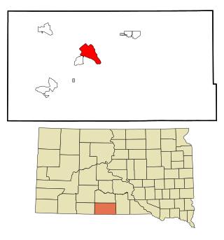
Antelope is a census-designated place (CDP) in Todd County, South Dakota, United States. The population was 830 at the 2020 census.

<span class="mw-page-title-main">Rosebud, South Dakota</span> CDP in South Dakota, United States

Rosebud also Sicanġu is a census-designated place (CDP) in Todd County, South Dakota, United States. The population was 1,455 at the 2020 census.

<span class="mw-page-title-main">Two Strike, South Dakota</span> CDP in South Dakota, United States

Two Strike is a census-designated place (CDP) in Todd County, South Dakota, United States, named after Brulé, Lakota chief Two Strike who lived at that location for a period of time. The population was 282 at the 2020 census.

<span class="mw-page-title-main">White Horse, South Dakota</span> CDP in South Dakota, United States

White Horse also Šuŋgská oyáŋke is a census-designated place (CDP) in Todd County, South Dakota, United States. The population was 234 at the 2020 census.

<span class="mw-page-title-main">Geronimo, Texas</span> Census-designated place in Texas, United States

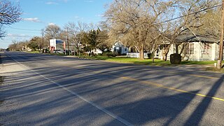
Geronimo is an unincorporated community and census-designated place (CDP) in Guadalupe County, Texas, United States. The population was 1,032 at the 2010 census, up from 619 at the 2000 census. It is part of the San Antonio Metropolitan Statistical Area.

<span class="mw-page-title-main">Northwest Stanwood, Washington</span> CDP in Washington, United States

Northwest Stanwood is a census-designated place (CDP) in Snohomish County, Washington, United States. The population was 149 at the 2010 census. The CDP was known as North Stanwood prior to the 2010 census, and it included area that is now part of the city of Stanwood.

<span class="mw-page-title-main">Owl Creek, Wyoming</span> CDP in Wyoming, United States

Owl Creek is a (CDP) in Hot Springs County, Wyoming, United States. The population was five at the 2010 Census.

References

  1. 1 2 U.S. Geological Survey Geographic Names Information System: Spring Creek, South Dakota
  2. "U.S. Census Bureau: Spring Creek, South Dakota". www.census.gov. United States Census Bureau. Retrieved December 23, 2021.
  3. "U.S. Census website". United States Census Bureau . Retrieved January 31, 2008.