Siloam, Georgia

Last updated

Siloam, Georgia
Downtown Siloam, Georgia May 2017.jpg
Downtown Siloam
Greene County Georgia Incorporated and Unincorporated areas Siloam Highlighted.svg
Location in Greene County and the state of Georgia
Coordinates: 33°32′8″N83°4′50″W / 33.53556°N 83.08056°W / 33.53556; -83.08056
Country United States
State Georgia
County Greene
Area
[1]
  Total1.24 sq mi (3.22 km2)
  Land1.21 sq mi (3.14 km2)
  Water0.03 sq mi (0.08 km2)
Elevation
702 ft (214 m)
Population
 (2020)
  Total194
  Density159.80/sq mi (61.71/km2)
Time zone UTC-5 (Eastern (EST))
  Summer (DST) UTC-4 (EDT)
ZIP code
30665
Area code 706
FIPS code 13-70932 [2]
GNIS feature ID0356535 [3]

Siloam is a town in Greene County, Georgia, United States. The population was 282 at the 2010 census, [4] down from 331 in 2000.

Contents

History

Siloam was originally called "Smyrna", and under the latter name permanent settlement was first made in the 1840s. [5] A post office called Siloam was established in 1871. [6] The present name is after the ancient Siloam tunnel, a place mentioned in the Hebrew Bible. [7]

Geography

Siloam is located in eastern Greene County at 33°32′8″N83°4′50″W / 33.53556°N 83.08056°W / 33.53556; -83.08056 (33.535691, -83.080443). [8] Georgia State Route 15 passes through the town as Main Street, leading northwest 7 miles (11 km) to Greensboro, the county seat, and south 5.5 miles (8.9 km) to White Plains. State Route 77 leads north from the center of town 6 miles (10 km) to Union Point. Interstate 20 passes through the northern side of town, with access from Exit 138 (State Route 77). I-20 leads east 64 miles (103 km) to Augusta and west 80 miles (130 km) to Atlanta.

According to the United States Census Bureau, Siloam has a total area of 1.2 square miles (3.2 km2), of which 0.031 square miles (0.08 km2), or 2.38%, is water. [4]

Demographics

Historical population
CensusPop.Note
1920 243
1930 26910.7%
1940 31818.2%
1950 3241.9%
1960 321−0.9%
1970 319−0.6%
1980 44639.8%
1990 329−26.2%
2000 3310.6%
2010 282−14.8%
2020 194−31.2%
U.S. Decennial Census [9]
1850-1870 [10] 1870-1880 [11]
1890-1910 [12] 1920-1930 [13]
1940 [14] 1950 [15] 1960 [16]
1970 [17] 1980 [18] 1990 [19]
2000 [20] 2010 [21] 2020 [22]
Siloam, Georgia – Racial and ethnic composition
Note: the US Census treats Hispanic/Latino as an ethnic category. This table excludes Latinos from the racial categories and assigns them to a separate category. Hispanics/Latinos may be of any race.
Race / Ethnicity (NH = Non-Hispanic)Pop 2000 [23] Pop 2010 [21] Pop 2020 [22] % 2000% 20102020
White alone (NH)79756623.87%26.60%34.02%
Black or African American alone (NH)24219911073.11%70.57%56.70%
Native American or Alaska Native alone (NH)0000.00%0.00%0.00%
Asian alone (NH)2310.60%1.06%0.52%
Pacific Islander alone (NH)0000.00%0.00%0.00%
Some Other Race alone (NH)0000.00%0.00%0.00%
Mixed Race or Multi-Racial (NH)0400.00%1.42%0.00%
Hispanic or Latino (any race)81172.42%0.35%8.76%
Total331282194100.00%100.00%100.00%

As of the census [2] of 2000, there were 331 people, 121 households, and 78 families residing in the town. The population density was 269.8 inhabitants per square mile (104.2/km2). There were 144 housing units at an average density of 117.4 per square mile (45.3/km2). The racial makeup of the town was 25.38% White, 73.11% African American, 0.60% Asian, 0.91% from other races. Hispanic or Latino of any race were 2.42% of the population.

There were 121 households, out of which 25.6% had children under the age of 18 living with them, 28.1% were married couples living together, 29.8% had a female householder with no husband present, and 35.5% were non-families. 28.9% of all households were made up of individuals, and 17.4% had someone living alone who was 65 years of age or older. The average household size was 2.74 and the average family size was 3.38.

In the town, the population was spread out, with 27.2% under the age of 18, 11.2% from 18 to 24, 22.1% from 25 to 44, 23.6% from 45 to 64, and 16.0% who were 65 years of age or older. The median age was 38 years. For every 100 females, there were 79.9 males. For every 100 females age 18 and over, there were 79.9 males.

The median income for a household in the town was $23,125, and the median income for a family was $24,792. Males had a median income of $21,250 versus $19,821 for females.

Education

Related Research Articles

<span class="mw-page-title-main">Clay County, Georgia</span> County in Georgia, United States

Clay County is a county located in the southwestern part of the U.S. state of Georgia. As of the 2020 census, the population was 2,848, making it the fourth-least populous county in Georgia. The county seat is Fort Gaines.
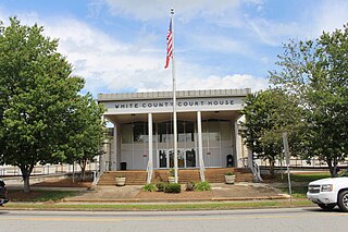
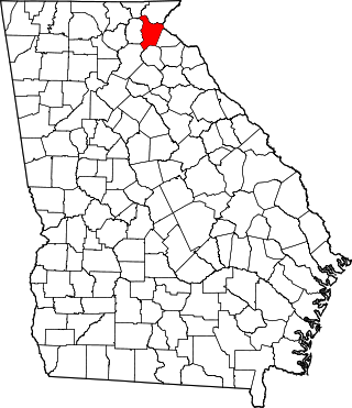
<span class="mw-page-title-main">White County, Georgia</span> County in Georgia, United States

White County is a county located in the northeastern part of the U.S. state of Georgia. As of the 2020 census, the population was 28,003. The county seat is Cleveland. The county was created on December 22, 1857, formerly a part of Habersham County and most likely was named for Newton County Representative David T. White, who helped a Habersham representative successfully attain passage of an act creating the new county.
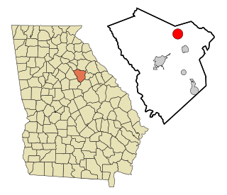
<span class="mw-page-title-main">Catoosa County, Georgia</span> County in Georgia, United States

Catoosa County is a county located in the northwestern part of the U.S. state of Georgia. As of the 2020 census, the population was 67,872. The county seat is Ringgold. The county was created on December 5, 1853. The meaning of the Cherokee language name "Catoosa" is obscure: "Catoosa" may come from the Cherokee words gatusi or gatu'gitse.

<span class="mw-page-title-main">Newbern, Alabama</span> Town in Alabama, United States

Newbern is a town in Hale County, Alabama, United States. As of the 2020 census, the population of the town was 133.

<span class="mw-page-title-main">Decatur, Arkansas</span> City in Arkansas, United States

Decatur is a city, in Benton County, Arkansas, United States. The population was 1,773 at the 2020 census. It is part of the Northwest Arkansas region. This town is named after Commodore Stephen Decatur, Jr.

<span class="mw-page-title-main">Jennings, Florida</span> Town in the state of Florida, United States

Jennings is a town in Hamilton County, Florida, United States. The population was 749 at the 2020 census, down from 878 at the 2010 census.

<span class="mw-page-title-main">Cottondale, Florida</span> City in Florida, United States

Cottondale is a city in Jackson County, Florida, United States. It is part of the Florida Panhandle and North Florida. The population was 848 at the 2020 census, down from 933 at the 2010 census.

<span class="mw-page-title-main">Greenville, Florida</span> Town in the state of Florida, United States

Greenville is a town in Madison County, Florida, United States. The population was 746 at the 2020 census, down from 843 at the 2010 census.

<span class="mw-page-title-main">Lee, Florida</span> Town in the state of Florida, United States

Lee is a town in Madison County, Florida, United States. The Town of Lee is part of the Florida Panhandle in North Florida. The population was 375 at the 2020 census.

<span class="mw-page-title-main">Princeton, Florida</span> Census-designated place in Florida

Princeton is a census-designated place (CDP) and unincorporated community in Miami-Dade County, Florida, United States. It is part of the Miami metropolitan area of South Florida. The population was 39,208 at the 2020 census, up from 22,038 at the 2010 census.

<span class="mw-page-title-main">Vinings, Georgia</span> Place in Georgia, United States

Vinings is an unincorporated community and census-designated place (CDP) in Cobb County, Georgia, United States that runs along the Chattahoochee River bank across from Buckhead. As of the 2020 census, the CDP had a total population of 12,581. Located next to the affluent Paces section of Buckhead in northwest Atlanta, Vinings is known for its historic sites, shopping districts, proximity to local freeways and The Battery, and nearby nature areas. The United States Postal Service assigns "Atlanta" to the ZIP Code (30339) that includes Vinings.

<span class="mw-page-title-main">Morganton, Georgia</span> City in Georgia, United States

Morganton is a city in Fannin County, Georgia, United States. The population was 285 at the 2020 census.

<span class="mw-page-title-main">Union Point, Georgia</span> City in Georgia, United States

Union Point is a city in Greene County, Georgia, United States. As of the 2020 census, the city population was 1,597.

<span class="mw-page-title-main">White Plains, Georgia</span> City in Georgia, United States

White Plains is a city in Greene County, Georgia, United States. The population was 284 at the 2010 census.

<span class="mw-page-title-main">Woodville, Georgia</span> City in Georgia, United States

Woodville is a city in Greene County, Georgia, United States. The population was 321 at the 2010 census, down from 400 at the 2000 census.

<span class="mw-page-title-main">Talmo, Georgia</span> Town in Georgia, United States

Talmo is a town in Jackson County, Georgia, United States. The population was 257 at the 2020 census.

<span class="mw-page-title-main">Bostwick, Georgia</span> City in Georgia, United States

Bostwick is a city in Morgan County, Georgia, United States. As of the 2020 census, the city had a population of 378.

<span class="mw-page-title-main">Buckhead, Morgan County, Georgia</span> Town in Georgia, United States

Buckhead is a town in Morgan County, Georgia, United States. As of the 2020 census, the town had a population of 194.

<span class="mw-page-title-main">Plains, Georgia</span> City in Georgia, United States

Plains is a city in Sumter County, Georgia, United States. The population was 573 at the 2020 census and it is a part of the Americus Micropolitan Statistical Area. It is best known as the birthplace of Jimmy Carter and his wife Rosalynn, who were the president and first lady of the United States respectively from 1977 to 1981. They lived in Plains both before and after their time in the White House.

<span class="mw-page-title-main">State Line, Mississippi</span> Town in Mississippi, United States

State Line is a town in Greene and Wayne counties, Mississippi, in the United States. The population was 452 at the 2020 census.

References

  1. "2020 U.S. Gazetteer Files". United States Census Bureau. Retrieved December 18, 2021.
  2. 1 2 "U.S. Census website". United States Census Bureau . Retrieved January 31, 2008.
  3. "US Board on Geographic Names". United States Geological Survey. October 25, 2007. Retrieved January 31, 2008.
  4. 1 2 "Geographic Identifiers: 2010 Demographic Profile Data (G001): Siloam town, Georgia". American Factfinder. U.S. Census Bureau. Retrieved November 29, 2016.[ dead link ]
  5. "Greene County". New Georgia Encyclopedia. Retrieved June 5, 2019.
  6. "Post Offices". Jim Forte Postal History. Retrieved June 4, 2019.
  7. Krakow, Kenneth K. (1975). Georgia Place-Names: Their History and Origins (PDF). Macon, GA: Winship Press. p. 205. ISBN   0-915430-00-2.
  8. "US Gazetteer files: 2010, 2000, and 1990". United States Census Bureau. February 12, 2011. Retrieved April 23, 2011.
  9. "Decennial Census of Population and Housing by Decade". US Census Bureau.
  10. "1870 Census of Population - Georgia - Population of Civil Divisions less than Counties" (PDF). US Census Bureau . 1870.
  11. "1880 Census of Population - Georgia - Population of Civil Divisions less than Counties" (PDF). US Census Bureau . 1880.
  12. "1910 Census of Population - Georgia" (PDF). US Census Bureau . 1930.
  13. "1930 Census of Population - Georgia" (PDF). US Census Bureau . 1930. pp. 251–256.
  14. "1940 Census of Population - Georgia" (PDF). US Census Bureau . 1940.
  15. "1950 Census of Population - Georgia" (PDF). US Census Bureau . 1980.
  16. "1960 Census of Population - Population of County Subdivisions - Georgia" (PDF). US Census Bureau . 1960.
  17. "1970 Census of Population - Population of County Subdivisions - Georgia" (PDF). US Census Bureau . 1970.
  18. "1980 Census of Population - Number of Inhabitants - Georgia" (PDF). US Census Bureau . 1980.
  19. "1990 Census of Population - Summary Social, Economic, and Housing Characteristics - Georgia" (PDF). US Census Bureau . 1990.
  20. "2000 Census of Population - General Population Characteristics - Georgia" (PDF). US Census Bureau . 2000.
  21. 1 2 "P2 Hispanic or Latino, and Not Hispanic or Latino by Race – 2010: DEC Redistricting Data (PL 94-171) – Siloam town, Georgia". United States Census Bureau .
  22. 1 2 "P2 Hispanic or Latino, and Not Hispanic or Latino by Race – 2020: DEC Redistricting Data (PL 94-171) – Siloam town, Georgia". United States Census Bureau .
  23. "P004 Hispanic or Latino, and Not Hispanic or Latino by Race – 2000: DEC Summary File 1 – Siloam town, Georgia". United States Census Bureau .