Woodville, Georgia

Last updated

Woodville, Georgia
Greene County Georgia Incorporated and Unincorporated areas Woodville Highlighted.svg
Location in Greene County and the state of Georgia
Coordinates: 33°40′41″N83°6′28″W / 33.67806°N 83.10778°W / 33.67806; -83.10778
Country United States
State Georgia
County Greene
Area
[1]
  Total4.98 sq mi (12.90 km2)
  Land4.96 sq mi (12.85 km2)
  Water0.02 sq mi (0.04 km2)
Elevation
702 ft (214 m)
Population
 (2020)
  Total264
  Density53.19/sq mi (20.54/km2)
Time zone UTC-5 (Eastern (EST))
  Summer (DST) UTC-4 (EDT)
FIPS code 13-84260 [2]
GNIS feature ID0356651 [3]

Woodville is a city in Greene County, Georgia, United States. The population was 321 at the 2010 census, [4] down from 400 at the 2000 census.

Contents

History

According to tradition Woodville was so named from the fact it was a shipping point of wood. [5] The Georgia General Assembly incorporated Woodville as a city in 1911. [6]

Geography

Woodville is in northeastern Greene County along Georgia State Route 77 (Dogwood Road), 4.5 miles (7.2 km) north of Union Point and 8 miles (13 km) south of Maxeys. Greensboro, the Greene County seat, is 9 miles (14 km) to the southwest.

According to the United States Census Bureau, Woodville has a total area of 4.9 square miles (12.7 km2), of which 0.02 square miles (0.04 km2), or 0.33%, is water. [4]

Demographics

Historical population
CensusPop.Note
1920 458
1930 332−27.5%
1940 45838.0%
1950 4845.7%
1960 372−23.1%
1970 3791.9%
1980 45520.1%
1990 415−8.8%
2000 400−3.6%
2010 321−19.7%
2020 264−17.8%
U.S. Decennial Census [7]
1850-1870 [8] 1870-1880 [9]
1890-1910 [10] 1920-1930 [11]
1940 [12] 1950 [13] 1960 [14]
1970 [15] 1980 [16] 1990 [17]
2000 [18] 2010 [19] 2020 [20]
Woodville, Georgia – Racial and ethnic composition
Note: the US Census treats Hispanic/Latino as an ethnic category. This table excludes Latinos from the racial categories and assigns them to a separate category. Hispanics/Latinos may be of any race.
Race / Ethnicity (NH = Non-Hispanic)Pop 2000 [21] Pop 2010 [19] Pop 2020 [20] % 2000% 2010% 2020
White alone (NH)95929535.98%28.66%35.98%
Black or African American alone (NH)16421916462.12%68.22%62.12%
Native American or Alaska Native alone (NH)0000.00%0.00%0.00%
Asian alone (NH)2120.76%0.31%0.76%
Pacific Islander alone (NH)0000.00%0.00%0.00%
Some Other Race alone (NH)0300.00%0.93%0.00%
Mixed Race or Multi-Racial (NH)0200.00%0.62%0.00%
Hispanic or Latino (any race)3431.14%1.25%1.14%
Total432321264100.00%100.00%100.00%

As of the census [2] of 2000, there were 400 people, 136 households, and 99 families residing in the city. The population density was 81.3 inhabitants per square mile (31.4/km2). There were 147 housing units at an average density of 29.9 per square mile (11.5/km2). The racial makeup of the city was 29.50% White, 69.50% African American, 0.75% Native American and 0.25% Asian. Hispanic or Latino of any race were 1.50% of the population.

There were 136 households, out of which 29.4% had children under the age of 18 living with them, 41.9% were married couples living together, 26.5% had a female householder with no husband present, and 27.2% were non-families. 22.8% of all households were made up of individuals, and 11.8% had someone living alone who was 65 years of age or older. The average household size was 2.94 and the average family size was 3.43.

In the city, the population was spread out, with 30.3% under the age of 18, 7.8% from 18 to 24, 23.8% from 25 to 44, 27.0% from 45 to 64, and 11.3% who were 65 years of age or older. The median age was 36 years. For every 100 females, there were 86.9 males. For every 100 females age 18 and over, there were 88.5 males.

The median income for a household in the city was $31,667, and the median income for a family was $34,219. Males had a median income of $25,568 versus $22,500 for females. The per capita income for the city was $14,550. About 19.4% of families and 28.1% of the population were below the poverty line, including 40.6% of those under age 18 and 9.3% of those age 65 or over.

Notable person

Woodville was home to Major Robert McWhorter (CSA) who represented Greene County in the Georgia General Assembly for most of the period 1847–1884. McWhorter is noted as being the first Republican Speaker of the Georgia House of Representatives (1868-1870) under the Reconstruction era government. McWhorter is buried in Woodville Cemetery.

Related Research Articles

<span class="mw-page-title-main">Clay County, Georgia</span> County in Georgia, United States

Clay County is a county located in the southwestern part of the U.S. state of Georgia. As of the 2020 census, the population was 2,848, making it the fourth-least populous county in Georgia. The county seat is Fort Gaines.

<span class="mw-page-title-main">Chambers County, Alabama</span> County in Alabama, United States

Chambers County is a county located in the east central portion of the U.S. state of Alabama. As of the 2020 census the population was 34,772. Its county seat is LaFayette. Its largest city is Valley. Its name is in honor of Henry H. Chambers, who served as a United States Senator from Alabama.

<span class="mw-page-title-main">Cleburne County, Alabama</span> County in Alabama, United States

Cleburne County is a county located in the east central portion of the U.S. state of Alabama. As of the 2020 census, the population was 15,056. Its county seat is Heflin. Its name is in honor of Patrick R. Cleburne of Arkansas who rose to the rank of major general in the Confederate States Army. The eastern side of the county borders the state of Georgia.

<span class="mw-page-title-main">Tyler County, Texas</span> County in Texas, United States

Tyler County is a county located in the U.S. state of Texas. It is in East Texas and its seat is Woodville.

<span class="mw-page-title-main">Whitfield County, Georgia</span> County in Georgia, United States

Whitfield County is a county located in the northwestern part of the U.S. state of Georgia. As of the 2020 census shows a population of 102,864. The county seat is Dalton. The county was created on December 30, 1851, and named after George Whitefield, Methodist evangelist. The "e" was omitted to reflect the pronunciation of his name.

<span class="mw-page-title-main">Walker County, Georgia</span> County in Georgia, United States

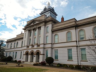
Walker County is a county located in the northwestern part of the U.S. state of Georgia. As of the 2020 census, the population was 67,654, down from 68,756 in 2010. The county seat is LaFayette. The county was created on December 18, 1833, from land formerly belonging to the Cherokee Indian Nation.

<span class="mw-page-title-main">Catoosa County, Georgia</span> County in Georgia, United States

Catoosa County is a county located in the northwestern part of the U.S. state of Georgia. As of the 2020 census, the population was 67,872. The county seat is Ringgold. The county was created on December 5, 1853. The meaning of the Cherokee language name "Catoosa" is obscure: "Catoosa" may come from the Cherokee words gatusi or gatu'gitse.

<span class="mw-page-title-main">Burke County, Georgia</span> County in Georgia, United States

Burke County is a county located along the eastern border of the U.S. state of Georgia in the Piedmont. As of the 2020 census, the population was 24,596. The county seat is Waynesboro. Burke County is part of the Augusta-Richmond County, GA-SC metropolitan statistical area.

<span class="mw-page-title-main">Lakeview, Georgia</span> Place in Georgia, United States

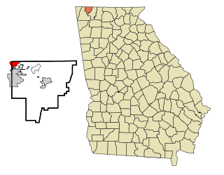
Lakeview is an unincorporated community and census-designated place (CDP) in Catoosa and Walker counties in the U.S. state of Georgia. The population was 4,820 at the 2000 census and 4,777 at the 2020 census. It is part of the Chattanooga, TN–GA Metropolitan Statistical Area.

<span class="mw-page-title-main">Forest Park, Georgia</span> City in Georgia, United States

Forest Park is a city in Clayton County, Georgia, United States. It is located approximately nine miles (14 km) south of Atlanta and is part of the Atlanta–Sandy Springs–Marietta Metropolitan Statistical Area. As of the 2020 census, the city had a population of 19,932.

<span class="mw-page-title-main">Candler-McAfee, Georgia</span> Place in Georgia, United States

Candler-McAfee is an unincorporated community and census-designated place (CDP) in DeKalb County, Georgia, United States. It is located east of Atlanta approximately 10 miles (16 km) east of Downtown Atlanta and to the south of Decatur, Georgia The population was 23,025 at the 2010 census.

<span class="mw-page-title-main">Lindale, Georgia</span> Place in Georgia, United States

Lindale is an unincorporated community and census-designated place (CDP) in Floyd County, Georgia, United States. It is part of the Rome, Georgia Metropolitan Statistical Area. The population was 4,191 at the 2010 census.

<span class="mw-page-title-main">Union City, Georgia</span> City in Georgia, United States

Union City is a city in Fulton County, Georgia, United States. The population was 26,830 at the 2020 census.

<span class="mw-page-title-main">Siloam, Georgia</span> Town in Georgia, United States

Siloam is a town in Greene County, Georgia, United States. The population was 282 at the 2010 census, down from 331 in 2000.

<span class="mw-page-title-main">Union Point, Georgia</span> City in Georgia, United States

Union Point is a city in Greene County, Georgia, United States. As of the 2020 census, the city population was 1,597.

<span class="mw-page-title-main">White Plains, Georgia</span> City in Georgia, United States

White Plains is a city in Greene County, Georgia, United States. The population was 284 at the 2010 census.

<span class="mw-page-title-main">Mountain Park, Gwinnett County, Georgia</span> Place in Georgia, United States

Mountain Park is an unincorporated community and census-designated place (CDP) in Gwinnett County, Georgia, United States. The population was 11,554 at the 2010 census. The older name for the area is Trickum, which is reflected in Five Forks-Trickum Road which bisects the community. The older community was centered on Five Forks and Rockbridge Roads.

<span class="mw-page-title-main">Aragon, Georgia</span> City in Georgia, United States

Aragon is a city in Polk County, Georgia, United States. As of the 2020 census, the city had a population of 1,440.

<span class="mw-page-title-main">Varnell, Georgia</span> City in Georgia, United States

Varnell is a city in Whitfield County, Georgia, United States. It is part of the Dalton, Georgia Metropolitan Statistical Area. The population was 2,179 at the 2020 census.

<span class="mw-page-title-main">Woodville, Texas</span> Town in Texas, United States

Woodville is a town and county seat of Tyler County, Texas, United States. The town is intersected by three U.S. highways: U.S. Highway 69, U.S. Highway 190, and U.S. Highway 287. The population was 2,403 at the 2020 census. It is the county seat of Tyler County. The town was named after George Tyler Wood, governor of Texas from 1847 to 1849.

References

  1. "2020 U.S. Gazetteer Files". United States Census Bureau. Retrieved December 18, 2021.
  2. 1 2 "U.S. Census website". United States Census Bureau . Retrieved January 31, 2008.
  3. "US Board on Geographic Names". United States Geological Survey. October 25, 2007. Retrieved January 31, 2008.
  4. 1 2 "Geographic Identifiers: 2010 Demographic Profile Data (G001): Woodville city, Georgia". American Factfinder. U.S. Census Bureau. Retrieved November 29, 2016.[ dead link ]
  5. Krakow, Kenneth K. (1975). Georgia Place-Names: Their History and Origins (PDF). Macon, GA: Winship Press. p. 257. ISBN   0-915430-00-2.
  6. Acts and Resolutions of the General Assembly of the State of Georgia. State printer. 1911. p. 1639.
  7. "Decennial Census of Population and Housing by Decade". US Census Bureau.
  8. "1870 Census of Population - Georgia - Population of Civil Divisions less than Counties" (PDF). US Census Bureau . 1870.
  9. "1880 Census of Population - Georgia - Population of Civil Divisions less than Counties" (PDF). US Census Bureau . 1880.
  10. "1910 Census of Population - Georgia" (PDF). US Census Bureau . 1930.
  11. "1930 Census of Population - Georgia" (PDF). US Census Bureau . 1930. pp. 251–256.
  12. "1940 Census of Population - Georgia" (PDF). US Census Bureau . 1940.
  13. "1950 Census of Population - Georgia" (PDF). US Census Bureau . 1980.
  14. "1960 Census of Population - Population of County Subdivisions - Georgia" (PDF). US Census Bureau . 1960.
  15. "1970 Census of Population - Population of County Subdivisions - Georgia" (PDF). US Census Bureau . 1970.
  16. "1980 Census of Population - Number of Inhabitants - Georgia" (PDF). US Census Bureau . 1980.
  17. "1990 Census of Population - Summary Social, Economic, and Housing Characteristics - Georgia" (PDF). US Census Bureau . 1990.
  18. "2000 Census of Population - General Population Characteristics - Georgia" (PDF). US Census Bureau . 2000.
  19. 1 2 "P2 Hispanic or Latino, and Not Hispanic or Latino by Race – 2010: DEC Redistricting Data (PL 94-171) – Woodville city, Georgia". United States Census Bureau .
  20. 1 2 "P2 Hispanic or Latino, and Not Hispanic or Latino by Race – 2010: DEC Redistricting Data (PL 94-171) – Woodville city, Georgia". United States Census Bureau .
  21. "P004 Hispanic or Latino, and Not Hispanic or Latino by Race – 2000: DEC Summary File 1 – Woodville city, Georgia, Georgia". United States Census Bureau .