Singac, New Jersey

Last updated

Singac, New Jersey
Little falls twp nj.png
Map of Little Falls in Passaic County; Singac is located in the western end of Little Falls. Inset: Location of Passaic County highlighted in the State of New Jersey.
Census Bureau map of Little Falls, New Jersey.png
Census Bureau map of Little Falls, New Jersey, in which Singac is located at its western end
Location map of Passaic County, New Jersey.svg
Red pog.svg
Singac
Location in Passaic County
USA New Jersey relief location map.svg
Red pog.svg
Singac
Location in New Jersey
Usa edcp relief location map.png
Red pog.svg
Singac
Location in the United States
Coordinates: 40°53′03″N74°14′37″W / 40.884254°N 74.243539°W / 40.884254; -74.243539 [1] [2]
Country Flag of the United States.svg  United States
State Flag of New Jersey.svg  New Jersey
County Passaic
Township Little Falls
Area
[3]
  Total0.49 sq mi (1.27 km2)
  Land0.46 sq mi (1.19 km2)
  Water0.03 sq mi (0.08 km2)  6.34%
Elevation
[4]
167 ft (51 m)
Population
 (2020) [5]
  Total3,602
  Density7,847.49/sq mi (3,027.39/km2)
Time zone UTC−05:00 (Eastern (EST))
  Summer (DST) UTC−04:00 (Eastern (EDT))
ZIP Code
07424 [6]
Area code(s) 862/973
FIPS code 34-67770 [1] [7] [8]
GNIS feature ID02584027 [1] [9] [10]

Singac (pronounced SING-ack [11] ) is an unincorporated community and census-designated place (CDP) located within Little Falls, in Passaic County, in the U.S. state of New Jersey. [12] [13] [14] [15] As of the 2010 United States Census, the CDP's population was 3,618. [16]

Contents

The name Singac is believed to be an interpretation of the Lenape words meaning "backbone of mountain" [17] [18] or that it may originate from the Lenape term schinghacki meaning "flat country" or from schingask meaning "boggy meadow", which alludes to how the area floods after a storm. [19]

Geography

According to the United States Census Bureau, the CDP had a total area of 0.498 square miles (1.289 km2), including 0.466 square miles (1.207 km2) of land and 0.032 square miles (0.082 km2) of water (6.34%). [1] [2]

Singac is a neighborhood in the western end of Little Falls. It is bounded to the north by the Passaic River. New Jersey Route 23, known as the Newark-Pompton Turnpike or Pompton Avenue, runs north-south through the community.

Economy

Mountain View Diners Company operated from 1939 to 1957, manufacturing prefabricated diners that were shipped nationwide. [20]

Demographics

Historical population
CensusPop.Note
2020 3,602
U.S. Decennial Census [21] [5]

The 2010 United States census counted 3,618 people, 1,477 households, and 920 families in the CDP. The population density was 7,763.6 per square mile (2,997.5/km2). There were 1,545 housing units at an average density of 3,315.3 per square mile (1,280.0/km2). The racial makeup was 88.00% (3,184) White, 1.35% (49) Black or African American, 0.14% (5) Native American, 5.80% (210) Asian, 0.00% (0) Pacific Islander, 2.65% (96) from other races, and 2.05% (74) from two or more races. Hispanic or Latino of any race were 12.82% (464) of the population. [16]

Of the 1,477 households, 25.5% had children under the age of 18; 45.6% were married couples living together; 11.7% had a female householder with no husband present and 37.7% were non-families. Of all households, 31.5% were made up of individuals and 9.9% had someone living alone who was 65 years of age or older. The average household size was 2.45 and the average family size was 3.16. [16]

19.5% of the population were under the age of 18, 7.7% from 18 to 24, 30.6% from 25 to 44, 27.7% from 45 to 64, and 14.5% who were 65 years of age or older. The median age was 40.1 years. For every 100 females, the population had 94.5 males. For every 100 females ages 18 and older there were 90.5 males. [16]

Related Research Articles

<span class="mw-page-title-main">Country Lake Estates, New Jersey</span> Populated place in Burlington County, New Jersey, US

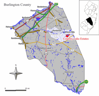
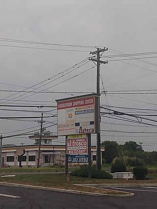
Country Lake Estates is an unincorporated community and census-designated place (CDP) located within Pemberton Township, in Burlington County, in the U.S. state of New Jersey. As of the 2010 United States Census, the CDP's population was 3,943.

<span class="mw-page-title-main">Ramblewood, New Jersey</span> Populated place in Burlington County, New Jersey, US

Ramblewood is an unincorporated community and census-designated place (CDP) located within Mount Laurel Township in Burlington County, in the U.S. state of New Jersey. As of the 2010 United States Census, the CDP's population was 5,907.

<span class="mw-page-title-main">Concordia, New Jersey</span> Populated place in Middlesex County, New Jersey, US

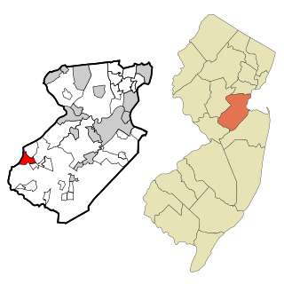
Concordia is an unincorporated community and census-designated place (CDP) located within Monroe Township, in Middlesex County, in the U.S. state of New Jersey. The CDP is oriented around the age restricted gated community of Concordia. As of the 2010 United States Census, the CDP's population was 3,092.

<span class="mw-page-title-main">Heathcote, New Jersey</span> Populated place in Middlesex County, New Jersey, US

Heathcote is an unincorporated community and census-designated place (CDP) located within South Brunswick, in Middlesex County, in the U.S. state of New Jersey. As of the 2010 United States Census, the CDP's population was 5,821.

<span class="mw-page-title-main">Old Bridge (CDP), New Jersey</span> Populated place in Middlesex County, New Jersey, US

Old Bridge is a census-designated place (CDP) located in Old Bridge Township, in Middlesex County, in the U.S. state of New Jersey. As of the 2010 United States Census, the CDP's population was 23,753. Despite the similarity in the name of the CDP and the township, the two are not one and the same, as had been the case for most paired Township / CDP combinations prior to the 2010 Census, in which the CDP was coextensive with a township of the same name.

<span class="mw-page-title-main">East Freehold, New Jersey</span> Populated place in Monmouth County, New Jersey, US

East Freehold is an unincorporated community and census-designated place (CDP) located within Freehold Township, in Monmouth County, in the U.S. state of New Jersey. As of the 2010 United States Census, the CDP's population was 4,894.

<span class="mw-page-title-main">Barnegat (CDP), New Jersey</span> Populated place in Ocean County, New Jersey, US

Barnegat is an unincorporated community and census-designated place (CDP) located within Barnegat Township, in Ocean County, in the U.S. state of New Jersey. As of the 2010 United States census, the CDP's population was 2,817.

<span class="mw-page-title-main">Cedar Glen Lakes, New Jersey</span> Populated place in Ocean County, New Jersey, US

Cedar Glen Lakes is an unincorporated community and census-designated place (CDP) located within Manchester Township, in Ocean County, in the U.S. state of New Jersey. As of the 2010 United States Census, the CDP's population was 1,421.

<span class="mw-page-title-main">Leisure Knoll, New Jersey</span> Populated place in Ocean County, New Jersey, US

Leisure Knoll is an unincorporated community and census-designated place (CDP) located within Manchester Township, in Ocean County, in the U.S. state of New Jersey. As of the 2010 United States Census, the CDP's population was 2,490.

<span class="mw-page-title-main">Leisure Village, New Jersey</span> Populated place in Ocean County, New Jersey, US

Leisure Village is an unincorporated community and census-designated place (CDP) located within Lakewood Township, in Ocean County, in the U.S. state of New Jersey. As of the 2010 United States Census, the CDP's population was 4,400. The sprawling active adult community is also locally known as "Original" Leisure Village because it was the first of three neighboring active adult communities bearing similar names. Leisure Village East, and Leisure Village West are the other two communities nearby. Original Leisure Village (OLV) is also referred to by the moniker "The Village of Seven Lakes."

<span class="mw-page-title-main">Pine Ridge at Crestwood, New Jersey</span> Populated place in Ocean County, New Jersey, US

Pine Ridge at Crestwood is an unincorporated community and census-designated place (CDP) located within Manchester Township, in Ocean County, in the U.S. state of New Jersey. As of the 2010 United States Census, the CDP's population was 2,369.

<span class="mw-page-title-main">Vista Center, New Jersey</span> Populated place in Ocean County, New Jersey, US

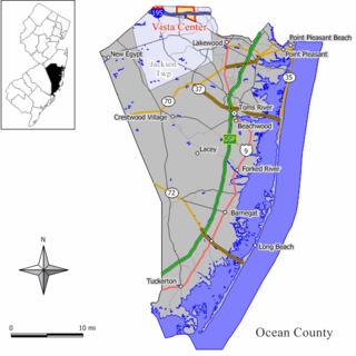
Vista Center is an unincorporated community and census-designated place (CDP) located within Jackson Township in Ocean County, in the U.S. state of New Jersey. As of the 2010 United States Census, the CDP's population was 3,689.

<span class="mw-page-title-main">Little Falls, New Jersey</span> Township in Passaic County, New Jersey, United States

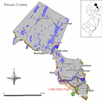
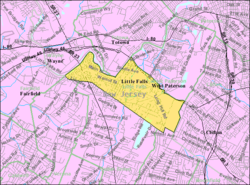
Little Falls is a township in Passaic County, in the U.S. state of New Jersey. The township was named for a waterfall on the Passaic River at a dam near Beattie Mill.

<span class="mw-page-title-main">Pompton Lakes, New Jersey</span> Borough in Passaic County, New Jersey, United States

Pompton Lakes is a borough in Passaic County, in the U.S. state of New Jersey. As of the 2020 United States census, the borough's population was 11,127, an increase of 30 (+0.3%) from the 2010 census count of 11,097, which in turn reflected an increase of 457 (+4.3%) from the 10,640 counted in the 2000 census.

Columbia is an unincorporated community and census-designated place (CDP) located within Knowlton Township in Warren County, in the U.S. state of New Jersey. While the community has existed for over a century, the CDP was created as part of the 2010 United States Census. As of the 2010 Census, the CDP's population was 229. The area is served as United States Postal Service ZIP Code 07832.

<span class="mw-page-title-main">Yardville, New Jersey</span> Populated place in Camden County, New Jersey, US

Yardville is an unincorporated community and census-designated place (CDP) located within Hamilton Township, in Mercer County, in the U.S. state of New Jersey. As of the 2010 United States Census, the CDP's population was 2,945. Before the 2010 Census, the area was part of the Yardville-Groveville CDP.

<span class="mw-page-title-main">Leisure Village West, New Jersey</span> Populated place in Ocean County, New Jersey, US

Leisure Village West is an unincorporated community and census-designated place (CDP) located within Manchester Township, in Ocean County, in the U.S. state of New Jersey. Until the 2000 census, the CDP had been part of the Leisure Village West-Pine Lake Park CDP, which was split for the 2010 enumeration into separate CDPs for Leisure Village West and Pine Lake Park. As of the 2010 United States Census, the CDP's population was 3,493. Leisure Village West is one of several active adult communities bearing similar names. Leisure Village and Leisure Village East are the other two communities nearby.

Broadway is an unincorporated community and census-designated place (CDP) located within Franklin Township, in Warren County, in the U.S. state of New Jersey, that was created as part of the 2010 United States Census. As of the 2010 Census, the CDP's population was 244.

<span class="mw-page-title-main">Kingston Estates, New Jersey</span> Populated place in Camden County, New Jersey, US

Kingston Estates is an unincorporated community and census-designated place (CDP) located within Cherry Hill, in Camden County, in the U.S. state of New Jersey, that had been part of the Barclay-Kingston CDP until the 2000 census, which was split to form the CDPs of Barclay and Kingston Estates as of the 2010 Census. As of the 2010 United States Census, the CDP's population was 5,685.

<span class="mw-page-title-main">Hope (CDP), New Jersey</span> Populated place in Warren County, New Jersey, US

Hope is an unincorporated community and census-designated place (CDP) located within Hope Township in Warren County, in the U.S. state of New Jersey, that was defined as part of the 2010 United States Census. As of the 2010 Census, the CDP's population was 195.

References

  1. 1 2 3 4 Gazetteer of New Jersey Places, United States Census Bureau. Accessed July 21, 2016.
  2. 1 2 US Gazetteer files: 2010, 2000, and 1990, United States Census Bureau. Accessed September 4, 2014.
  3. "ArcGIS REST Services Directory". United States Census Bureau. Retrieved October 11, 2022.
  4. U.S. Geological Survey Geographic Names Information System: Singac Census Designated Place, Geographic Names Information System. Accessed January 16, 2013.
  5. 1 2 "Census Population API". United States Census Bureau. Retrieved October 11, 2022.
  6. Look Up a ZIP Code for Singac, NJ, United States Postal Service. Accessed January 16, 2013.
  7. U.S. Census website, United States Census Bureau. Accessed September 4, 2014.
  8. Geographic Codes Lookup for New Jersey, Missouri Census Data Center. Accessed June 9, 2023.
  9. US Board on Geographic Names, United States Geological Survey. Accessed September 4, 2014.
  10. Geographic codes for New Jersey, Missouri Census Data Center. Accessed June 9, 2023.
  11. Alex, Patricia. "Steeped in history, choked by traffic", The Record , November 1, 1999. Accessed June 11, 2023, via Newspapers.com. "Singac - pronounced SING-ack, an English approximation of the Native American name for a local brook - and Willowbrook lie on either side of a tight bend in the river."
  12. GCT-PH1 - Population, Housing Units, Area, and Density: 2010 - County -- County Subdivision and Place from the 2010 Census Summary File 1 for Passaic County, New Jersey Archived 2020-02-12 at archive.today , United States Census Bureau. Accessed January 12, 2013.
  13. 2006-2010 American Community Survey Geography for New Jersey, United States Census Bureau. Accessed January 12, 2013.
  14. New Jersey: 2010 - Population and Housing Unit Counts - 2010 Census of Population and Housing (CPH-2-32), United States Census Bureau, August 2012. Accessed January 12, 2013.
  15. Locality Search, State of New Jersey. Accessed April 19, 2015.
  16. 1 2 3 4 DP-1 - Profile of General Population and Housing Characteristics: 2010 Demographic Profile Data for Singac CDP, New Jersey, United States Census Bureau. Accessed January 16, 2013.
  17. Philhower, Charles A. (1930). New Jersey: A History - Aboriginal Inhabitants Of New Jersey. New York, NY: American Historical Society.
  18. The Origin Of New Jersey Place Names (PDF). Trenton, NJ: New Jersey Public Library Commission.
  19. Nelson, William; and Shriner, Charles Anthony. History of Paterson and Its Environs (the Silk City), p. 72. Lewis Historical Publishing Company, 1920. Accessed July 21, 2023. "Singack - A neighborhood about five miles southwest of Paterson; it is commonly called by the old people, 'The Singack.' The name is from schinghacki, a flat country, whence is derived schingask, a boggy meadow. The name given to this neighborhood describes it accurately; it is a flat country along the Passaic river and is frequently overflowed in times of freshet."
  20. Funk, Richard W. "Building diners was specialty of several companies", Standard-Speaker , December 2, 2001. Accessed July 21, 2023, via Newspapers.com. "New Jersey could be considered the capital of the diner industry.... Mountain View Diners of Singac, N.J., was in business from 1939 to 1957. Hazleton's Blue Comet is a heavily remodeled 1957 model. This firm was known as a very aggressive marketer in the 1950s and its diners were shipped all over the country."
  21. "Census of Population and Housing". Census.gov. Retrieved June 4, 2016.