
Buldhana district is located in the Amravati division of Maharashtra, India . The name of the district is probably derived from Bhil Thana. It is situated at the western border of Vidarbha region and is 500 km away from the state capital, Mumbai. The district has towns and cities like Shegaon, Jalgaon Jamod, Malkapur, Khamgaon, Lonar, Mehkar, and Chikhli. It is surrounded by Madhya Pradesh in the north, Akola, Washim, and Amravati districts on the east, Jalna district on the south, and Jalgaon and Aurangabad districts on the west. Latitudes are 19.51° to 21.17° N and longitudes are 75.57° to 76.59° E. Bounded on the north by Madhya Pradesh state, to the east by Akola and Washim, to the south by Parbhani and Jalna districts, and to the west by Jalna and Jalgaon districts.

Haveri is a district in the state of Karnataka, India. As of 2011, it had a population of 1,597,668, out of which 20.78% were urban residents. The district headquarters is Haveri.

Bagalkote district, is an administrative district in the Indian state of Karnataka. The district headquarters is located in the town of Bagalkote. The district is located in northern Karnataka and borders Belagavi, Gadag, Koppal, Raichur and Vijayapura. The new Bagalkote district was carved out of Vijayapura in 1997 via Government of Karnataka directive Notification RD 42 LRD 87 Part III. The bifurcated Bagalkote district consists of nine taluks — Badami, Bagalkote, Bilagi, Guledgudda, Rabkavi Banhatti, Hunagund, Ilkal, Jamakhandi and Mudhol.

Jaisalmer is the largest district in the Indian state of Rajasthan, and the third largest district in India. Located in Marwar, the city of Jaisalmer is the administrative headquarters of the district. It is around 289 km (180 mi) from the city of Jodhpur, and around 559 km (347 mi) from Jaipur, the capital of Rajasthan. As of the 2011 population census, it is the least populous district out of all 33 districts in Rajasthan.

Uttara Karnataka, is a geographical region in Deccan plateau from 300 to 730 metres elevation that constitutes the region of the Karnataka state in India. It is drained by the Krishna River and its tributaries the Bhima, Ghataprabha, Malaprabha, and Tungabhadra. North Karnataka lies within the Deccan thorn scrub forests ecoregion, which extends north into eastern Maharashtra. Most parts of the region has black fertile soil ideal for agriculture.
Yadgir is a city and the administrative headquarters of Yadgir district in the Indian state of Karnataka. It is also the administrative headquarters of Yadgir Taluku, one of the six taluks of yadgir.

Gadag-Betageri is a city municipal council in Gadag district in the state of Karnataka, India. It is the administrative headquarters of Gadag District. The original city of Gadag and its sister city Betageri have a combined city administration. The municipality of Gadag-Betageri has a population of 172,813 and an area of 54.0956 km2 (20.8864 sq mi). Kanaginahal of Gadag is the birthplace of the first co-operative society in Asia. The temples of Veera Narayana and Trikuteshwara are places of religious and historic importance.

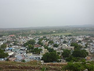
Mundaragi is a municipal town in Gadag district in the Indian state of Karnataka. Mundargi is close to two district headquarters, being 36 kilometres (22 mi) from Gadag and 50 kilometres (31 mi) from Koppal. It is 99 kilometers from Gajendragad. Mundargi is also the taluka headquarter of the same name. Pin code of Mundaragi is 582118.
Shiggaon, also known as Shiggavi, is a municipal town in Haveri district in the Indian state of Karnataka.

Mayureswar II is a community development block that forms an administrative division in Rampurhat subdivision of Birbhum district in the Indian state of West Bengal.
Mohammad Bazar is a community development block that forms an administrative division in Suri Sadar subdivision of Birbhum district in the Indian state of West Bengal.
Shirahatti is a panchayat town in Gadag district in the Indian state of Karnataka.
Hirewaddatti is a village in the southern state of Karnataka, India. It is located in the Mundargi taluk of Gadag district in Karnataka.
Shigli is a city located in the Shirhatti taluk of Gadag district in Karnataka. It is situated 52 kilometres (32 mi) to the south of district headquarters Gadag, 26 km (16 mi) from Shirhatti, and 382 km (237 mi) from state capital Bangalore. Shigli's pin code is 582210, and the postal head office is Shigli.
Venkateshwara Temple Ramenahalli is a Lord Venkateshwara Temple situated at Ramenahalli in Mundargi taluk of Gadag district in the Indian state of Karnataka. Hammigi is located south of district headquarters Gadag and Taluka headquarters Mundargi.

Rajnagar is a community development block that forms an administrative division in Suri Sadar subdivision of Birbhum district in the Indian state of West Bengal.

Ilambazar is a community development block that forms an administrative division in Bolpur subdivision of Birbhum district in the Indian state of West Bengal.
Hammigi is a village in the Mundargi taluk of Gadag district in the Indian state of Karnataka. Hammigi is located south to district headquarters Gadag and Taluka headquarters Mundargi
Korlahalli is a village in the Mundargi taluk of Gadag district in the Indian state of Karnataka. Korlahalli is located south to district headquarters Gadag and Taluka headquarters Mundargi.
Bidarahalli is a village located in Mundargi taluk in Gadag district, Karnataka, India.

