Smithville, Mississippi

Last updated

Smithville, Mississippi
Smithville-water-tower-ms.jpg
Water tower in Smithville (2018)
Motto(s): 
"Dig in and grow with us" [1]
Monroe County Mississippi Incorporated and Unincorporated areas Smithville Highlighted.svg
Location in Monroe County and the state of Mississippi
Usa edcp location map.svg
Red pog.svg
Smithville, Mississippi
Location in the United States
Coordinates: 34°4′7″N88°23′44″W / 34.06861°N 88.39556°W / 34.06861; -88.39556
Country United States
State Mississippi
County Monroe
Area
[2]
  Total1.61 sq mi (4.17 km2)
  Land1.48 sq mi (3.84 km2)
  Water0.12 sq mi (0.32 km2)
Elevation
262 ft (80 m)
Population
 (2020) [3]
  Total509
  Density342.99/sq mi (132.45/km2)
Time zone UTC-6 (Central (CST))
  Summer (DST) UTC-5 (CDT)
ZIP code
38870
Area code 662
FIPS code 28-68720
GNIS feature ID0677945
Website smithvillems.org

Smithville is a town in Monroe County, Mississippi, United States. The population was 509 at the 2020 census, [4] down from 942 in 2010.

Contents

History

Smithville is located on lands purchased from Chickasaw chief Che-lah-cha-chubby in 1836. The town is named for William Smith, an early settler who established a store at the site around 1840. The town was incorporated in 1845. [5]

2011 tornado

On April 27, 2011, at approximately 3:45 p.m. CDT, an EF5 tornado struck the town with winds which were estimated to have peaked at 205 mph (330 km/h). [6] A total of 16 people were killed, [7] and 40 people were injured. [6] In total, 117 structures were destroyed and 50 more sustained major damage from the storm in Monroe County alone, before the tornado continued into Itawamba County. In Smithville, an SUV was lofted and thrown a half mile into the water tower, making a dent, before being carried even further downwind. Other damage included the complete destruction of the city hall, post office, police station, and four churches, along with appliances and plumbing fixtures being shredded or ripped away from foundations and numerous granite tombstones being knocked down. [8]

Geography

Smithville is located in northern Monroe County at 34°4′7″N88°23′44″W / 34.06861°N 88.39556°W / 34.06861; -88.39556 (34.068605, -88.395486). [9] The town is situated along the east bank of the Tennessee-Tombigbee Waterway. The waterway's Glover Wilkins Lock is located just downstream (west). Mississippi Highway 25 traverses Smithville, connecting the town with Fulton to the north and Amory to the south.

According to the U.S. Census Bureau, the town has a total area of 1.6 square miles (4.1 km2), of which 1.5 square miles (3.9 km2) are land and 0.1 square miles (0.26 km2), or 7.71%, are water. [2]

Demographics

Historical population
CensusPop.Note
1900 150
1910 17919.3%
1920 138−22.9%
1930 401190.6%
1940 4020.2%
1950 4194.2%
1960 48916.7%
1970 55212.9%
1980 86656.9%
1990 8710.6%
2000 8821.3%
2010 9426.8%
2020 509−46.0%
U.S. Decennial Census [10]

As of the census [11] of 2000, there were 882 people, 365 households, and 243 families residing in the town. The population density 602.1 people per square mile (233.2/km2). There were 404 housing units at an average density of 275.8 per square mile (106.5/km2). The racial makeup of the town is 97.62% White, 1.59% African American, 0.11% Native American, 0.23% Asian, 0.23% from other races, and 0.23% from two or more races. Hispanic or Latino of any race were 0.79% of the population.

There were 365 households, out of which 33.7% had children under the age of 18 living with them, 47.9% were married couples living together, 14.5% had a female householder with no husband present, and 33.4% were non-families. 32.1% of all households were made up of individuals, and 18.4% had someone living alone who 65 years of age or older. The average household size 2.42 and the average family size 3.03.

In the town, the population spread out, with 26.2% under the age of 18, 10.2% from 18 to 24, 25.2% from 25 to 44, 22.9% from 45 to 64, and 15.5% who were 65 years of age or older. The median age 36 years. For every 100 females, there were 95.1 males. For every 100 females age 18 and over, there were 83.9 males.

The median income for a household in the town $32,583, and the median income for a family $38,750. Males had a median income of $30,294 versus $23,958 for females. The per capita income for the town $14,030. About 7.1% of families and 11.2% of the population were below the poverty line, including 9.7% of those under age 18 and 18.7% of those age 65 or over.

Education

Smithville is served by the Monroe County School District. [12]

Smithville High School won two 1A football state championships in 1993 and 1998. The school previously vied for the title in 1989, losing to a Mt. Olive (MS) team quarterbacked by future NFL great Steve McNair. The Smithville High School softball team has won the 1A state championship in 2008, 2011, and 2012. [13] The Smithville High School Band has won two state marching championships.

Notable people

Related Research Articles

<span class="mw-page-title-main">Sharkey County, Mississippi</span> County in Mississippi, United States

Sharkey County is a county located in the U.S. state of Mississippi. Part of the eastern border is formed by the Yazoo River. According to the 2020 census, the population was 3,800, making it the second-least populous county in Mississippi, after Issaquena County. Its county seat is Rolling Fork. The county is named after William L. Sharkey, the provisional Governor of Mississippi in 1865.

<span class="mw-page-title-main">Monroe County, Mississippi</span> County in Mississippi, United States

Monroe County is a county on the northeast border of the U.S. state of Mississippi next to Alabama. As of the 2020 census, the population was 34,180. Its county seat is Aberdeen.

<span class="mw-page-title-main">Reform, Alabama</span> City in Alabama, United States

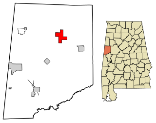
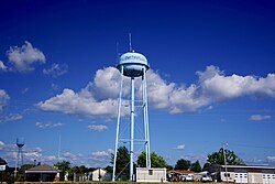
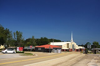
Reform is a city in Pickens County, Alabama, United States. At the 2010 census the population was 1,702, down from 1,978 in 2000. It is located approximately halfway between Columbus, Mississippi and Tuscaloosa on U.S. Route 82.

<span class="mw-page-title-main">Gorham, Illinois</span> Village in Illinois, United States

Gorham is a village in Jackson County, Illinois, United States. The population was 236 at the 2010 census. It is known locally for its near-annihilation during the deadly Tri-State Tornado of 1925.

<span class="mw-page-title-main">Renova, Mississippi</span> Town in Mississippi, United States

Renova is a town in Bolivar County, Mississippi, United States.Per the 2020 census, the population was 676. The community was founded by African Americans and remains predominantly African American.

<span class="mw-page-title-main">Weir, Mississippi</span> Town in Mississippi, United States

Weir is a town in Choctaw County, Mississippi, United States. The population was 459 at the 2010 census, down from 553 at the 2000 census.

<span class="mw-page-title-main">Silver City, Mississippi</span> Town in Mississippi, United States

Silver City is a town in Humphreys County, Mississippi, United States. The population was 217 at the 2021 census, a massive decline from the 2000 census.

<span class="mw-page-title-main">Tremont, Mississippi</span> Town in Mississippi, United States

Tremont is a town in Itawamba County, Mississippi, United States. It was founded in 1852. The population was 465 at the 2010 census, up from 390 at the 2000 census.

<span class="mw-page-title-main">Bassfield, Mississippi</span> Town in Mississippi, United States

Bassfield is a town in Jefferson Davis County, Mississippi, United States. The population was 192 at the 2020 census, down from 254 at the 2010 census.

<span class="mw-page-title-main">Plantersville, Mississippi</span> Town in Mississippi, United States

Plantersville is a town in Lee County, Mississippi. The population was 868 at the 2020 census.

<span class="mw-page-title-main">Amory, Mississippi</span> City in Mississippi, United States

Amory is a city in Monroe County, Mississippi, United States. The population was 6,666 at the 2020 census, down from 7,316 in 2010. Located in the northeastern part of the state near the Alabama border, it was founded in 1887 as a railroad town by the Kansas City, Memphis and Birmingham Railroad. As a result, Cotton Gin Port, along the Tombigbee River to the east, was abandoned as businesses and people moved for railroad access.

<span class="mw-page-title-main">Gattman, Mississippi</span> Village in Mississippi, United States

Gattman is a village in Monroe County, Mississippi. The population was 77 at the 2020 census, down from 90 in 2010.

<span class="mw-page-title-main">Hatley, Mississippi</span> Town in Mississippi, United States

Hatley is a town in Monroe County, Mississippi. The population was 495 at the 2020 census.

<span class="mw-page-title-main">Beaumont, Mississippi</span> Town in Mississippi, United States

Beaumont is a town in Perry County, Mississippi. It is part of the Hattiesburg, Mississippi Metropolitan Statistical Area, and located on the edge of the De Soto National Forest. The population was 951 at the 2010 census.

<span class="mw-page-title-main">Inverness, Mississippi</span> Town in Mississippi, United States

Inverness is a town in Sunflower County, Mississippi, United States. The population was 1,019 at the 2010 census. As the town had the largest cotton gin in the Mississippi Delta, it served as a gathering place for farmers from the region when they brought their cotton for processing. The town was heavily damaged by a tornado in 1971.

<span class="mw-page-title-main">Golden, Mississippi</span> Town in Mississippi, United States

Golden is a town in Tishomingo County, Mississippi, United States. The population was 191 at the 2010 census. The village's current mayor is Davy Ginn.

<span class="mw-page-title-main">Smithville, Missouri</span> City in Missouri, United States

Smithville is a city in Clay and Platte counties in the U.S. state of Missouri and is part of the Kansas City metropolitan area, along the Little Platte River. The population was 10,406 at the 2020 United States Census.

<span class="mw-page-title-main">Lula, Mississippi</span> Town in Mississippi, United States

Lula is a town in Coahoma County, Mississippi, United States. Per the 2020 census, the population was 204.

<span class="mw-page-title-main">Blum, Texas</span> Town in Texas, United States

Blum is a town in Hill County, Texas, United States. The population was 383 at the 2020 census.

<span class="mw-page-title-main">Elizabeth, West Virginia</span> Town in West Virginia, United States

Elizabeth is a town in and the county seat of Wirt County, West Virginia, United States, situated along the Little Kanawha River. The population was 724 as of the 2020 census.

References

  1. "Welcome to Smithville". Smithville, Mississippi. Retrieved March 11, 2024.
  2. 1 2 "2023 U.S. Gazetteer Files: Mississippi". United States Census Bureau. Retrieved March 11, 2024.
  3. "P1. Race – Smithville town, Mississippi: 2020 DEC Redistricting Data (PL 94-171)". U.S. Census Bureau. Retrieved March 11, 2024.
  4. "Explore Census Data". data.census.gov. Retrieved July 8, 2022.
  5. Dalrymple Family Foundation historical marker at Smithville Town Hall. Information accessed September 15, 2018.
  6. 1 2 Public Information Statement. April 29, 2011, NOAA-National Weather Service Weather Forecast Office, Memphis, TN. Retrieved May 1, 2011
  7. "Smithville Tornado Victim Dies," Monroe360.com, April 2011. Accessed at the Internet Archive, September 18, 2018.
  8. National Climatic Data Center (2011). "NCDC Storm Events Database". National Oceanic and Atmospheric Administration. Retrieved April 26, 2011.
  9. "US Gazetteer files: 2010, 2000, and 1990". United States Census Bureau. February 12, 2011. Retrieved April 23, 2011.
  10. "Census of Population and Housing". Census.gov. Retrieved June 4, 2015.
  11. "U.S. Census website". United States Census Bureau . Retrieved January 31, 2008.
  12. "SCHOOL DISTRICT REFERENCE MAP (2010 CENSUS): Monroe County, MS" (PDF). U.S. Census Bureau. Archived (PDF) from the original on April 19, 2021. Retrieved March 5, 2021.
  13. "High School Baseball/Softball Scores". Northeast Mississippi Daily Journal. Retrieved May 22, 2012.
  14. Rowland, Dunbar (1917). The Official and Statistical Register of the State of Mississippi. Department of Archives and History. pp. 807–808.
  15. Guralnick, Peter (2014). Last Train to Memphis: The Rise of Elvis Presley. New York, New York: Little, Brown, and Company. p. 34. ISBN   9780316206792.
  16. Babington, Bruce; Barr, Charles, eds. (2018). The Call of the Heart: John M. Stahl and Hollywood Melodrama. East Barnet, United Kingdom: John Libbey Publishing. p. 37. ISBN   9780861969494.