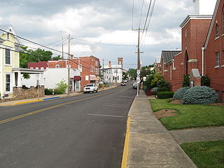
Sparta is a city in and the county seat of White County, Tennessee, United States. The population was 5,001 in 2020.

Craigsville is a town in Augusta County, Virginia, United States. The population was 923 at the 2010 census. It is part of the Staunton–Waynesboro Micropolitan Statistical Area.

Berryville is an incorporated town in and the county seat of Clarke County, Virginia, United States. The population was 4,574 at the 2020 census, up from 4,185 at the 2010 census.

The Plains is a small incorporated town in Fauquier County, Virginia, United States. The population was 245 as of the 2020 census, up from 217 at the 2010 census. It is centered on the intersection of VA 55 and VA 245. The town of The Plains is situated off I-66. As of 2022, the mayor of The Plains is Lori Sisson.

Halifax is a town in Halifax County, Virginia, United States, along the Banister River. The population was 1,309 at the 2010 census. It is the county seat of Halifax County.

Broadway is a town in Rockingham County, Virginia, United States. The population was 3,691 at the 2010 census. It is included in the Harrisonburg Metropolitan Statistical Area.

Dayton is a town in Rockingham County, Virginia, United States. The population is 1,530 as of the 2010 census. It is included in the Harrisonburg, Virginia Metropolitan Statistical Area.

Gordonsville is a town in Orange County in the Commonwealth of Virginia in the United States. Located about 19 miles northeast of Charlottesville and 65 miles northwest of Richmond, the population was 1,496 at the 2010 census.
Monroe is an unincorporated community in Amherst County, Virginia, United States. Monroe is located along U.S. Route 29 6.1 miles (9.8 km) north of Lynchburg.

Palmyra is a census-designated place (CDP) in and the county seat of Fluvanna County, Virginia, United States. The population as of the 2010 census was 104. Palmyra lies on the eastern bank of the Rivanna River along U.S. Route 15. The ZIP code for Palmyra and surrounding rural land is 22963.
Lafayette is a census-designated place (CDP) between the cities of Roanoke and Christiansburg in eastern Montgomery County, southwest Virginia, United States. The population as of the 2010 Census was 449. It is located adjacent to Elliston, at the confluence of the North and South Forks of the Roanoke River.

Santiam Junction is a highway junction and unincorporated community in Linn County, Oregon, United States, at the intersection of U.S. Route 20/Oregon Route 126 and Oregon Route 22.

Madison Mills is an unincorporated community located in Madison County, Virginia, United States. It is located at the intersection of U.S. Route 15 and Virginia State Route 230.
Arrington is a census-designated place (CDP) in Nelson County, Virginia, United States. The population as of the 2010 Census was 708.

Ivy is a census-designated place (CDP) in Albemarle County, Virginia, United States. The population as of the 2010 Census was 905. It is a small unincorporated community located on U.S. Route 250, just west of Charlottesville.

Deerfield is a census-designated place (CDP) in Augusta County, Virginia, United States. The population as of the 2010 Census was 132. It has a very low population density, as it is a small unincorporated rural area. The Deerfield mall is the main store of the town. Deerfield consists of farms, hunting areas, old plantation houses, and scenic views of the mountains. Deer, bear, and other forms of wildlife fill the area. Deerfield has its own post office, fire department, rescue squad, dump, and a historic school house. Students who live in Deerfield attend Churchville Elementary School, Beverley Manor Middle School, and Buffalo Gap High School.
Dailey is a census-designated place (CDP) in Randolph County, West Virginia, United States. Dailey is located on U.S. routes 219 and 250, 3 miles (4.8 km) south-southwest of Beverly. Dailey has a post office with ZIP code 26259. As of the 2010 census, its population was 114.

Evington is an unincorporated community in Campbell County, Virginia, United States. Evington is located along Virginia State Route 24, west of U.S. Highway 29, southwest of Lynchburg.

Trevilians is an unincorporated community in Louisa County, Virginia, United States. Trevilians is located at the junction of U.S. Route 33 and Virginia State Route 22 4 miles (6.4 km) west-northwest of Louisa. Trevilians has a post office with ZIP code 23170.

Crozier is an unincorporated community in Goochland County, Virginia, United States. Crozier is located on Virginia State Route 6, about 5.8 miles (9.3 km) east-southeast of Goochland. Crozier has a post office with ZIP code 23039.


