Gordonsville, Virginia

Last updated

Gordonsville, Virginia
Gordonsville Downtown 3.JPG
Looking down S. Main St
VAMap-doton-Gordonsville.PNG
Location of Gordonsville, Virginia
Coordinates: 38°8′5″N78°11′13″W / 38.13472°N 78.18694°W / 38.13472; -78.18694
Country United States
State Virginia
Counties Orange
Government
  MayorRobert K. Coiner
Area
[1]
  Total0.95 sq mi (2.46 km2)
  Land0.95 sq mi (2.46 km2)
  Water0.00 sq mi (0.00 km2)
Elevation
499 ft (152 m)
Population
 (2020) [2]
  Total1,402
  Density1,478.9/sq mi (571.0/km2)
Time zone UTC-5 (Eastern (EST))
  Summer (DST) UTC-4 (EDT)
ZIP code
22942
Area code 540
FIPS code 51-31936 [3]
GNIS feature ID1467264 [4]
Website Official website

Gordonsville is a town in Orange County [5] in the Commonwealth of Virginia in the United States. Located about 19 miles northeast of Charlottesville and 65 miles northwest of Richmond, the population was 1,402 at the 2020 census. [2]

Contents

The town celebrated its bicentennial in 2013, two hundred years after local innkeeper Nathaniel Gordon was appointed the area's first postmaster, thus officially creating the area known as Gordonsville. It was strategically important during the Civil War, due to its location on the Virginia Central Railroad. [6]

Gordonsville claims to have influenced the popularity of fried chicken in the United States; it bills itself as the "Fried Chicken Capital of the World." [7]

History

Pre-Civil War

In 1787, Nathaniel Gordon purchased 1,350 acres (5.46 square km) of land, then known as "Newville," from a cousin of President James Madison.

In 1794, or perhaps earlier, Gordon applied for and was granted a license to operate a tavern there, which, as was typical of the time, was used as a place to eat, lodge and discuss local matters. It sat at the intersection of two highways: "The Fredericksburgh Great Road," a stage route from Charlottesville, through Orange, to Fredericksburg; and "The Richmond Road," which led from the Virginia capital, through Louisa, west over the Blue Ridge Mountains into the Shenandoah Valley. President Thomas Jefferson described the tavern in 1802 as a "good house" when recommending the best route south to Charlottesville from the recently established national capital on the Potomac. The building was known as Gordon's Tavern, Gordon Tavern and later as Gordon Inn. The commemorative marker at the site lists prominent Americans as guests at the tavern: George Washington, Thomas Jefferson, James Monroe, James & Philip P. Barbour, James Waddel, William Wirt and Henry Clay. Another famous visitor was Major General the Marquis de Lafayette.

Gordon was named the first postmaster of the area in 1813, and the area became known as Gordonsville. At the time of Gordon's death in 1820, Gordonsville had, in addition to the tavern, a post office, several homes, a general mercantile store and a blacksmith shop. Nathaniel willed his land and tavern to his son, John, and near that same time Dr. Charles Beale (husband of Nathaniel's daughter, Mary) purchased adjoining land near what is currently Main Street. The later division and sale of lots from this property, and the construction of adjacent roads, would foster growth of the town up to and during the Civil War.

In 1839, the General Assembly authorized the extension of the Louisa Railroad (later the Virginia Central Railroad) from Louisa Courthouse to Gordonsville, which ushered in growth and prosperity for Gordonsville. It became a center of trade for the plantations and farms in the surrounding countryside. Two new roadways, the Blue Ridge Turnpike and the Rockingham Turnpike, were built to connect the town to New Market and Harrisonburg, respectively.

In 1854, the Orange & Alexandria Railroad completed its line into Gordonsville, connecting the area with northern portion of Virginia. Over the next few years, both railroad lines were extended, increasing Gordonsville's role as a transportation hub. The rail depots were constructed next to what is now S. Main Street.

Nathaniel Gordon's original tavern burned down in 1859. Richard F. Omohundro, who owned the land at the time, rebuilt what is now known as the Exchange Hotel. Following its completion in 1860, the hotel offered elegant lodging for rail passengers and other travelers. During the Civil War, it was used as a receiving hospital that saw more than 70,000 patients. It is now known as the Civil War Exchange Museum and is arguably the most historically and architecturally significant building in Gordonsville. [8] [9] [10]

During the Civil War and after

Gordonsville and the railroads which intersected there were of vital importance to the Confederacy for troop mobility and supplies. Troops from Richmond on the way to the First Battle of Bull Run on July 21, 1861, came through town. During the war years, Robert E. Lee, James Longstreet, Stonewall Jackson, Richard S. Ewell and A. P. Hill spent time in Gordonsville. Major Gen. Philip Sheridan led a raid in the direction of Gordonsville and Charlottesville but was stopped by Wade Hampton's Confederate cavalry in the vicinity of Trevilian Station. Gordonsville was threatened many times but was always successfully defended by the Confederates. The Civil War ended in 1865 and with Gordonsville being largely unscathed, passenger rail service was quickly reestablished. [9]

Gordonsville was officially incorporated into a town in 1870 by an act of the Virginia General Assembly. [11] The population then was approximately 1,500. In the following years it was "a flourishing and fast improving town" and its prosperity gave rise to then-superior educational facilities and fine examples of period architecture, many of which are still standing on N. Main and W. Baker Streets. Gordonsville had the unique reputation as a fast-food emporium in the 1870s, with an active market of food vendors serving rail travelers as they stopped in the town. [7] As alternative rail lines and roads were constructed bypassing Gordonsville, it morphed into a quiet, rural market town. Fires in 1916 and 1920 destroyed much of the downtown, with only a handful of buildings surviving to this day. Damage was repaired and buildings were rebuilt, largely shaping modern-day Gordonsville. The town has remained economically stable through current times, as has its population. [8]

In the early 1970s, following the 100-year anniversary of the town's incorporation, a nonprofit organization named Historic Gordonsville Inc. was formed. As of August 2013, the company owned a large number of properties downtown, including the Exchange Hotel. [12] Their renovation and preservation efforts have helped maintain the historic commercial core of Gordonsville. House Bill 847 was passed by the Virginia Assembly in 1996, which amended §10.1-2212 of the Virginia Code to add Historic Gordonsville, Inc. to the listing of historical societies eligible to receive appropriations from the Virginia Department of Historical Resources.

Places of historical significance

The Gordonsville Historic District, Black Meadow, Exchange Hotel, and Rocklands are listed on the National Register of Historic Places. [13] The historic district and the Exchange Hotel are both within the town limits of Gordonsville; Black Meadow and Rocklands are nearby.

Geography

Gordonsville is located at 38°8′5″N78°11′13″W / 38.13472°N 78.18694°W / 38.13472; -78.18694 (38.134628, -78.187068). [14]

According to the United States Census Bureau, the town has a total area of 0.9 square miles (2.4 km2), all of which is land.

Demographics

Historical population
CensusPop.Note
1880 919
1890 9624.7%
1900 603−37.3%
1910 564−6.5%
1920 5945.3%
1930 462−22.2%
1940 50810.0%
1950 1,118120.1%
1960 1,109−0.8%
1970 1,24412.2%
1980 1,42114.2%
1990 1,351−4.9%
2000 1,49810.9%
2010 1,496−0.1%
2020 1,402−6.3%
U.S. Decennial Census [15]

As of the 2010 U.S. Census, there were 1,496 people, 632 households, and 388 families residing in the town. The population density was 1,646.1 people per square mile (635.6/km2). There were 710 housing units, with an average density of 788.9 units per square mile (295.8/km2). The racial makeup of the town was 70.7% White, 23.7% African American, 0.5% Asian, 2.5% from other races and 2.5% from two or more races. Hispanic or Latino of any race were 4.3% of the population.

Out of the 632 households, 26.3% had children under the age of 18 living with them, 38.0% were married couples living together, 18.7% had a female householder with no husband present, 4.7% had a male householder with no wife present and 38.6% were non-family households. Householders living alone accounted for 34.8% of the total households and 30.5% had a resident who was 65 years of age or older. The average household size was 2.37 and the average family size was 3.05.

The age distribution of Gordonsville's population was 24.4% under the age of 18, 8.1% from 18 to 24, 22.9% from 25 to 44, 28.9% from 45 to 64, and 15.6% who were 65 years of age or older. The median age was 40.8 years. For every 100 females, there were 84 males. For every 100 females age 18 and over, there were 80 males.

The median income for a household in the town was $41,845, and the median income for a family was $52,000. Males working full-time had a median income of $38,421 versus $33,250 for females. The per capita income for the town was $20,545. About 14.2% of families and 19.6% of the total population were below the poverty line.

Of the population of 1,427 persons age 16 and older, 55.9% were in the labor force, all of which worked in civilian occupations.

View south along US 15 and east along US 33 in Gordonsville 2016-07-21 15 27 39 View south along U.S. Route 15 and east along U.S. Route 33 (Main Street) just southeast of Virginia State Route 231 (Gordon Avenue) in Gordonsville, Orange County, Virginia.jpg
View south along US 15 and east along US 33 in Gordonsville

Transportation

U.S. Route 15 and U.S. Route 33 are the main highways providing access to Gordonsville. US 15 extends north to Orange and south to connect with Interstate 64. US 33 extends west to Stanardsville and east to Louisa. Virginia State Route 231 also serves Gordonsville, extending north towards Madison and south towards Charlottesville.

Notable people

Climate

The climate in this area is characterized by hot, humid summers and generally mild to cool winters. According to the Köppen Climate Classification system, Gordonsville has a humid subtropical climate, abbreviated "Cfa" on climate maps. [16]

Related Research Articles

<span class="mw-page-title-main">Waynesboro, Virginia</span> Independent city in Virginia, United States

Waynesboro is an independent city in the Commonwealth of Virginia. It is a principal city of the Staunton-Waynesboro Metropolitan Statistical Area. Waynesboro is located in the Shenandoah Valley and is surrounded by Augusta County. As of the 2020 census, the population was 22,196.

<span class="mw-page-title-main">Orange County, Virginia</span> County in Virginia, United States

Orange County is a county located in the Central Piedmont region of the Commonwealth of Virginia. At the 2020 census, the population was 36,254. Its county seat is Orange. Orange County includes Montpelier, the 2,700-acre (1,100 ha) estate of James Madison, the 4th President of the United States and often known as the "Father of the Constitution". The county will celebrate its 290th anniversary in 2024.

<span class="mw-page-title-main">Charlottesville, Virginia</span> Independent city in Virginia, United States

Charlottesville, colloquially known as C'ville, is an independent city in Virginia, United States. It is the seat of government of Albemarle County, which surrounds the city, though the two are separate legal entities. It is named after Queen Charlotte. At the 2020 census, the population of the city was 46,553. The Bureau of Economic Analysis combines the City of Charlottesville with Albemarle County for statistical purposes, bringing its population to approximately 160,000. Charlottesville is the heart of the Charlottesville metropolitan area, which includes Albemarle, Buckingham, Fluvanna, Greene, and Nelson counties.

<span class="mw-page-title-main">The Plains, Virginia</span> Town in Virginia, United States

The Plains is a small incorporated town in Fauquier County, Virginia, United States. The population was 245 as of the 2020 census, up from 217 at the 2010 census. It is centered on the intersection of VA 55 and VA 245. The town of The Plains is situated off I-66. As of 2022, the mayor of The Plains is Lori Sisson.

<span class="mw-page-title-main">Louisa, Virginia</span> Town in Virginia, United States

Louisa is a town in Louisa County, Virginia, United States. The population was 1,555 at the 2010 census. It is the county seat of Louisa County.

<span class="mw-page-title-main">Blackstone, Virginia</span> Town in Virginia, United States

Blackstone, formerly named Blacks and Whites, and then Bellefonte, is a town in Nottoway County in the U.S. state of Virginia. The population was 3,621 at the 2010 census.

<span class="mw-page-title-main">Burkeville, Virginia</span> Town in Virginia, United States

Burkeville is an incorporated town in Nottoway County, Virginia, United States. The population was 432 at the 2010 census. The source of the town name is disputed. The town is located at the crossroads of U.S. routes 360 and 460.

<span class="mw-page-title-main">Orange, Virginia</span> Town in Virginia, United States

Orange is a town and the county seat of Orange County, Virginia, United States. The population was 5,062 at the 2020 census, representing a 7.2% increase since the 2010 census. Orange is 28 miles (45 km) northeast of Charlottesville, 88 miles (142 km) southwest of Washington, D.C., and 4 miles (6 km) east of Founding Father and fourth U.S. president James Madison's plantation of Montpelier.

<span class="mw-page-title-main">Courtland, Virginia</span> Town in Southampton County, Virginia, US

Courtland is an incorporated town in Southampton County, Virginia, United States. It is the county seat of Southampton County.

<span class="mw-page-title-main">Falmouth, Virginia</span> Census-designated place in Virginia, United States

Falmouth is a census-designated place (CDP) in Stafford County, Virginia, United States. Situated on the north bank of the Rappahannock River at the falls, the community is north of and opposite the city of Fredericksburg. Recognized by the U.S. Census Bureau as a census-designated place (CDP), Falmouth's population was 4,956 as of the 2020 census.

<span class="mw-page-title-main">Orange and Alexandria Railroad</span>

The Orange and Alexandria Railroad (O&A) was a railroad in Virginia, United States. Chartered in 1848, it eventually extended from Alexandria to Gordonsville, with another section from Charlottesville to Lynchburg. The road played a crucial role in the American Civil War, saw the first of many mergers in 1867, and eventually became an important part of the modern-day Norfolk Southern rail system.

<span class="mw-page-title-main">Virginia Central Railroad</span> Railroad in Virginia

The Virginia Central Railroad was an early railroad in the U.S. state of Virginia that operated between 1850 and 1868 from Richmond westward for 206 miles (332 km) to Covington. Chartered in 1836 as the Louisa Railroad by the Virginia General Assembly, the railroad began near the Richmond, Fredericksburg and Potomac Railroad's line and expanded westward to Orange County, reaching Gordonsville by 1840. In 1849, the Blue Ridge Railroad was chartered to construct a line over the Blue Ridge Mountains for the Louisa Railroad which reached the base of the Blue Ridge in 1852. After a decision from the U.S. Supreme Court, the Louisa Railroad was allowed to expand eastward from a point near Doswell to Richmond.

Catlett is a census-designated place (CDP) in Fauquier County, Virginia, United States. The population as of the 2010 census was 297. It is located west of the Prince William County line. Catlett was formerly a rail stop on the Orange and Alexandria Railroad, and the area was the site of many raids on the railroad during the American Civil War.

<span class="mw-page-title-main">National Register of Historic Places listings in Virginia</span>

Buildings, sites, districts, and objects in Virginia listed on the National Register of Historic Places:

<span class="mw-page-title-main">Keswick, Virginia</span> Unincorporated community in Virginia, United States

Keswick is a census-designated place in Albemarle County, Virginia, United States, about six miles east of Charlottesville.

<span class="mw-page-title-main">U.S. Route 15 in Virginia</span> Section of United States Numbered Highway in Virginia

U.S. Route 15 (US 15) is a part of the United States Numbered Highway System that runs from Walterboro, South Carolina, to Painted Post, New York. In Virginia, the U.S. Highway runs 230.37 miles (370.74 km) from the North Carolina state line near Clarksville north to the Maryland state line at the Potomac River near Lucketts. US 15 is a major north–south highway through the Piedmont of Virginia, connecting Clarksville and Farmville in Southside with Culpeper, Warrenton, and Leesburg in Northern Virginia.

<span class="mw-page-title-main">Virginia State Route 22</span> State highway in central Virginia, US

State Route 22 is a primary state highway in the U.S. state of Virginia. The state highway runs 29.81 miles (47.97 km) from U.S. Route 250 in Shadwell east to US 522 and SR 208 in Mineral. SR 22 is one of two primary east–west highways in Louisa County, connecting the county seat of Louisa with Charlottesville and Mineral. The state highway runs concurrently with US 33 through Louisa and with SR 208 between Louisa and Mineral.

<span class="mw-page-title-main">Virginia State Route 231</span> State highway in Virginia, United States

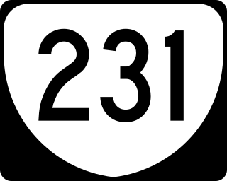
State Route 231 is a primary state highway in the U.S. state of Virginia. The state highway runs 49.82 miles (80.18 km) from SR 22 in Cismont north to U.S. Route 522 near Sperryville. SR 231 forms part of the connection between Charlottesville and Gordonsville, where the highway meets US 15 and US 33. The state highway also serves as the main north–south highway of Madison County, connecting the county seat of Madison, where the highway intersects US 29, with Gordonsville to the south and passing through the foothills of the Blue Ridge Mountains to the north.

<span class="mw-page-title-main">Rapidan station</span> United States historic place

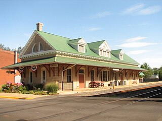
The Rapidan Passenger Depot is located at the junction of VA 614, VA 615, and VA 673 in Rapidan, Virginia, United States.

<span class="mw-page-title-main">Exchange Hotel (Gordonsville, Virginia)</span> United States historic place

The Exchange Hotel in Gordonsville, Virginia, was built in 1860 for Richard F. Omohundro next to an important railroad junction, when the Exchange Hotel offered a welcome stopping place for weary passengers on the Virginia Central Railroad.

References

  1. "2020 U.S. Gazetteer Files". United States Census Bureau. Retrieved March 19, 2024.
  2. 1 2 "Profile of General Population and Housing Characteristics: 2020 Demographic Profile Data (DP-1): Gordonsville town, Virginia". United States Census Bureau . Retrieved March 19, 2024.
  3. "U.S. Census website". United States Census Bureau . Retrieved January 31, 2008.
  4. "US Board on Geographic Names". United States Geological Survey. October 25, 2007. Retrieved January 31, 2008.
  5. "List of Towns and their Parent Counties". Archived December 27, 2016, at the Wayback Machine Virginia Department of Housing and Community Development website. April 19, 2012. Retrieved January 25, 2013.
  6. Feeney, W. R. "Gordonsville During the Civil War". (February 6, 2012). In Encyclopedia Virginia. Retrieved from http://www.EncyclopediaVirginia.org/Gordonsville_During_the_Civil_War
  7. 1 2 Ober, Lauren (July 3, 2015). "How Gordonsville, Virginia, Became The 'Fried Chicken Capital of the World'". WAMU . Retrieved January 25, 2021.
  8. 1 2 O'Dell, Jeff. July 1983. Virginia Historic Landmarks Commission. "National Register of Historic Places - Nomination Form: Gordonsville Historic District." Retrieved August 14, 2013. http://www.dhr.virginia.gov/registers/Counties/Orange/225-0030_Gordonsville_HD_1983_Final_Nomination.pdf
  9. 1 2 The Journey Through Hallowed Ground. "Gordonsville, VA." Retrieved August 14, 2013. http://www.hallowedground.org/Explore-the-Journey/Historic-Towns-Villages/Gordonsville-VA
  10. Thomas, William H. B. June 1973. Virginia Landmarks Commission. "National Register of Historic Places Inventory - Nomination Form: Exchange Hotel." Retrieved August 15, 2013. http://www.dhr.virginia.gov/registers/Counties/Orange/225-0008_Exchange_Hotel_1973_Final_Nomination.pdf
  11. Commonwealth of Virginia Division of Legislative Services. "Charters." Retrieved August 14, 2013. http://dls.virginia.gov/charters/Gordonsville.pdf
  12. Orange County Commissioner of Revenue Property Tax Records. Retrieved August 15, 2013. https://tax.orangecountyva.gov/applications/txapps/index.htm Archived August 17, 2013, at the Wayback Machine
  13. "National Register Information System". National Register of Historic Places . National Park Service. July 9, 2010.
  14. "US Gazetteer files: 2010, 2000, and 1990". United States Census Bureau. February 12, 2011. Retrieved April 23, 2011.
  15. "Census of Population and Housing". Census.gov. Retrieved June 4, 2015.
  16. Climate Summary for Gordonsville, Virginia

Further reading