Bedford, Virginia

Last updated

Bedford, Virginia
Bedford County Courthouse.jpg
Bedford County Courthouse
Bedford.gif
Nickname: 
The World's Best Little Town
Motto: 
Life. Liberty. Happiness.
VAMap-doton-Bedford.png
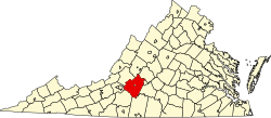
Location in Virginia
Coordinates: 37°20′04″N79°31′23″W / 37.33444°N 79.52306°W / 37.33444; -79.52306
Country United States
State Virginia
County Bedford County
Government
  TypeTown Council
Area
[1]
  Total8.75 sq mi (22.67 km2)
  Land8.72 sq mi (22.59 km2)
  Water0.03 sq mi (0.07 km2)
Elevation
1,004 ft (306 m)
Population
 (2020)
  Total6,657
  Density760/sq mi (290/km2)
Time zone UTC-5 (Eastern (EST))
  Summer (DST) UTC-4 (EDT)
ZIP code
24523
Area code 540
FIPS code 51-05544 [2]
GNIS feature ID1498450 [3]
Website http://www.bedfordva.gov

Bedford is an incorporated town and former independent city located within Bedford County in the U.S. state of Virginia. It serves as the county seat of Bedford County. As of the 2020 census, the population was 6,657. It is part of the Lynchburg Metropolitan Statistical Area.

Contents

Bedford County surrounds the town and has the Blue Ridge Mountains to the north, Smith Mountain Lake to the south, Lynchburg to the east, and Roanoke to the west.

History

Bedford was originally known as Liberty, "named after the Colonial victory over Cornwallis at Yorktown." [4] Founded as a village in 1782, Liberty became Bedford County's seat of government, replacing New London which had become part of the newly formed Campbell County. Liberty became a town in 1839 and in 1890 changed its name to Bedford City. In 1912, Bedford reverted to town status, it resumed city status in 1968, [5] and once more it reverted to a town in 2013. [6]

In November 1923, the town was the site of an accidental mass poisoning in which nine men were killed after drinking apple cider served at the Elks National Home. A local farmer had produced the drink and stored in a barrel that had been used to hold a pesticide. [7]

Bedford is home to the National D-Day Memorial (despite the "National" in its name, the memorial is owned and operated by a non-governmental, non-profit, education foundation). The United States Congress warranted that this memorial would be the nation's D-Day Memorial and President Bill Clinton authorized this effort in September 1996. President George W. Bush dedicated this memorial as the nation's D-Day memorial on June 6, 2001. Bedford lost more residents per capita in the Normandy landings than any other American community. Nineteen of the thirty-four Virginia National Guard soldiers from Bedford who were in Company A, 116th Infantry Regiment, 29th Infantry Division were killed on D-Day, and four more died during the rest of the Normandy campaign, two of them from other 116th companies. With a 1944 population of about 3,200, proportionally this community suffered the nation's most severe D-Day losses. [8] [9]

Bedford was designated as an independent city in 1968, but remained the county seat of Bedford County. Its status as an independent city was ended on July 1, 2013, returning to a town within Bedford County. [10]

Geography

According to the United States Census Bureau, the town has a total area of 6.9 square miles (18 km2), of which 6.9 square miles (18 km2) is land and 0.02 square miles (0.052 km2) (0.3%) is water. [11]

Bedford sits at the foot of the Peaks of Otter.

Demographics

The D-Day National Memorial, as viewed from the nearby visitor center D-Day National Memorial.jpg
The D-Day National Memorial, as viewed from the nearby visitor center
Historical population
CensusPop.Note
1860 722
1870 1,20867.3%
1880 2,19181.4%
1890 2,89732.2%
1900 2,416−16.6%
1910 2,5083.8%
1920 3,24329.3%
1930 3,71314.5%
1940 3,9737.0%
1950 4,0612.2%
1960 5,92145.8%
1970 6,0111.5%
1980 5,991−0.3%
1990 6,0731.4%
2000 6,2993.7%
2010 6,222−1.2%
2020 6,6577.0%
U.S. Decennial Census [12]
1790-1960 [13] 1900-1990 [14]
1990-2000 [15] 2010-2012 [16]

2020 census

At the 2020 census there were 6,657 people in the town. There were 3,163 housing units. The racial makeup of the city was 74.4% White, 16.8% Black or African American, 0.2% American Indian, 0.7% Asian, 0.1% Pacific Islander, 1.2% from other races, and 6.7% from two or more races. Hispanic or Latino of any race were 2.9%.

2000 census

At the 2000 census there were 6,299 people in 2,519 households, including 1,592 families, in the then city. The population density was 914.5 persons per square mile (353.1 persons/km2). There were 2,702 housing units at an average density of 392.3 per square mile (151.5/km2). The racial makeup of the city was 75.33% White, 22.38% Black or African American, 0.24% Native American, 0.57% Asian, 0.08% Pacific Islander, 0.24% from other races, and 1.16% from two or more races. Hispanic or Latino of any race were 0.89%. [17]

Of the 2,519 households, 27.7% had children under the age of 18 living with them, 43.0% were married couples living together, 17.2% had a female householder with no husband present, and 36.8% were non-families. 33.0% of households were one person, and 15.7% were one person aged 65 or older. The average household size was 2.26 and the average family size was 2.87.

In the city the population was spread out, with 21.6% under the age of 18, 7.2% from 18 to 24, 27.8% from 25 to 44, 20.7% from 45 to 64, and 22.6% 65 or older. The median age was 41 years. For every 100 females, there were 90.6 males. For every 100 females age 18 and over, there were 85.4 males.

The median household income was $29,792 and the median family income was $35,023. Males had a median income of $31,668 versus $18,065 for females. The per capita income for the city was $15,423. About 11.4% of families and 12.7% of the population were below the poverty line, including 19.4% of those under age 18 and 11.1% of those age 65 or over.

Economy

Top employers

The cupola atop the Bedford County Court House was built in 1866. Bedford County Court House.jpg
The cupola atop the Bedford County Court House was built in 1866.

According to the town's 2022 Annual Comprehensive Financial Report, [18] the top employers in the town are:

#Employer# of Employees
1Centra Bedford Memorial Hospital & Centra Medical Group364
2 Bedford County Public Schools 315
3 Walmart 301
4Sam Moore Furniture LLC237
5Smyth Companies Bedford132
6 Cintas 130
7Bedford Weaving Mills123
8 Lowe's 117
9 English Meadows 70
10 Food Lion 63

Education

Bedford is served by Bedford County Public Schools. Public school students residing in Bedford are zoned to attend Bedford Elementary School, Liberty Middle School, and Liberty High School.

Central Virginia Community College operates a branch campus in Bedford. [19]

Climate

The climate in this area is characterized by mild, humid summers and generally mild to cool winters. According to the Köppen Climate Classification system, Bedford has a humid subtropical climate, abbreviated "Cfa" on climate maps. [20]

Climate data for Bedford, Virginia (1991–2020 normals, extremes 1893–present)
MonthJanFebMarAprMayJunJulAugSepOctNovDecYear
Record high °F (°C)81
(27)
79
(26)
89
(32)
95
(35)
100
(38)
102
(39)
104
(40)
101
(38)
100
(38)
99
(37)
87
(31)
73
(23)
104
(40)
Mean daily maximum °F (°C)46.9
(8.3)
49.9
(9.9)
58.1
(14.5)
69.7
(20.9)
74.7
(23.7)
82.4
(28.0)
86.4
(30.2)
85.2
(29.6)
78.9
(26.1)
68.7
(20.4)
58.8
(14.9)
49.5
(9.7)
67.4
(19.7)
Daily mean °F (°C)37.3
(2.9)
39.2
(4.0)
47.1
(8.4)
57.4
(14.1)
64.3
(17.9)
72.1
(22.3)
76.5
(24.7)
74.9
(23.8)
68.7
(20.4)
57.5
(14.2)
48.1
(8.9)
40.4
(4.7)
57.0
(13.9)
Mean daily minimum °F (°C)27.8
(−2.3)
28.5
(−1.9)
36.0
(2.2)
45.1
(7.3)
53.8
(12.1)
61.8
(16.6)
66.7
(19.3)
64.7
(18.2)
58.6
(14.8)
46.2
(7.9)
37.3
(2.9)
31.3
(−0.4)
46.5
(8.1)
Record low °F (°C)−10
(−23)
−6
(−21)
4
(−16)
20
(−7)
28
(−2)
36
(2)
43
(6)
42
(6)
29
(−2)
21
(−6)
8
(−13)
−6
(−21)
−10
(−23)
Average precipitation inches (mm)3.62
(92)
3.01
(76)
3.45
(88)
3.85
(98)
4.60
(117)
4.71
(120)
4.29
(109)
3.81
(97)
4.37
(111)
3.59
(91)
3.27
(83)
3.74
(95)
46.31
(1,176)
Source: NOAA [21] [22]

Transportation

U.S. Route 221 runs through the town; and U.S. Route 460 circumvents the main part of town. State routes 43 and 122 converge onto the town.

Until the late 1960s, there were three different Southern Railway/Norfolk & Western Railroad trains operating daily at Bedford station. [23]

Amtrak service to Roanoke travels through, but there were plans to build a new station stop in Bedford. [24]

Bedford has a Friendship Treaty with:

Bedford maintains relationships with 11 communities on the Normandy Coast of France. One sister city, Trévières, France, sent Bedford an exact replica of its own World War I memorial statue. The face of the statue was damaged in World War II by artillery fire from US forces retaking the town. The Bedford statue also bears these wounds and is erected on the grounds of the National D-Day Memorial.

Notable people

Related Research Articles

<span class="mw-page-title-main">Lynchburg, Virginia</span> Independent city in Virginia, United States

Lynchburg is an independent city in the Commonwealth of Virginia in the United States. First settled in 1757 by ferry owner John Lynch, the city's population was 79,009 at the 2020 census, making Lynchburg the 11th most populous city in Virginia. Located in the foothills of the Blue Ridge Mountains along the banks of the James River, Lynchburg is known as the "City of Seven Hills" or the "Hill City". In the 1860s, Lynchburg was the only city in Virginia that was not recaptured by the Union before the end of the American Civil War.

<span class="mw-page-title-main">Buena Vista, Virginia</span> Independent city in Virginia, United States

Buena Vista is an independent city located in the Blue Ridge Mountains region of Virginia in the United States. As of the 2020 census, the population was 6,641. The Bureau of Economic Analysis combines the independent cities of Buena Vista and Lexington, along with surrounding Rockbridge County, for statistical purposes.

<span class="mw-page-title-main">Campbell County, Virginia</span> County in Virginia, United States

Campbell County is a United States county situated in the south central part of the Commonwealth of Virginia. Located in the Piedmont region of Virginia, Campbell borders the Blue Ridge Mountains. The county seat is Rustburg.

<span class="mw-page-title-main">Bedford County, Virginia</span> County in Virginia, United States

Bedford County is a United States county located in the Piedmont region of the Commonwealth of Virginia. Its county seat is the town of Bedford, which was an independent city from 1968 until rejoining the county in 2013.

<span class="mw-page-title-main">Amherst County, Virginia</span> County in Virginia, United States

Amherst County is a county, located in the Piedmont region and near the center of the Commonwealth of Virginia in the United States. The county is part of the Lynchburg Metropolitan Statistical Area, and its county seat is also named Amherst.

<span class="mw-page-title-main">Moore County, Tennessee</span> County in Tennessee, United States

Moore County is a county located in the south central part of the U.S. state of Tennessee. As of the 2020 census, the population was 6,461, making it the third-least populous county in Tennessee. It forms a consolidated city-county government with its county seat of Lynchburg. At 130 square miles (340 km2), it is the second-smallest county in Tennessee, behind only Trousdale. The county was created in 1871, during the Reconstruction era. Moore County is part of the Tullahoma-Manchester, TN Micropolitan Statistical Area.

<span class="mw-page-title-main">Highland County, Ohio</span> County in Ohio, United States

Highland County is a county located in the U.S. state of Ohio. As of the 2020 census, the population was 43,317. Its county seat is Hillsboro. The county is named for the topography which is hilly and divides the watersheds of the Little Miami and Scioto Rivers.

<span class="mw-page-title-main">Bedford, Iowa</span> City in Iowa, United States

Bedford is a city in Taylor County, Iowa, United States. The population was 1,508 at the 2020 census. It is the county seat of Taylor County. Lake of Three Fires State Park is located several miles northeast of Bedford.

<span class="mw-page-title-main">Everett, Pennsylvania</span> Borough in Pennsylvania, United States

Everett is a borough in Bedford County, Pennsylvania, United States. The population was 1,765 at the 2020 census.

<span class="mw-page-title-main">Appomattox, Virginia</span> Town in Virginia

Appomattox is a town in Appomattox County, Virginia, United States. The population was 1,733 at the 2010 census. It is the county seat of Appomattox County.

<span class="mw-page-title-main">Forest, Virginia</span> Census-designated place in Virginia, US

Forest is a census-designated place (CDP) in eastern Bedford County, Virginia, United States. The population was 11,709 at the 2020 census. It is part of the Lynchburg Metropolitan Statistical Area.

<span class="mw-page-title-main">Brookneal, Virginia</span> Town in Virginia, United States

Brookneal is an incorporated town in Campbell County, Virginia, United States. The population was 1,090 as of the 2020 census. It is part of the Lynchburg Metropolitan Statistical Area.

<span class="mw-page-title-main">Halifax, Virginia</span> Town in Virginia, United States

Halifax is a town in Halifax County, Virginia, United States, along the Banister River. The population was 1,309 at the 2010 census. It is the county seat of Halifax County.

<span class="mw-page-title-main">Glenville, West Virginia</span> Town in West Virginia, United States

Glenville is a town in and the county seat of Gilmer County, West Virginia, United States, along the Little Kanawha River. The population was 1,128 at the 2020 census. It is the home of Glenville State University.

<span class="mw-page-title-main">Petersburg, West Virginia</span> City in West Virginia, United States

Petersburg is a city in Grant County, West Virginia, United States. The population was 2,251 at the 2020 census. It is the county seat of Grant County.

<span class="mw-page-title-main">South Charleston, West Virginia</span> City in West Virginia, United States

South Charleston is a city in Kanawha County, West Virginia, United States. It is located to the west of the state capital of Charleston. The population was 13,639 at the 2020 census. It was established in 1906, but not incorporated until 1917. The Criel Mound built circa 0 BCE by the Adena culture is adjacent to the city's downtown business district.

<span class="mw-page-title-main">Piedmont, West Virginia</span> Town in West Virginia, United States

Piedmont is a town in Mineral County, West Virginia, United States. It is part of the Cumberland, MD-WV metropolitan statistical area. The population was 716 at the 2020 census. Piedmont was chartered in 1856 and the town is the subject of Colored People: A Memoir by Piedmont native Henry Louis Gates Jr.

<span class="mw-page-title-main">West Liberty, West Virginia</span> Town in West Virginia, United States

West Liberty is a town in Ohio County, West Virginia, United States. The population was 1,557 at the 2020 census. It is part of the Wheeling metropolitan area.

<span class="mw-page-title-main">New Martinsville, West Virginia</span> City in West Virginia, United States

New Martinsville is a city in and the county seat of Wetzel County, West Virginia, United States, along the Ohio River. The population was 5,186 at the 2020 census.

<span class="mw-page-title-main">Lynchburg metropolitan area</span> Metropolitan Statistical Area in Virginia, United States

The Lynchburg Metropolitan Statistical Area is a United States Metropolitan Statistical Area (MSA) in the state of Virginia, as defined by the Office of Management and Budget (OMB) as of June 2003. As of the 2000 census, the MSA had a population of 228,616. In 2009 this was estimated to have risen to 247,447; as of 2016, the Lynchburg MSA was estimated to have a population of 260,320, making it the fifth-largest metro area in the state.

References

  1. "2019 U.S. Gazetteer Files". United States Census Bureau. Retrieved August 7, 2020.
  2. "U.S. Census website". United States Census Bureau . Retrieved January 31, 2008.
  3. "US Board on Geographic Names". United States Geological Survey. October 25, 2007. Retrieved January 31, 2008.
  4. Bedford County Sheriff's Office, Welcome to Bedford County!
  5. Bedford, Virginia Online, About the Town of Bedford Archived October 5, 2014, at the Wayback Machine
  6. Faulconer, Justin (July 1, 2013). "Bedford reversion to town becomes official today". The News & Advance. Lynchburg, VA. Archived from the original on August 1, 2017. Retrieved July 22, 2013.
  7. "VA Poisoned Cider Kills Nine at Elks Home". New York Times. November 12, 1923. Retrieved September 23, 2020.
  8. 1 2 Goldstein, Richard (April 23, 2009). "Ray Nance, Last of the Bedford Boys, Dies at 94". The New York Times.
  9. "Why Bedford?". National D-Day Memorial Foundation. Archived from the original on September 27, 2015. Retrieved April 22, 2016.
  10. Faulconer, Justin. "Bedford Reversion to Town Becomes Official Today". The News and Advance. newsadvance.com. Archived from the original on August 1, 2017. Retrieved July 21, 2013.
  11. "US Gazetteer files: 2010, 2000, and 1990". United States Census Bureau. February 12, 2011. Retrieved April 23, 2011.
  12. "U.S. Decennial Census". United States Census Bureau. Retrieved January 5, 2014.
  13. "Historical Census Browser". University of Virginia Library. Retrieved January 5, 2014.
  14. "Population of Counties by Decennial Census: 1900 to 1990". United States Census Bureau. Retrieved January 5, 2014.
  15. "Census 2000 PHC-T-4. Ranking Tables for Counties: 1990 and 2000" (PDF). United States Census Bureau. Retrieved January 5, 2014.
  16. "State & County QuickFacts". United States Census Bureau. Archived from the original on January 6, 2014. Retrieved January 5, 2014.
  17. "U.S. Census website". United States Census Bureau . Retrieved May 14, 2011.
  18. "Town of Bedford ACFR" . Retrieved August 7, 2023.
  19. "Bedford CVCC".
  20. Climate Summary for Bedford, Virginia
  21. "NowData – NOAA Online Weather Data". National Oceanic and Atmospheric Administration. Retrieved July 2, 2021.
  22. "Station: Bedford, VA". U.S. Climate Normals 2020: U.S. Monthly Climate Normals (1991-2020). National Oceanic and Atmospheric Administration. Retrieved July 2, 2021.
  23. Norfolk and Western Timetable, April 1966 documenting stops at the Bedford station http://streamlinermemories.info/South/N&W66-4TT.pdf
  24. Cockerham, Amy (December 5, 2023). "Town of Bedford seeks funding for Amtrak stop". WSLS . Retrieved December 11, 2023.
  25. Ivybridge International Links Archived July 8, 2008, at the Wayback Machine from the Ivybridge Town Guide
  26. Catherine Reef (January 1, 2004). African Americans in the Military. Infobase Publishing. pp. 56–7. ISBN   978-1-4381-0775-2 . Retrieved November 3, 2016.
  27. "Death Notice, Mrs. Effie Cleland". Winston-Salem Journal . Winston-Salem, NC. United Press. January 21, 1956. p. 2 via Newspapers.com.
  28. Rogers, Kyle (2019). "D-Day 75th Anniversary – The Bedford Boys". The UncommonWealth: Voices from the Library of Virginia. Archived from the original on August 18, 2021. Retrieved August 18, 2021.
  29. Kershaw, Alex (2003). The Bedford boys : one American town's ultimate D-Day sacrifice (1st Da Capo Press ed.). Cambridge, Mass.: Da Capo Press. ISBN   0-585-48196-2. OCLC   53896163.

37°20′05″N79°31′22″W / 37.334591°N 79.522783°W / 37.334591; -79.522783